Agriculture is the principal employment of the people; coal is worked at Oakshaw, but on a very limited scale; and lime, though found within the parish, is of no commercial importance. The soil is generally a cold clay, and wet, except on the banks of the Lyne, where there are some dry rich fields. The whole parish is diversified with vales and rising grounds, but with nothing that can properly be termed hills; but the beautifully wooded ravines through which the Lyne flows give it a picturesque appearance. The rivers White Lyne and Black Lyne flow through the parish, forming the boundary lines between the townships, and are crossed by two good stone bridges built in 1891 at a cost of £1,250. The old chain bridge, erected more than half a century ago, still remains. It crosses the river at a beautiful and romantic spot between Rowel Town in Stapleton arid Gibstown in Solport. There is only room for one person at a time, and the sensation experienced by people unaccustomed to crossing it is most peculiar.
STAPLETON township occupies the northern portion of the parish, and is distant about eight miles N. from Brampton. It contains, according to the Ordnance Survey, about 4,744 acres, assessed at £2,353, buildings £612, and had in 1891, 378 inhabitants. According to the Denton M.SS. the manor of Stapleton was a demesne of Gilsland, and granted as a fee to the lords of Kirklevington. In the reign of Edward III it was held by a family bearing the local name. It was subsequently possessed by the Dacres, the Howards, the Earl of Carlisle, and is now the property of Sir Richard James Graham. The other landowners of the township are Mary Amos; Mrs. Watson, Holme Eden; Mrs. A.F. Hetherington; Major-General De Vitre, Bournmouth; Edward Wilson Parker, Esq., Carleton Derrick, Penrith; Col. Aitchison, Messrs. William and James Kyle, Joseph Laidler, Esq.
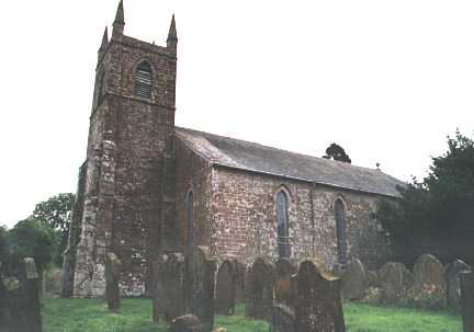 The
Church, dedicated to St. Mary, stands about the centre of the township,
near the Kirkbum rivulet. It is an ancient foundation, but the present edifice
was erected in 1830 upon the site of the old church. It is a plain Gothic
building, consisting of nave, chancel, porch, and tower, carrying four
pinnacles, and cost about £1,000, of which £300 was given by the Church Building
Society. There is sitting accommodation for 204 persons. The windows are all of
the lancet kind, that in the chancel being filled with stained glass, on which
are emblazoned the arms of the Earl of Carlisle, Sir James Graham, and the
Bishop of Carlisle. The benefice is a rectory, valued in the King's Book at £8
1s, 11d,, but now worth £160. This income is derived from the following
sources:- A modus of £12 in lieu of tithes; glebe land, £85; interest of an
augmentation received from Queen. Anne's Bounty, £29; surplice fees about £14;
interest of £400 invested with the Ecclesiastical Commissioners, £26 13s. 4d.
This sum was given in equal shares by James Farish, Esq., of Dormansteads, and
the Diocesan Church and Parsonage Building and Benefice Augmentation Society.
The patronage of the church was formerly exercised by the Earls of Carlisle and
the Grahams of Netherby alternately; but, by a lawsuit which took place some
years ago between the two, the Earl of Carlisle was constituted sole patron of
the living. In the churchyard is an ancient tombstone bearing the inscription:-
"Here lies Robert (Hob) Forrester, of Stanegarthside, 1598" From the word Hob
being placed over Robert it would seem he was familiarly known as Hob Forrester.
Another headstone records the death of William Mitchinson, who died at Howdale,
in 1896, aged 100 years. A white marble tablet in the church is to the memory of
the Rev. Thomas Fell, rector of Stapleton for 25 years, who died February 22nd,
1898; erected by the parishioners and friends. The present rector is the Rev. E.
Hindle, B.A. The Wesleyan Chapel at Bowel Town was restored about ten years ago
at a cost of £260. It will accommodate about 200.
The
Church, dedicated to St. Mary, stands about the centre of the township,
near the Kirkbum rivulet. It is an ancient foundation, but the present edifice
was erected in 1830 upon the site of the old church. It is a plain Gothic
building, consisting of nave, chancel, porch, and tower, carrying four
pinnacles, and cost about £1,000, of which £300 was given by the Church Building
Society. There is sitting accommodation for 204 persons. The windows are all of
the lancet kind, that in the chancel being filled with stained glass, on which
are emblazoned the arms of the Earl of Carlisle, Sir James Graham, and the
Bishop of Carlisle. The benefice is a rectory, valued in the King's Book at £8
1s, 11d,, but now worth £160. This income is derived from the following
sources:- A modus of £12 in lieu of tithes; glebe land, £85; interest of an
augmentation received from Queen. Anne's Bounty, £29; surplice fees about £14;
interest of £400 invested with the Ecclesiastical Commissioners, £26 13s. 4d.
This sum was given in equal shares by James Farish, Esq., of Dormansteads, and
the Diocesan Church and Parsonage Building and Benefice Augmentation Society.
The patronage of the church was formerly exercised by the Earls of Carlisle and
the Grahams of Netherby alternately; but, by a lawsuit which took place some
years ago between the two, the Earl of Carlisle was constituted sole patron of
the living. In the churchyard is an ancient tombstone bearing the inscription:-
"Here lies Robert (Hob) Forrester, of Stanegarthside, 1598" From the word Hob
being placed over Robert it would seem he was familiarly known as Hob Forrester.
Another headstone records the death of William Mitchinson, who died at Howdale,
in 1896, aged 100 years. A white marble tablet in the church is to the memory of
the Rev. Thomas Fell, rector of Stapleton for 25 years, who died February 22nd,
1898; erected by the parishioners and friends. The present rector is the Rev. E.
Hindle, B.A. The Wesleyan Chapel at Bowel Town was restored about ten years ago
at a cost of £260. It will accommodate about 200.
The school was founded previous to 1778, and has twice been rebuilt. The present premises were erected in 1871, at a cost of between £600 and £700. It has a small endowment of £11 2s. 6d. a year, and is attended by 60 children.
CHARITIES. - Edward Irving, Harper Hill, in 1778, bequeathed to the
rector of Stapleton, for the time being, and others, the sum of £80, the
interest, £2 6s. 8d.,to be divided as follows:- one-half to the school and the
other half to be divided on his tombstone among the poor not receiving parochial
relief. This charity is restricted to the township of Stapleton.
Sir Simon Howard, late of Carlisle, by will dated 14th March, 1843,
bequeathed to the clergyman and churchwardens of this parish the sum of £500 to
he invested by them, and the interest thereof to be applied for the purposes of
education in the said parish. A portion of this bequest was applied to the
rebuilding of the school, and there now remains between £360 and £370, the
interest of which is £9 19s. 0d.
SOLPORT township comprises 3,236 acres; it is assessed at: land, £1,680; buildings, £416; and has a population of 197 souls. The gross rental is about £2,441. It occupies the north-west portion of the parish, and was anciently the inheritance of the Levingtons, from whom after their failure in male issue, it passed to the Grahams of Netherby, and is now the property of Sir R.J. Graham. The manor embraces the townships of Solport, Belbank, and Trough. At Shank is an old ruined castle, once the manorial residence of the lords of Solport. The principal landowners are Colonel T.A. Irwin, Lynehow; Sir Richard James Graham, Bart., Netherby Hall; Messrs. Lawson, Redgate Head, Nichol Forest; Mrs. Watson, Holme Eden; Robert Dixon, Beyond-the-Moss; William Milburn, Spadeadam; Edward Graham, Birch Mire Boggs, Westlinton; &c., &c.
Holywell is a hamlet in this township; and here the Presbyterians have a small chapel and manse, restored in 1882, under the ministrations of the Rev. John Guthrie; and at "Thorney Land" is a Friends' Meeting House, at which the members of that society occasionally assemble. The school at Shank Hill was rebuilt about forty years ago, and enlarged in 1874 at a cost of about £100. It receives a portion of Sir S. Howard's bequest, which is given to the children of the poorest inhabitants.
Though the fairy lore which delighted or terrified our youthful imagination, according to the propensities of the little elves for good or evil, is now fast dying out before the light of the twentieth century, yet in some of these out-of-the-way parishes their memory still survives; and stories of Brownies or Dobies are told by the winter fire, or it may be some old dame will recount the vagaries of that arch-imp Wag-at-the-wa', and tell how
"Wag-at-tho-wa' went out i' the night,
To see that the moon was shining bricht,
The moon she was at the latter fa',
'Gang hame to yere beds! ' cried Wag-at-the-wa'."
A cavern in the rocky bank of the river Lyne, about a mile from Shank Castle, is pointed out as the spot where the fairies used to dwell; and in the river, opposite the cavern, is a mass of rock with a flat top, on which they are said to have performed their nightly dance. This is the Fairies Table, and another large heather-covered rock is known as the Fairies Castle.
Trough township is situated on the north side of the river Lyne, near Belbank, and contains 2,338 statute acres. It is assessed for the county and other rates, at the following value:- Land, £918 15s.; buildings, etc., £186 5s.; gross rental, £1,266 13s. 9d. The population in 1891 was 125. The principal landowners are the lord of the manor, Thomas Routledge, Robert Bell, Mrs. Broome, Mrs. Fitzgerald, Mrs. Little, John Fawkes, John Lamb, Messrs. Burrow, Benson, and Forster, and W. Davidson.
Beibank township comprises 1,446 acres, which are assessed at £612; buildings, £129; gross rental, £855; and contains a population of 77. The principal landowners are Fred, Robert Brown, Burnfoot; Messrs. Murray, Whisgills and Saughtree; Mrs. Routledge, Crook; William Routledge, Crook; Christopher Routledge, 69 Currock terrace, Carlisle; James Robert Kyle, Sorbie Trees; William F. Maxwell, Houghton; Messrs. Burrow, Benson and Forster.
The hamlet of Belbank is situated on the White Lyne, a little above its confluence with the Black Lyne, and about a mile north of the Parish Church. A small bed of coal exists at Oakshaw.
The Rev. William Graham, rector of this parish from 1771 till his death in 1796, published a translation in verse of the Eclogues of Virgil, and also some sermons. He was a native of Arthuret, where his parents resided in very humble circumstances. He was sent early to work, and by the savings of his youth he was afterwards enabled to prosecute his studies.