Bassenthwaite1 lake, nearly four miles in length and one in breadth, is situated about nine miles north of Buttermere, and three and a half miles north-west of Keswick. On one side it is bounded by a range of lofty hills, called Wythop Brows2; and on the other by verdant pastures and cultivated fields; and the lofty Skiddaw rears its majestic head about two miles east of its south end. It has no islands, and its western side is rather too uniformly wooded; but its opposite shore has a great breadth of cultivation, with some fine bays and promontories, so that tourists, who have leisure for a ride of eighteen miles round this extensive water may enjoy a pleasing view over its glassy surface. Pike and perch are its principal fish, but salmon pass through it to deposit their spawn in the Derwent and Greta rivers. About three miles and a half north-east of the foot of the lake is Over Water Tarn, at the source of the river Ellen; and about seven miles of it is Bowscale Tarn3, which empties itself into the Caldew, and is seated in a basin singularly scooped of the side of a hill.
Skiddaw - "A view of the country, from at least one
of the highest mountains with which this county abounds, is considered as forming part of
the tour by those who can 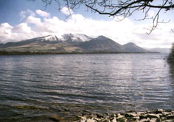 master strength and resolution for the undertaking; and for this purpose,
Skiddaw is on several accounts generally selected. It is nearest to the station at
Keswick, most easy of access (as ladies may ride on horseback to the very summit), and
standing in some measure detached, the view, especially to the north and west, is less
intercepted by other mountains. An extensive prospect being the principal motive for
climbing a mountain, it is a question frequently asked, which is the best time of day for
going up Skiddaw? It is not easy to give a precise answer to this interrogation. The
morning is often recommended; and, generally, the sooner you are there after the sun has
shone out and the cloud left the mountain, the better. It is a grievous, though not an
uncommon circumstance to be enveloped in a cloud, which seems to be continually passing
on, yet never leaves the mountain during the time appropriated for the stay; but those who
are fortunate enough to be upon the summit at the very time of the clouds departure will
experience a gratification of no common kind - when, like the rising of the curtain in a
theatre, the country in a moment bursts upon the eye."
master strength and resolution for the undertaking; and for this purpose,
Skiddaw is on several accounts generally selected. It is nearest to the station at
Keswick, most easy of access (as ladies may ride on horseback to the very summit), and
standing in some measure detached, the view, especially to the north and west, is less
intercepted by other mountains. An extensive prospect being the principal motive for
climbing a mountain, it is a question frequently asked, which is the best time of day for
going up Skiddaw? It is not easy to give a precise answer to this interrogation. The
morning is often recommended; and, generally, the sooner you are there after the sun has
shone out and the cloud left the mountain, the better. It is a grievous, though not an
uncommon circumstance to be enveloped in a cloud, which seems to be continually passing
on, yet never leaves the mountain during the time appropriated for the stay; but those who
are fortunate enough to be upon the summit at the very time of the clouds departure will
experience a gratification of no common kind - when, like the rising of the curtain in a
theatre, the country in a moment bursts upon the eye."
Skiddaw commands a prospect of the greater part of Cumberland; all the coast from St Bees' Head to Solway Frith4, with the several bays and promontories, the Isle of Man, and a considerable portion of the southern part of Scotland. The summit of Ingleborough, in Yorkshire, is seen over the range of hills which bound the head of Ullswater; and a glimpse of the sea, near Lancaster, may be had through the gap at Dunmail Raise. The only lakes seen are Derwent and Bassenthwaite, and only one of these can be viewed from the summit.
Mr. Green's large work describes numerous objects visible from Skiddaw, all of which are pointed out by a guide, if the state of the atmosphere renders them discernable.
The value of the prospects "is not found in straining the eye to see a something that the imagination may convert into either the Irish mountains or a fog-bank - a distant gleam of sunshine, or a reflection from the German ocean5 - a speck of condensed vapour, or a ship on the glittering sea: it lies rather in beholding a country richly variegated with fields of corn, fit for the sickle - meadows green as emerald - hills, clad with purple heath - lakes with winding shores and beautiful islands - rivers, shining like silver as they shape their serpentine courses towards the Irish sea - and in tracing the effects of light and shade upon mountains in every imaginable diversity of form." The view from the summit of some of the neighbouring mountains may rival, or, (in the opinion of some) exceed in grandeur the view from the summit of this, but in no other ascent are the prospects equalled, which unfold themselves in the ascent of Skiddaw, when overlooking the lake and vale of Derwent, with the Borrowdale and Newland mountains. A portion of ground, forming part of the north and east sides of Skiddaw, and consisting of inferior elevations and heathy ground, is generally overlooked as uninteresting, though it shows the granite rock, and its junction with the slate; contains veins of lead and copper, also molybdena, tungsten, apatite, and some other scarce and curious minerals. It abounds with grouse, and affords excellent pasturage for sheep. Among the various mountain plants observed in the ascent, are the different species of Lycopodium, and Vaccinium, the Erica vulgaris, and Empetrum nigrum; and on the summit, the Salix herbacea peeps forth amongst the stones. The rock is mostly a dark coloured clay-slate, in which are discovered small embedded crystals of chiastolite. The summit of Skiddaw is upwards of 3022 feet above the level of the sea; and its distance from Keswick, by various windings of the road, is nearly six miles north by west: Burn says "Skiddaw rises with two heads6 like unto Parnassus; and with a kind of emulation beholds Scruffell hill before it, in Annandale, in Scotland." By these mountains, according as the misty clouds rise or fall, the people dwelling thereabouts make their prognostications of the change of the weather, and have a common expression, that
"If Skiddaw hath a cap,
Scruffell7 wots full well of that."8
The parish is bounded by the parishes of Crosthwaite, Isell9, Torpenhow, Ireby, Uldale, and Caldbeck; and comprises 6930 acres, rated at £3079. The largest land owners are Sir H. R. Vane, Bart., John Spedding, Esq., and Mr. Richard Atkinson. On the west side of Skiddaw is an open pasture of 3000 acres, "stinted by grasses or gates, commonly called 'Cattle Gates,' " and, on the division of the common land, 2000A. were allotted to the freeholders, several of whom occupy their own farms. The soil on the N.W. part of the parish is of a wet and sterile nature, but, since the enclosure of the commons, has been much improved: near the mountains and the lake it is mostly light and gravelly - in some parts loamy, but in general, fertile. In the bowels of Skiddaw are many valuable minerals, though scarcely any mines are now wrought; the mine of antimony, which was opened some years ago, at a place called Robin Hood10, having proved a failure. The parish is comprehended in two constablewicks, one called Highside, and the other Hawes, or Lowside; and, in 1841, contained 536 inhabitants. It was anciently one entire manor, when granted by Waldeof, first lord of Allerdale, to his son, Gospatric, whose family assumed the local name of Bassenthwaite, and possessed it till the time of Edward II, when it was divided between the two daughters of Adam de Bassenthwaite. One of these carried her moiety in marriage to the Irtons, of Irton, but, having no issue, and surviving her husband, she again married one of the Lawsons, of Little Osworth, in Northumberland, in consequence of which her estate became vested in that family, and now belongs to Sir Wilfred Lawson, Bart., of Brayton Hall. The other sister married a Martindale, with whose descendants it remained till forfeited to the Crown on the attainder of Roger Martindale, when it was granted to the earl of Derby, with one of whose daughters (Lady Henrietta Stanley) it was given about the year 1714, to John, Lord Ashburton, who, in the following year, sold it to the tenants for £1825. Sir William Lawson, consequently, owns half the manorial right, and the freeholders the other half; but general Wyndham is lord paramount, and receives a yearly quit rent from the parish of £3 4s. 10d. He is also owner of the whole of the lake, except the three draughts called Ewes Bridge, Stone Wall, and Ellers Stile, in which Sir H. R. Vane, Bart., has a right to fish. "Soft pastoral scenes margin the lake on the eastern side, over which Skiddaw lifts an august brow, to give the boldest contrast to the green and gently rising eminences, the scattered coppices, the velvet-drest lawn, the rich verdure of the mead, the tranquil cottage, and the serene and shining mirror which the lake expands. The boldest landscape found here consists of irregular eminences, clothed with oaks, at whose feet a grassy margin lies to the water's brink, and holds some farm-fold; whilst the sublimer mountains, pile upon pile, lift up their heads, and, from the western sun, cast long shades upon the lake, whose distant shores catch the surpassing beams, and glow with additional beauty from the contrasting shades; over which the distant eminences mix their brows with the azure of the atmosphere. Such are the beauties of Bassenthwaite water."* The following lines are the close of a poem descriptive of the delightful vote of Bassenthwaite :-
"Had Pope this valley ever seen,
His Windsor Forest ne'er had been."
Bassenthwaite Church, dedicated to St. Bridget12, is a very ancient structure standing alone near the margin
of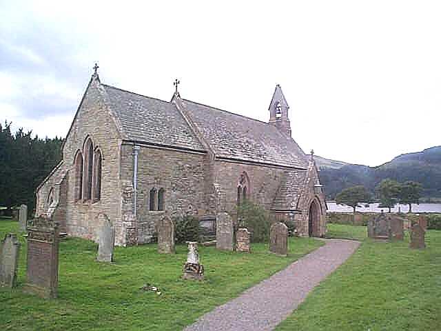 the lake, in Highside
division, five miles N.N.W. of Keswick. It was formerly rectorial, and is stated, by
Hutchinson, to have been "given to the abbey of Jedworth, by Waldeof, son of
Gospatric, and was soon after appropriated thereto." It is now a perpetual curacy, in
the patronage of the dean and chapter of Carlisle, and incumbency of the Rev. John Barnes.
At the enclosure of the commons, (in 1774), an allotment of land was awarded to the
curate, in lieu of all tithes. A lectureship11 was founded in
this church, in the beginning of the 17th century, by Matthew Cape, a merchant of
Carlisle, who endowed it with a lease of the tithes of corn and hay in Levington or
Linton-Holme, and Harper Hill. The living was certified to the governors of queen Anne's
bounty at £22 4s. 8d., and to the commissioners at £123; but it is now worth about £130
per annum. There is a parish school here, built by the inhabitants, but not endowed. A Mr.
Grace left five acres of land and a house for the parish clerk of Bassenthwaite; and the
poor of the parish have an allotment of land producing about £14 a year.
the lake, in Highside
division, five miles N.N.W. of Keswick. It was formerly rectorial, and is stated, by
Hutchinson, to have been "given to the abbey of Jedworth, by Waldeof, son of
Gospatric, and was soon after appropriated thereto." It is now a perpetual curacy, in
the patronage of the dean and chapter of Carlisle, and incumbency of the Rev. John Barnes.
At the enclosure of the commons, (in 1774), an allotment of land was awarded to the
curate, in lieu of all tithes. A lectureship11 was founded in
this church, in the beginning of the 17th century, by Matthew Cape, a merchant of
Carlisle, who endowed it with a lease of the tithes of corn and hay in Levington or
Linton-Holme, and Harper Hill. The living was certified to the governors of queen Anne's
bounty at £22 4s. 8d., and to the commissioners at £123; but it is now worth about £130
per annum. There is a parish school here, built by the inhabitants, but not endowed. A Mr.
Grace left five acres of land and a house for the parish clerk of Bassenthwaite; and the
poor of the parish have an allotment of land producing about £14 a year.
Armathwaite Hall, the seat of Lady and Sir H. R. Vane, Bart., occupies a delightful situation, at the lower extremity of the lake, of which it commands a fine view, 8½ miles N.N.W. of Keswick. Mirehouse, the seat and property of John Spedding, Esq., is a beautiful mansion, "situated between Skiddaw and the lake, upon a dry, fertile, and sandy soil." At a place called Chapel, in the Lowside constablewick, six miles N. by, W. of Keswick, is a small chapel of ease, built by the parishioners about the year 1471. Hawse or Halls, stands at the foot of Rawes Rake, 6½ miles N. by W. of Keswick. A feast, with sports, is held here in the early part of August, at which a considerable number of person assemble.
* Hutchinson
Mannix & Whellan, History, Gazetteer and Directory of Cumberland, 1847