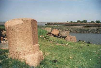
Bowness village is pleasantly situated on a rocky promontory, overlooking the Solway Frith2, and nearly opposite Annan, in Scotland, ten miles N. by W. of Wigton, and fourteen miles W. by N. of Carlisle. It occupies the site of the Tunnocelum3 of the Romans, and many relics of antiquity have been found here: at a place called Knockcross, near the village, the hilt of a sword with part of the blade, was found a few years ago; and about the year 1809, a "shackle" of gold, or a large gold ring, was found on the west common, near a place called Campfield. On a stone which is placed over a barn door in the village, is this inscription :-
IOM
PRO SALUTE
DD NN GALLI
FT VOLVSIANI
AV G G SVLPICIVS
SECVNDINVSTRIB
CO R POSVIT
Brownrigg, an old house, about one mile from the village, has evidently been a place of defence; the remains of the bell turret are still on one of the old gables, and on the ground floor the draw well is visible.
The township of Bowness contains 2093 acres, of the
rateable value of £2053 15s. mostly belonging to resident yeomen, but the earls of
Lonsdale, Mr. W. Wood,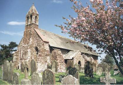 W.Hodgson, Esq., and Mrs. Reed, have estates here. The land
varies from a good reddish clay or marl, to a light gravelly soil, resting on blue clay.
The church, which is dedicated to St. Michael, is an ancient fabric, in the patronage of
the earl of Lonsdale, and incumbency of the Rev. Andrew Huddleston, D.D. for whom the Rev.
John Brown officiates. The benefice is valued in the king's books at £21 13s. 11d., but
is now worth about £450 per annum, arising from the tithes, commuted in 1838, for £326
5s. 6d., 57A. of glebe, 72A. on the west common, let for £42 a year, and 191 acres of
uncultivated land. The rectory house is very ancient, and some of the walls are upwards of
six feet thick. The parish school was enlarged about 12 years ago, and the master receives
£1 18s. 6d. a year from Pattinson's charity, and a liberal contribution from W. Hodgson,
Esq., who also contributes to Drumburgh and Fingland schools. In 1796, Robert Troutbeck
bequeathed the interest of £50 to the poor of Bowness, to be distributed annually, by a
Troutbeck, or the minister and churchwardens for the time being. The principal was
invested in 6A. 1R. of land, near Wigton, now let for £13 a year.
W.Hodgson, Esq., and Mrs. Reed, have estates here. The land
varies from a good reddish clay or marl, to a light gravelly soil, resting on blue clay.
The church, which is dedicated to St. Michael, is an ancient fabric, in the patronage of
the earl of Lonsdale, and incumbency of the Rev. Andrew Huddleston, D.D. for whom the Rev.
John Brown officiates. The benefice is valued in the king's books at £21 13s. 11d., but
is now worth about £450 per annum, arising from the tithes, commuted in 1838, for £326
5s. 6d., 57A. of glebe, 72A. on the west common, let for £42 a year, and 191 acres of
uncultivated land. The rectory house is very ancient, and some of the walls are upwards of
six feet thick. The parish school was enlarged about 12 years ago, and the master receives
£1 18s. 6d. a year from Pattinson's charity, and a liberal contribution from W. Hodgson,
Esq., who also contributes to Drumburgh and Fingland schools. In 1796, Robert Troutbeck
bequeathed the interest of £50 to the poor of Bowness, to be distributed annually, by a
Troutbeck, or the minister and churchwardens for the time being. The principal was
invested in 6A. 1R. of land, near Wigton, now let for £13 a year.
A large tract of moss land, containing several hundred acres, called Bowness Flow, situated near the river Wampool, in Bowness and Anthorn townships, is now undergoing the fertilizing process of drainage, under the superintendence of Mr. George Stewart. This great work was commenced in 1845, and already many acres of this hitherto unproductive waste are fit for cultivation. The depth of the morass is from 14 to 16 feet; and the two main drains, which lead to the Wampool and Solway Frith, are about that depth, and from two to three miles in length, which, with the side or cross drains now cut, make about forty miles. From a farm house, called Rogersceugh, situated on a small hill in the centre of this moss, is a fine panoramic view.
 Port Carlisle, formerly called Fisher's
Cross, is a modern village in this township, near the junction of the Eden and Esk
with the Solway Frith, 12 miles N.W. of Carlisle, and 11 miles N.N.W. of Wigton. About 16
years ago there were only two houses here, namely, Kirkland House, and a small inn, called
the "Binnacle;" there are now about 80 dwellings, amongst which are a good
hotel, and two inns, and the place is much frequented by sea bathers, for whom there is
good accommodation. Hot and cold baths have been lately constructed here at a cost of
£500 raised in £5 shares. When building the hotel, about 10 years ago, a small horse
shoe was found in the ruins of the Roman Wall; and Mr. Wm. Wood found a stag horn of an
immense size here a few years ago. During the formation of the canal from Carlisle which
terminates here, a great quantity of fine black oak was found near Kirkland House, a
portion of which is now converted into a large chair, by the Antiquarian Society of
Newcastle. A wooden pier, about 400 yards long, extends into the Solway Frith, and it is
in contemplation to construct a wet dock at this port., which has a considerable coal
trade to Ireland, &c., and a good commercial trade by steam, to Liverpool and Belfast.
The Solway Frith has been well buoyed and lighted by the Canal Company; and branch pilots
are stationed at Maryport, for the use of vessels navigating this water, whose depth at
the entrance is 18 feet 6 inches, whilst the depth at Liverpool Old Dock gates is only 17
feet. Foreign vessels, on entering this harbour, pay 6d., and coasters, 1d. per ton; the
anchorage is 10d. for each vessel. Were a railway constructed between this port and
Carlisle, or the canal converted into a railway, (of which there is rumour)4
we doubt not, this village would ere long become a populous and flourishing town. A fly
boat from Carlisle meets the packets here.
Port Carlisle, formerly called Fisher's
Cross, is a modern village in this township, near the junction of the Eden and Esk
with the Solway Frith, 12 miles N.W. of Carlisle, and 11 miles N.N.W. of Wigton. About 16
years ago there were only two houses here, namely, Kirkland House, and a small inn, called
the "Binnacle;" there are now about 80 dwellings, amongst which are a good
hotel, and two inns, and the place is much frequented by sea bathers, for whom there is
good accommodation. Hot and cold baths have been lately constructed here at a cost of
£500 raised in £5 shares. When building the hotel, about 10 years ago, a small horse
shoe was found in the ruins of the Roman Wall; and Mr. Wm. Wood found a stag horn of an
immense size here a few years ago. During the formation of the canal from Carlisle which
terminates here, a great quantity of fine black oak was found near Kirkland House, a
portion of which is now converted into a large chair, by the Antiquarian Society of
Newcastle. A wooden pier, about 400 yards long, extends into the Solway Frith, and it is
in contemplation to construct a wet dock at this port., which has a considerable coal
trade to Ireland, &c., and a good commercial trade by steam, to Liverpool and Belfast.
The Solway Frith has been well buoyed and lighted by the Canal Company; and branch pilots
are stationed at Maryport, for the use of vessels navigating this water, whose depth at
the entrance is 18 feet 6 inches, whilst the depth at Liverpool Old Dock gates is only 17
feet. Foreign vessels, on entering this harbour, pay 6d., and coasters, 1d. per ton; the
anchorage is 10d. for each vessel. Were a railway constructed between this port and
Carlisle, or the canal converted into a railway, (of which there is rumour)4
we doubt not, this village would ere long become a populous and flourishing town. A fly
boat from Carlisle meets the packets here.
Anthorn Township contains the small village of Anthorn, on the N. bank of the estuary of Wampool, 4½ miles S.W., and the village of Cardornock5, 4 miles W.S.W. of Bowness, situated on the verge of the tongue of land which terminates the parish, "almost environed with sea and morasses;" but the latter has been brought into a state of cultivation. A writer in the Gentleman's Magazine of 1748, calls the estuary of the Waver and Wampool, "Cardronoc Bay," and says it is very dangerous, "being full of quicksands, by reason the rivers and land waters, so that no traveller, or even inhabitant, can pass it with certainty at all times." The township, which also includes the hamlet of Longcroft, 3 miles S. by W. of Bowness, extends to the western extremity of the parish, and contains 2575 acres of land, chiefly of a gravelly nature, with a large tract of moss; 410 acres are called "ancient land," the rest was enclosed in 1826. Besides the resident yeomen, Messrs. J.R. Donald, John Messenger, George Doland, Robert Cullen, and Mrs. Wilson, have small estates here, but Solway House is the property of Mrs. Donald, of Carlisle. This pleasantly situated mansion, which overlooks the Solway, Waver, and Wampool, was built about the year 1830, by the late Mr. M. Hodgson, of Wigton, and is now the residence of W.C.F. Thomson, Esq. It is surrounded with thriving plantations, and commands extensive prospects.
Drumburgh Township has a village of its own name, occupying a pleasant situation on an eminence, 3½ miles S.E. of Bowness, and contains 2646a. 1r. 13p. of land, rated at £2314 10s. 6d., and mostly belonging to resident yeomen, of whom, Messrs. R. Lawson, F. Lawson, C. Watson, W. Wood, J. Pattinson, E. Barnes, and W. Borradaile, are the principal, but the earl of Lonsdale is the largest proprietor. His lordship has lately erected jetties for the preservation of Easton Marsh, which contains about 300 acres of rich soil, but which has suffered much from the ravages of the tide. Drumburgh Castle, now a farm house, is situated in the village, and the site of the Roman Station, Gabrosentum6, is still visible here. In this township is the village of Glasson, 2 miles S.E. of Bowness, where, until lately, might be traced vestiges of the old ditch and embankment, raised previous to the erection of the Roman Wall. There is a small Primitive Methodist Chapel here. Easton is a hamlet also in this township, 4½ miles E. by S. of Bowness. The school here receives £6 18s. 8d. yearly from the bequest of Thomas Pattinson, who was a native of Easton. The school at Drumburgh was built in 1834, by subscription, and a grant from the society for building schools.
Fingland is another township in this parish, containing a village of its own name, 5 miles S.S.E. of Bowness, and 10 miles W. of Carlisle; and the scattered hamlet of Whitrigg, 3 miles S. by E. of Bowness, situated on the north bank of the Wampool. It comprises 1864a. 3r. 27p. of land, rated at £1524 2s. 6d. belonging chiefly to residents, but Messrs. R. Lawson, E.C. Knubley, and Mr. Norman, have small estates here, and Fingland Rigg farm, is the property of the earl of Lonsdale. The school was built a few years ago, by subscription, and a grant from the school building society.
Mannix & Whellan, History, Gazetteer and Directory of Cumberland, 1847