The castle was again in a ruinous state, in the reign of
Henry III, in consequence of the damage done to it in 1216, when besieged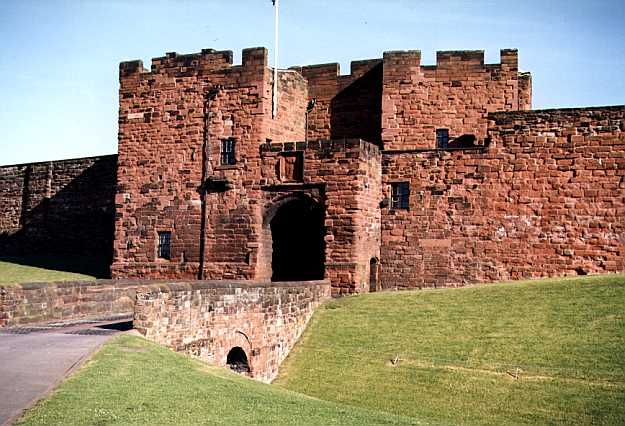 by Alexander of Scotland. In 1256, the return to a
commission of inquiry states that "the queen's chamber, Maunsell's turret, the turret
of William de Ireby, the chapel, the great hall, kitchen, and other offices," were
much decayed, having been the object of frequent attack. In 1344, an estimate of its
repairs were made, when the expense of repairing the stone work was stated at £200; the
wood works in the great tower, hall, and other buildings, at one hundred marks; and the
reparation of the walls, turrets, runnels, and gates, at £300.
by Alexander of Scotland. In 1256, the return to a
commission of inquiry states that "the queen's chamber, Maunsell's turret, the turret
of William de Ireby, the chapel, the great hall, kitchen, and other offices," were
much decayed, having been the object of frequent attack. In 1344, an estimate of its
repairs were made, when the expense of repairing the stone work was stated at £200; the
wood works in the great tower, hall, and other buildings, at one hundred marks; and the
reparation of the walls, turrets, runnels, and gates, at £300.
In the reign of Edward IV, Richard, duke of Gloucester, (afterwards Richard III) was governor of Carlisle, and sheriff of Cumberland; and Camden says, "this castle, king Richard III, as appears by his arms, repaired." In A.D. 1563, a report was made to queen Elizabeth, "that the dungeon tower (which should be the principal defence of the castle) was in a state of great decay, and although the walls were twelve feet thick, was in daily danger of falling." The castle, upon this report, was ordered to be thoroughly repaired, and it appears to have been of sufficient strength in the following century to stand a protracted siege.
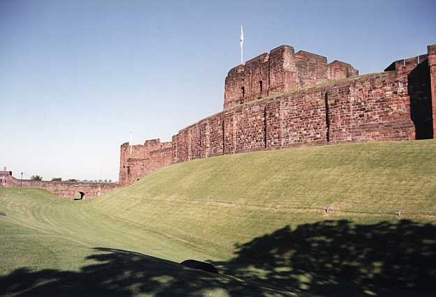 This ancient structure consists
of an outer ward, an inner ward, and the donjon tower or keep. The outer ward is nearly
square, and its walls are nine feet in thickness and eighteen feet in height, surmounted
by battlements. It contains the governor's house, (now an hospital,) old armoury, (now the
residence of the master gunner,) and barracks, (built in 1819,) for about 200 soldiers.
The old portcullis is still visible on entering the outer gate, above which is a defaced
piece of masonry representing the arms of Henry VII. The outer and inner wards are
separated by a wall and tower gate, defended by a half-moon battery, which was formerly
mounted with cannon, and strengthened by a wide and deep ditch, with a draw bridge. The
inner ward is of a triangular form, with walls twelve feet thick, and contains the keep,
or great tower, barracks for the officers, the magazine, and store keeper's office,
&c. There were formerly in this ward a chapel, queen Mary's tower, barracks for the
soldiers, and a great hall; the magazine was erected in 1827, on the site of the hall, and
the chapel has been converted into officers' barracks, and a mess-room, the old barracks
being pulled down in 1812. On the north side of the inner ward is a rampart, twenty-seven
feet thick, and has now five embrasures of cannon. Queen Mary's tower, so called from
having been the prison of Mary, queen of Scots, in 1568, was, in consequence of its
insecure state, taken down in 1834-5, when several Roman coins were discovered. The great
tower is a massive and lofty building, which is now used as an armoury, and contains
upwards of 6000 muskets, 1000 Irish pikes, and a considerable number of swords, bayonets,
&c. The top of this tower commands a rich and extensive prospect, the foreground of
which is formed of fertile meadows on the banks of the Eden. Towards the north-east are
seen the mountains about Bewcastle; to the south, the plains towards Penrith; and a vast
chain of mountains on either side, over which Cross Fell and Skiddaw are distinctly seen;
to the east, a rich tract of cultivated country, terminated by the heights of
Northumberland; to the westward, the Solway Frith2 spreads out
its expansive waters, margined on the south by fertile meadows, and on the north by
Scotland, where Criffle, and a chain of mountains, extend toward the sea. The keep is
nearly square, and its height from the ground to the top of the parapet is sixty-eight
feet, and consists of three stories, each sixteen feet in height, and the ground floor;
beneath the armoury on the latter are the dark and solitary dungeons, which are entered by
narrow doors, but into which the light of day cannot enter. In the eastern wall of the
keep are two cells, and on the walls of the outer one are carved the figures of men,
birds, and animals, with the crests of some of the ancient families of the county. Within
the north wall is a well, seventy-eight feet in depth, said to have been constructed by
the Romans, for the purpose of furnishing the garrison with such a supply of water as
could not be cut off by an assailing enemy. This is probably the identical well shown to
Saint Cuthbert, on his visit to the city, in 686. In cleansing it out, about forty years
ago, there was found a medal, having on one side the head and name of "His Royal
Highness, William, Duke of Cumberland," and on the other is represented a party
of retreating rebels, round which is inscribed, "The Pretender's last shift, or
Rebels' race for Life, 1745." Near the outer gate of the castle, were two stately
ash trees, probably the largest in the county, said to have been planted by the fair hands
of the unfortunate Mary, queen of Scots. They formed a very ornamental appendage to the
castle, but were cut down in 1804, by order of the Board of Ordnance. The usual promenade
of the royal captive, during her imprisonment here, is still called "the lady's
walk," but the door through which she came out has been walled up. On the city walls,
at a short distance from the castle, is a ruin, called king Richard's, or the Tile Tower,
from which there is a subterranean passage to the keep. At present there are only two guns
mounted upon the ramparts.
This ancient structure consists
of an outer ward, an inner ward, and the donjon tower or keep. The outer ward is nearly
square, and its walls are nine feet in thickness and eighteen feet in height, surmounted
by battlements. It contains the governor's house, (now an hospital,) old armoury, (now the
residence of the master gunner,) and barracks, (built in 1819,) for about 200 soldiers.
The old portcullis is still visible on entering the outer gate, above which is a defaced
piece of masonry representing the arms of Henry VII. The outer and inner wards are
separated by a wall and tower gate, defended by a half-moon battery, which was formerly
mounted with cannon, and strengthened by a wide and deep ditch, with a draw bridge. The
inner ward is of a triangular form, with walls twelve feet thick, and contains the keep,
or great tower, barracks for the officers, the magazine, and store keeper's office,
&c. There were formerly in this ward a chapel, queen Mary's tower, barracks for the
soldiers, and a great hall; the magazine was erected in 1827, on the site of the hall, and
the chapel has been converted into officers' barracks, and a mess-room, the old barracks
being pulled down in 1812. On the north side of the inner ward is a rampart, twenty-seven
feet thick, and has now five embrasures of cannon. Queen Mary's tower, so called from
having been the prison of Mary, queen of Scots, in 1568, was, in consequence of its
insecure state, taken down in 1834-5, when several Roman coins were discovered. The great
tower is a massive and lofty building, which is now used as an armoury, and contains
upwards of 6000 muskets, 1000 Irish pikes, and a considerable number of swords, bayonets,
&c. The top of this tower commands a rich and extensive prospect, the foreground of
which is formed of fertile meadows on the banks of the Eden. Towards the north-east are
seen the mountains about Bewcastle; to the south, the plains towards Penrith; and a vast
chain of mountains on either side, over which Cross Fell and Skiddaw are distinctly seen;
to the east, a rich tract of cultivated country, terminated by the heights of
Northumberland; to the westward, the Solway Frith2 spreads out
its expansive waters, margined on the south by fertile meadows, and on the north by
Scotland, where Criffle, and a chain of mountains, extend toward the sea. The keep is
nearly square, and its height from the ground to the top of the parapet is sixty-eight
feet, and consists of three stories, each sixteen feet in height, and the ground floor;
beneath the armoury on the latter are the dark and solitary dungeons, which are entered by
narrow doors, but into which the light of day cannot enter. In the eastern wall of the
keep are two cells, and on the walls of the outer one are carved the figures of men,
birds, and animals, with the crests of some of the ancient families of the county. Within
the north wall is a well, seventy-eight feet in depth, said to have been constructed by
the Romans, for the purpose of furnishing the garrison with such a supply of water as
could not be cut off by an assailing enemy. This is probably the identical well shown to
Saint Cuthbert, on his visit to the city, in 686. In cleansing it out, about forty years
ago, there was found a medal, having on one side the head and name of "His Royal
Highness, William, Duke of Cumberland," and on the other is represented a party
of retreating rebels, round which is inscribed, "The Pretender's last shift, or
Rebels' race for Life, 1745." Near the outer gate of the castle, were two stately
ash trees, probably the largest in the county, said to have been planted by the fair hands
of the unfortunate Mary, queen of Scots. They formed a very ornamental appendage to the
castle, but were cut down in 1804, by order of the Board of Ordnance. The usual promenade
of the royal captive, during her imprisonment here, is still called "the lady's
walk," but the door through which she came out has been walled up. On the city walls,
at a short distance from the castle, is a ruin, called king Richard's, or the Tile Tower,
from which there is a subterranean passage to the keep. At present there are only two guns
mounted upon the ramparts.
Among the governors of the castle, in the reigns of Henry III, and the three Edwards, were John Baliol, and Robert Brus the younger, both afterwards kings of Scotland; William de Fortibus, earl of Albemarle; Peter de Gaveston, the favourite of Edward II; bishops Halton and Kirkby, and Andrew de Harcla, afterwards made the first earl of Carlisle. He attempted to convert it into a garrison for Robert Bruce, but was arrested within its walls, and executed as a traitor. After his death, the title of earl of Carlisle was not revived till the restoration, when Charles Howard, son of Sir William Howard, in the 13th of Charles II, was created lord Dacre of Gilsland, viscount Howard of Morpeth, and earl of Carlisle; in which honours he has been succeeded by his immediate descendants to the present time. The castle stands in the sockage manor of Carlisle, in that part of St. Mary's parish without the city.
 The citadel guarded the south-east angle of
the city, and consisted of two immense circular towers flanking the English-gate, on the
site of the present county court houses. The towers were 170 feet apart, but united by a
strong curtain wall, on the inner side of which was a half-moon battery, commanding the
principal street of the city. This structure was surrounded by a deep ditch, and formed
the last resource of the inhabitants, who could fire on the enemy who had taken possession
of the streets. It was originally built by William Rufus, but being in a state of ruin, it
was rebuilt, or extensively repaired, in the reigns of Henry VIII, Elizabeth, &c. The
south entrance to the city, by English-gate, passed over the site of the gaol, at right
angles with English-street, the present road between the towers being formed in 1801,
before which, there was a garden on the roof of each of the towers, with blooming flowers.
It was taken down with the walls of the city, (except part of the west wall,) pursuant to
an Act of Parliament obtained in 1807, for the erection of the county court houses. The
walls of the city have been almost entirely removed for the improvement of the streets,
and the accommodation required by a rapidly increasing population. A writer of the last
century, speaking of the walls as they then stood, says, "Northern commotions being
no longer dreaded, they are sinking into decay: they add great beauty to the city, and
form a very agreeable walk, being so broad as that three men may walk abreast within the
parapet." Besides the castle, citadel, and gates, the wall had about eight towers,
placed at various intervals. Springhold Tower, "being chief and principal place and
defence of two parts of the city, and helping to the castle," was situated at the
junction of Tower-street3 and Lowther-street. The parapet and
platform of the west wall near the castle are still complete, and are defended by king
Richard's, or the Tile Tower, which contains large apartments, and several recesses, with
a subterraneous passage to the castle. The length of the west wall, which extended
from the castle to the citadel, along a steep bank rising above the river Caldew, was 1000
yards; the north wall, 650 yards, and the east wall, 460 yards. The north wall occupied
the site of Tower-street, and the east that of Lowther-street; and they enclosed an
irregular triangular area - the citadel forming the apex on the south - and were
surrounded with a dyke and moat. The city was entered by three gates, viz., English-gate,
Irish-gate, and Scotch-gate, which were defended by double iron-studded doors of great
strength, and, till the end of the last century, were closed every evening at dusk, after
which there was no ingress or egress allowed. The Scotch and English gates were long
defiled with the revolting spectacle of the heads of some of those who espoused the cause
of Prince Charles, in 1745. During the civil war there was a guard house erected at
each gate, from the materials obtained by pulling down the west end of the cathedral.
David Wilkie is barrack-master and storekeeper; James Memess, master
gunner; William Heighton, barrack-sergeant; and Rev. Benjamin Ward, military
chaplain.
The citadel guarded the south-east angle of
the city, and consisted of two immense circular towers flanking the English-gate, on the
site of the present county court houses. The towers were 170 feet apart, but united by a
strong curtain wall, on the inner side of which was a half-moon battery, commanding the
principal street of the city. This structure was surrounded by a deep ditch, and formed
the last resource of the inhabitants, who could fire on the enemy who had taken possession
of the streets. It was originally built by William Rufus, but being in a state of ruin, it
was rebuilt, or extensively repaired, in the reigns of Henry VIII, Elizabeth, &c. The
south entrance to the city, by English-gate, passed over the site of the gaol, at right
angles with English-street, the present road between the towers being formed in 1801,
before which, there was a garden on the roof of each of the towers, with blooming flowers.
It was taken down with the walls of the city, (except part of the west wall,) pursuant to
an Act of Parliament obtained in 1807, for the erection of the county court houses. The
walls of the city have been almost entirely removed for the improvement of the streets,
and the accommodation required by a rapidly increasing population. A writer of the last
century, speaking of the walls as they then stood, says, "Northern commotions being
no longer dreaded, they are sinking into decay: they add great beauty to the city, and
form a very agreeable walk, being so broad as that three men may walk abreast within the
parapet." Besides the castle, citadel, and gates, the wall had about eight towers,
placed at various intervals. Springhold Tower, "being chief and principal place and
defence of two parts of the city, and helping to the castle," was situated at the
junction of Tower-street3 and Lowther-street. The parapet and
platform of the west wall near the castle are still complete, and are defended by king
Richard's, or the Tile Tower, which contains large apartments, and several recesses, with
a subterraneous passage to the castle. The length of the west wall, which extended
from the castle to the citadel, along a steep bank rising above the river Caldew, was 1000
yards; the north wall, 650 yards, and the east wall, 460 yards. The north wall occupied
the site of Tower-street, and the east that of Lowther-street; and they enclosed an
irregular triangular area - the citadel forming the apex on the south - and were
surrounded with a dyke and moat. The city was entered by three gates, viz., English-gate,
Irish-gate, and Scotch-gate, which were defended by double iron-studded doors of great
strength, and, till the end of the last century, were closed every evening at dusk, after
which there was no ingress or egress allowed. The Scotch and English gates were long
defiled with the revolting spectacle of the heads of some of those who espoused the cause
of Prince Charles, in 1745. During the civil war there was a guard house erected at
each gate, from the materials obtained by pulling down the west end of the cathedral.
David Wilkie is barrack-master and storekeeper; James Memess, master
gunner; William Heighton, barrack-sergeant; and Rev. Benjamin Ward, military
chaplain.
Mannix & Whellan, History, Gazetteer and Directory of Cumberland, 1847