Castle Carrock is a small straggling village, situated on
the west side of Geltsdale, four miles S. of Brampton, and its name is supposed to be
derived from Castle Crag. Near the village are the apparent remains of two ancient
fortifications; one, in a wet field, about forty yards east of the church, surrounded by a
moat, now filled up, is 100 yards long and 40 broad, and the other, which is about a
furlong towards the south, is about three times as large as this, and rises seven or eight
yards above the surrounding meadow, but both have been in tillage for a length of time. A
small stream runs close by the west side of each, and might easily be made to fill the
former quite round - near to which is a mineral spring, of the same quality as the
Gilsland sulphuretted spa.
 This parish was anciently possessed by Eustace de
Vallibus, who received it from Robert, first lord of Gilsland, in the reign of Henry II,
together with Hayton. It afterwards descended to his sons, when it passed by heiresses to
other families, and subsequently to the Dacres. Tarn Lodge in a handsome villa,
built 40 years ago, by John Bell, Esq., and now the residence of John Nixon, Esq. The Church
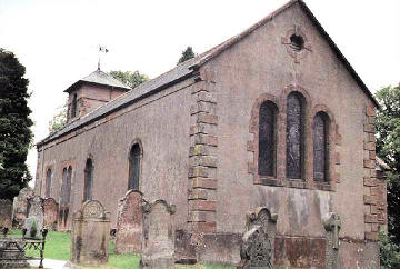
is a small freestone edifice, with a square tower, rebuilt in 1828, at a cost of £250,
raised by a parish rate, save £60 given by the church building commissioners, and a sum
expended by the rector, who built the chancel. The old church, which had long been in a
dilapidated state, was supposed to have been built out of the ruins of an old castle, that
stood upon one of the entrenchments just mentioned; and what makes the tradition probable,
is, there were several broken pieces of carved stones in the walls of the old church. The
benefice is a rectory, in the patronage of the dean and chapter of Carlisle, and
incumbency of the Rev. Thomas Chas. Vaughan. It is valued in the king's books at £5 12s.
10d., but was certified to the ecclesiastical commissioners as of the average value of
£159 per annum. Inscription on the bell taken out of the old tower, "Praise thou the
lord, O castle Carrock !" At the enclosure of the commons, an allotment of land,
which now lets for £12 a year, was set apart for the endowment of a school. On the summit
of the fell are two cairns, one of great magnitude, called Hespeck raise. About the year
1775, a farmer, removing a large cairn of stones, near Gelt bridge, found a human skeleton
in a sort of stone coffin, and it was generally supposed, from the sudden and visible
alteration in his circumstances, that he also found there something of considerable value.
This parish was anciently possessed by Eustace de
Vallibus, who received it from Robert, first lord of Gilsland, in the reign of Henry II,
together with Hayton. It afterwards descended to his sons, when it passed by heiresses to
other families, and subsequently to the Dacres. Tarn Lodge in a handsome villa,
built 40 years ago, by John Bell, Esq., and now the residence of John Nixon, Esq. The Church
is a small freestone edifice, with a square tower, rebuilt in 1828, at a cost of £250,
raised by a parish rate, save £60 given by the church building commissioners, and a sum
expended by the rector, who built the chancel. The old church, which had long been in a
dilapidated state, was supposed to have been built out of the ruins of an old castle, that
stood upon one of the entrenchments just mentioned; and what makes the tradition probable,
is, there were several broken pieces of carved stones in the walls of the old church. The
benefice is a rectory, in the patronage of the dean and chapter of Carlisle, and
incumbency of the Rev. Thomas Chas. Vaughan. It is valued in the king's books at £5 12s.
10d., but was certified to the ecclesiastical commissioners as of the average value of
£159 per annum. Inscription on the bell taken out of the old tower, "Praise thou the
lord, O castle Carrock !" At the enclosure of the commons, an allotment of land,
which now lets for £12 a year, was set apart for the endowment of a school. On the summit
of the fell are two cairns, one of great magnitude, called Hespeck raise. About the year
1775, a farmer, removing a large cairn of stones, near Gelt bridge, found a human skeleton
in a sort of stone coffin, and it was generally supposed, from the sudden and visible
alteration in his circumstances, that he also found there something of considerable value.
Geltsdale Forest is an extensive tract of mountain, forming the south-east portion of the parish, and is a royal forest, leased by the earl of Carlisle. Part of it abounds in birch and alderwoods, and gives rise to the river Gelt, which flows northward. Previous to the dissolution, both this and the adjoining forest of Brierthwaite belonged to the priory of Hexham, but after the suppression of that house, were granted to the barons of Gilsland.
Mannix & Whellan, History, Gazetteer and Directory of Cumberland, 1847