Bustabeck is a township of scattered houses, 4½ miles N.E. of Hesket New Market1, and eight miles S. of Carlisle, contains about 250 inhabitants, and 1789 acres of land, at the rateable value of £1053.
How-bound contains about 210 souls, 1632 acres of land,
of the rateable value of £833, several dispersed dwellings, and the hamlet 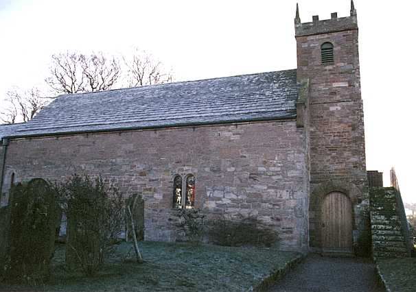 of How-hill, nine miles N.W. of Penrith. The parish church,
which is dedicated to St. Kentigern, is situated in this township, and is an ancient
edifice, consisting of a nave, with a porch on the south side, and a chancel. The living
is a vicarage, valued in the king's books at £17 10s. 5d. and now worth about £100 per
annum. In 1294, John Baliol, king of Scotland, presented William de Londons to this
living, which was then a rectory; in the same year, Anthony Beck, bishop of Durham,
presented it to John de Langton, lord high chancellor of England, and afterwards bishop of
Chichester; both have been designated as "singular presentations." In 1307,
Edward I granted the advowson of this church to the prior and convent of Carlisle, and the
appropriation of the revenues to their own use: after the destruction of the monasteries,
the dean and chapter of Carlisle became appropriators and patrons, and the Rev. Joseph
Taylor is the incumbent. A modern writer makes the following remarks on the venerable
parish churches of the kingdom - "Since these churches were first built, the deep
foundations of ten thousand castles and mansions have been laid, and again dug up and
scattered abroad, yet the very wood-work and the ornaments of those simple records of our
forefathers piety still survive." In their different styles of architecture,
"they carry the mind backwards through the vista of ages; they give it a momentum
forward into futurity; they are an emblem of perpetuity; they present to us the church of
all times; they bring before us different generations as so many independent witnesses to
the truth."
of How-hill, nine miles N.W. of Penrith. The parish church,
which is dedicated to St. Kentigern, is situated in this township, and is an ancient
edifice, consisting of a nave, with a porch on the south side, and a chancel. The living
is a vicarage, valued in the king's books at £17 10s. 5d. and now worth about £100 per
annum. In 1294, John Baliol, king of Scotland, presented William de Londons to this
living, which was then a rectory; in the same year, Anthony Beck, bishop of Durham,
presented it to John de Langton, lord high chancellor of England, and afterwards bishop of
Chichester; both have been designated as "singular presentations." In 1307,
Edward I granted the advowson of this church to the prior and convent of Carlisle, and the
appropriation of the revenues to their own use: after the destruction of the monasteries,
the dean and chapter of Carlisle became appropriators and patrons, and the Rev. Joseph
Taylor is the incumbent. A modern writer makes the following remarks on the venerable
parish churches of the kingdom - "Since these churches were first built, the deep
foundations of ten thousand castles and mansions have been laid, and again dug up and
scattered abroad, yet the very wood-work and the ornaments of those simple records of our
forefathers piety still survive." In their different styles of architecture,
"they carry the mind backwards through the vista of ages; they give it a momentum
forward into futurity; they are an emblem of perpetuity; they present to us the church of
all times; they bring before us different generations as so many independent witnesses to
the truth."
Near the church is Castle Hill, from whence, Sowerby has probably taken the name of Castle Sowerby. Spacious roads have been cut in the rock leading to the summit of this hill, in which is a large circular cavity, 18 yards in diameter, and having a narrow entrance, where iron crooks show that it was shut up in times of danger, perhaps to secure the cattle against the Borderers.* The hill is part of one of the ten estates in the parish anciently called Red Spears, on account of their tenants holding them by the singular service of riding through Penrith on Whit Sunday, brandishing their spears as a challenge to the enemies of their country, or those who dared to dispute the title of the lord of Inglewood Forest, similar to the parade of the Champion of England. Those who held by this tenure were of the order of Red Knights, mentioned in our law books. "Debent equitare cum domino suo de manerio in manerium vel cum domini uxore.2" Their spears were about nine feet long, and till within the last century, some of them remained in the proprietors' houses, where they were usually deposited, and were sureties to the sheriffs for the peaceable behaviour of the rest of the inhabitants. Sowerby Common anciently abounded in oak wood; on breaking up of the land, a great number of pit-steads were found, where the wood had been reduced to charcoal; similar appearances have been discovered in Broadfield Common. On the crown of How Hill is a circular enclosure, mounded with stone and earth, about 21 yards in diameter, with an opening on the south side.†
Row-Bound, commonly called Sowerby Row, about 2 miles N. of the church, contains several detached dwellings, 1384 acres of land of the rateable value of £499 10s. and a population of 120 souls. Here is a school, at which ten free scholars, belonging to the How, Row, and Sowerby Bounds, were educated for two rent charges £5 a year, bequeathed by John Sowerby and Mrs. Cookson, but we have been informed that the former is lost, consequently only five scholars are now taught free. The Revd. James Clarke, vicar, who died about the year 1739, left £25, and directed the interest to be distributed amongst the most industrious poor families of the parish; he also left the further sum of £30, the interest to be laid out yearly in the purchase of bibles and testaments, to be given to the poor. There were two other charities belonging to the parish, viz., Barker's Gift, and the Rev. Joseph Sevithwaite's bequest, but both have been lost.
Southernby Bound lies about two miles east of Hesket-New-Market, and contains about 170 souls, and 1530 acres, of the rateable value of £690 10s. Southernby House is the residence of Mrs. Fallowfield, widow of Mr. John Fallowfield3, who was author of various miscellaneous essays and poems. Most of the buildings stand upon what was called the Town-green, and command a beautiful prospect.
Stockdalewath4 Bound contains the neat but straggling village of Stockdalewath, and part of Raughton-Head, and is distant about eight miles south of Carlisle, lying next to Dalston parish, between the Caldew and Roe, or Raw, rivulet. It contains about 270 souls, and 1570 acres, of the rateable value of £967. Thackwood Nook, the pleasant seat of Wm. Blamire, Esq., chief commissioner of taxes, is situated in this township, and near to it is Thistlewood, the seat of Mrs. Wilson. Within a quarter of a mile of the village is the site of a large Roman entrenchment, 188 yards long and 160 broad, having an inward and an outward vallum, within which stones and ashes have been found, but no inscriptions, bones, or urns. At the S.W. end of Broadfield, within a mile of these camps, are traces of a Druid's Temple5, where the earth has been raised up in a circular form, with a sloping bank of 12 feet, and an area of 63 feet in diameter. There was also a large rocking stone, about 165 yards S., 23 feet 9 in. in circumference, and supposed to have been nearly a ton weight, but no remains of it are now left.
Raughton Head6 is a small
village of good houses on an eminence, within the bounds of Stockdalewath and Bustabeck,
seven miles 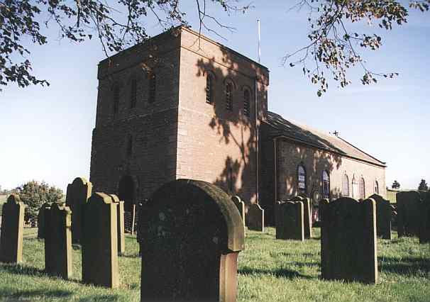 south of Carlisle. Here is a chapel of ease, which,
after lying a long time in a ruinous state, was rebuilt in 1678, and consecrated by bishop
Rainbow; it was again rebuilt in 1760, at an expense of above £300. The ancient chapel is
said to have been so homely an edifice that it was thatched with fern, but it is now neat
and commodious; and in 1842, Mr. Rbt. Barker, of Stockdalewath, presented it with a barrel
organ, playing thirty tunes. The nomination of the curate is in the vicar of the
parish and twelve trustees, who are regularly chosen by a majority of the inhabitants of
the chapelry, which includes the two Bounds just mentioned. The ancient salary was
about £3 a year, but it was augmented by £200 of Queen Anne's bounty in 1737, and
subsequently with the like sum from the same source, and £200 from the countess dowager
Gower, so that the present curate, the Rev. John Kitching, has an income of about £100
per annum. Adjoining the chapel yard, Mr. John Head, of Foxley Henning, erected a school,
in 1744, and in 1762 the Rev. Joseph Sevithwaite, the vicar, bequeathed to it £20, which
has been lost; as also has the interest of another £20, left by him to be given yearly in
books, to the poor.
south of Carlisle. Here is a chapel of ease, which,
after lying a long time in a ruinous state, was rebuilt in 1678, and consecrated by bishop
Rainbow; it was again rebuilt in 1760, at an expense of above £300. The ancient chapel is
said to have been so homely an edifice that it was thatched with fern, but it is now neat
and commodious; and in 1842, Mr. Rbt. Barker, of Stockdalewath, presented it with a barrel
organ, playing thirty tunes. The nomination of the curate is in the vicar of the
parish and twelve trustees, who are regularly chosen by a majority of the inhabitants of
the chapelry, which includes the two Bounds just mentioned. The ancient salary was
about £3 a year, but it was augmented by £200 of Queen Anne's bounty in 1737, and
subsequently with the like sum from the same source, and £200 from the countess dowager
Gower, so that the present curate, the Rev. John Kitching, has an income of about £100
per annum. Adjoining the chapel yard, Mr. John Head, of Foxley Henning, erected a school,
in 1744, and in 1762 the Rev. Joseph Sevithwaite, the vicar, bequeathed to it £20, which
has been lost; as also has the interest of another £20, left by him to be given yearly in
books, to the poor.
* Hutchinson
† Mr. Sewell, in Hutchinson
Mannix & Whellan, History, Gazetteer and Directory of Cumberland, 1847