THE famous Roman or Picts wall, as it is also called, being erected as a barrier to prevent the savages of the Caledonian Britons, was first formed by Adrian1, A.D. 121, of earth, with a large ditch; but this barrier being found insufficient to check the fury of the valiant but uncultivated sons of the north, Severus built one of stone: this fortification extended from Tinmouth2 in Northumberland, to the Solway Frith3 in this county, and divided the kingdom from sea to sea; at proper and convenient distances castles or towers were built upon this immense wall to protect the country, and carry intelligence from the one end of the wall to the other. The legendary soldiers of the Romans were employed in erecting this wonderful piece of architecture, the remains of which may still be traced for 70 miles and will long continue a monument of the consummate skill and perseverance at that brave and formidable people.
The last Roman station in Northumberland is Carr-Voren, the Magna of the Romans. From hence the wall passes down to the river Tippal4, where considerable remains of it are to be seen. Leaving Thirlwall castle to the north, at which place it is said the Picts broke through, it passes the little brook Pottras5 and enters CUMBERLAND.
On the west of that river are the remains of a castellum. Following the course of the wall across the Irthing, we come to Birdoswald, (Ambovlana) which was garrisoned by the cohors prima Ælia Dacorum. The distance from Carr-Voren is 2¾ mile, and in this space are visible three castella. A great number of inscriptions have been found here; most of them have been carried away, but several of them are in the possession of Mr. Bell, of Gilsland, whose collection of them and other monuments of antiquity is accounted very valuable.
The distance of this from the next station, called Cambeckford, or Cast-steads, the Petriana at the Romans, is 6¼ miles; in this tract of ground the vestiges of seven castella are observable at equal distances: the wall of Severus is pretty distinct; at many places the facing stones are to be observed6. Near Wallbours7, it is of a good height, and is passed by the military road. Crossing the brook called Bankhill-burn, the ruins of the wall attain a considerable height, but it is here without facing stones. Near Binkshaw Severus's wall takes a sweep, going over the summit of the hill; and at High-will-town all the works are obscure.
Castlesteads lies about 400 yards south of the wall. The Ala-Petriana was situated here, and the ruins of the wall are pretty distinct. Mr. Johnston, in making his improvements upon the site, discovered many antiquities, which are carefully preserved at Walton House. Several antiquities, as coins, &c. had been previously found.
Hence to Watchcross is a distance of three miles, and in this space as many vestiges of castella are observable; and the site of a fourth was to be seen some years ago. The state of the wall here is various: from Cambeck-hill to Irthington it may be traced in various parts; at Old Wall the several works may be discovered; between that place and Bleatarn, at Housesteads8, an altar was some time ago discovered, but without inscription. - In the Notitia Watchcross is called Aballaba, and held a detachment stiled numerus Mansorum: it is on a dreary waste. A little south of the wall several inscriptions have been found. Near Bleatarn, it passes through a morass.
From Watchcross to Stanwix, distant about five miles, the works go through a fine cultivated country. Not more than two castella are to be traced within this distance; the intermediate ground allowing space for three more, now totally destroyed. Between Tarraby and Stanwix, the foot-path is on the foundation of the wall; and a few years ago, Mrs. Graham, of the former place, dug up a very perfect Roman altar among the foundation stones of the wall, while cutting a drain. The following is the inscription:
MART. COC M
LEG.II AVG
SANCTA.NA
SECVNDINI
.D.SOL.SVBCv
R A.ÆLIANIe
T
CVRA.OPRV
I
FELIX.OPTO
We acknowledge our obligations to Mr. Isaac Stockdale, of Bishop's Lough, for the following reading and translation:
MARTI COCIDEO MAGNO, LEGIO SECUNDA AUGUSTA SANCTA SUB CURA ÆLIANI DUCIS SOLIUS NUMERI SECUNDINI 0PPIUS FELIX OPTIO, DEDICAT PONENDUM CURA.
TRANSLATION.
"The second sacred Augustine Legion, under the charge of Ælianus, commander-in-chief of the second Legion, Oppius Fælix being his Deputy Lieutenant, dedicates this altar to Mars, the great local deity; to be set up with care."
Stanwix, the Congavrata of the Romans, as is evident from the inscriptions found here, was garrisoned by the cohors secunda legorum. Severus's wall has formed the north rampart of the station, and stretched through the gardens of the village. The ditch is distinctly to be traced from the west end of the place to the river's banks; and the ridge which the wall has left is pretty eminent in many places, and may be accurately traced to the very brink of the precipice over the Eden. At Hissop-holm-well at the bottom of a precipice on the margin of the river, not less than 100 perpendicular feet in height, some remains of the wall are yet to be seen; and the fishermen have frequently pulled up large stakes from the bottom of the river, which were entangled in their nets. Tradition also records, that a wooden bridge passed from Stanwix to the Castle bank opposite, in the wall of which fortress there has been a gateway now closed up.
The next station upon the line of the wall is fixed by the best antiquarians at Burgh, which is said to be the Axelodunum of the Romans, and had the prima cohors Hispaniorum in garrison for some time:- it is distant from Stanwix about five miles. The foundation of the wall, after crossing the river at Stanwix, is easily traced along Davidson's banks, below Newtown; on the side of the road between Newtown and Kirkandrews, Severus's wall is very visible, as also Adrian's, about a furlong to the south of the former, upon the common. From Kirkandrews to Wormanby and to Burgh it is also visible. At the former place a Roman altar was dug up, and is now in the possession of Mr. Norman, of that place. At the latter place, the station is a little to the east of the church, near to what is called the old castle. - ln 1792, Mr. Wilson, of Burgh, in cutting a drain at Hallstones, found a small altar, dedicated to Belatucader, the Mars or Apollo of the Britons.
Severus's wall passed on the north side of Burgh by the edge of the marsh to Longburgh; thence to Drumburgh, where some antiquities have been discovered. The site of the station is very distinct here, but whether Adrian's ditch proceeded further is doubtful. The wall is very conspicuous at a small distance from Drumburgh to the west, and continues the greatest part of the way to Bowness, but no facing stones remain above ground.
Bowness, Blatum, Bulgium, Gabrosentum,
or Tunnocellum, where the cohors prima Ælia classica was stationed is
the last station on the wall. The village now occupies the sight, but there are traces of
the vallum and outworks: several Roman antiquities have been found here*.
Having thus gone to the furthest western limits of this stupendous monument of antiquity,
we shall notice the remaining Roman stations in this county. We proceed to Maryport,
situated on a rising ground. At the northern extremity of the town are the ruins of a
large Roman station, surrounded with double ditches, and commanding an extensive view of
Scotland. Antiquarians differ respecting the ancient name: by one it is called Olenacum,
by another Virosidum, and Camden esteems it the Volantium. Military
roads led from it to Morresby, Old Carlisle9, and towards
Ambleside. - lt has been, in fact, a perfect magazine of Roman antiquities. Mr. Senhouse,
of Nether-Hall, has taken great pains in exploring this station, and his exertions have
been rewarded by a large collection of sculptures, inscriptions, coins, &c.
The next station is Morresby, according to Horsley the Abeia of the Romans, and which is west and south-west of the church, close to the sea. The numerus Barcariorum Tigritensium was in garrison here; several inscriptions have been found, but they are mostly dispersed. - Old Carlisle, (about one mile south of Wigton) called Caer-Leol, is the Alenacum of the Romans, where was garrisoned the ala Herculea. The remains of this station are situated on an easy ascent, commanding an extensive prospect towards the Frith and Scotch borders. They are very extensive, the foundations being scattered over many acres. Sacrificial instruments, altars, coins, &c. have been found here in considerable numbers.
We now cross the country to Old Penrith, (the Bremetenacrum according to Horsley, and the Petriana of Camden) about five miles north of Penrith. The Roman road leading to the wall went close by this place, and was twenty-one feet in breadth. The remains of this station are distinctly observable: the ground within it has been levelled, and consists of about three acres. As in other similar situations great quantities of sculptures, &c. have been recovered. - We now traverse the country northward to Bewcastle; which, there is strong reason to conjecture, has been a Roman station, since a ditch of considerable depth is yet to be scene, as also the remains of a lofty vallum, in the area of which the castle, church, burying-ground, and parsonage are situated. Tesselated pavements, coins, and altars, have been dug up in this place and in the neighbourhood; and it is supposed to have been garrisoned by part of the legio secunda Augusta. A Roman road intersected this parish, which communicated with the station and likewise With Netherby.
The latter place is supposed by Camden to have been the Æsica, where the tribune of the first cohort of the Astures was in garrison. Pennant calls it the castra exploratorum of Antoninus. Be this as it may, every thing indicates it to have been a fixed residence of the Romans. A fine hypocaust, or bath, altars, inscriptions, utensils, coins, &c. are preserved by Sir James Graham, Bart. of Netherby, who very politely permitted us to take drawings, which were given in the History of Cumberland; and to which we refer the curious reader for a fuller account, not only of this, but of all the antiquities of the county.
Since, however, the publication of the History of Cumberland, several coins, &c. have been discovered in different parts. But the most elegant and curious specimen of ancient art known in Cumberland, are two sacrificial Roman vases discovered in Carlisle in the year 1804, while digging a well in Scotch-street. They were disposed of to the late Mr. Townley, the antiquarian, and are now preserved in the British Museum. The name of this kind of vase is generally distinguished by præfericulum, and is understood to have been appropriated to holding the incense, &c. The metal of which the vases in question are formed seems to be a composition of refined brass. The sculpture of these vases consists of four groups of figures, in excellent workmanship, illustrative of sacrifice. The uppermost seems to be two people holding, or preparing, a cow or bullock for sacrifice; the next a person taking hold of a bear for the same purpose; the third, a priest clothed in his robes, standing at an altar, holding something on it; on the one side of the lower one, is a man in complete armour, holding a knife as if going to immolate a sheep or lamb, which another person below holds up for that purpose: on the other side the priest stands, with another knife or sword, attending the ceremony. - We believe the vases we are speaking of are the first of the kind discovered in Britain.
A very curious Roman sandal was dug up,
while sinking a well, a few years ago. It is calculated for a child's foot, and the
workmanship is truly elegant. - It is now in the possession of John Losh, Esq, of
Woodside. - Miss Carlisle, of this city, has, a pretty good collection of antiquities, and
there are many detached pieces belonging to individuals; among others a British or Roman
hand-mill stone, now in the possession of the Editors of this work, found in sinking the
foundation of a house in the Old Turk's
Head-lane. To mention them all would fill a volume.
* In order to convey a more perfect idea of the Roman Wall, it may be proper to give some further information.
This grand work originated with Agricola, the celebrated Roman General, who formed a rampart, which consisted of a ditch three of four feet in depth and as many in width. From this a bank rose, ten feet high, and thirty feet thick at the base. This height, including the depth of the ditch, gives a total rise of 13 or 14 feet. The opposite side of the bank sank into another ditch that was 10 feet deep and 15 wide; which gives the north side a declivity of 20 feet. A part of the soil thrown out of this latter ditch, on the north side, formed another bank three feet high and six broad, making an elevation, from the bottom of the ditch, of 13 feet.
Adrian's works generally joined those of Agricola. Close
to the north side of the smaller mound, last described, that Emperor sank a ditch 24 feet
in width and 12 in depth; which being added, Agricola's smaller bank now formed a
declivity of 15 feet to the south and 12 to the north. Then succeeded a space of level
ground, 24 yards over, and a bank exactly similar to Agricola's, being 10 feet high and 30
broad at the base. He then finished, as his predecessor began, with a small ditch of three
or four feet. - The annexed cut exhibits the two works viewed in profile.
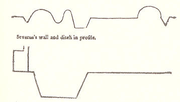
The works of Severus ran nearly parallel: the other two lie on the north, never far distant, running on a course that suited the judgement of the planner; - the nearest distance about twenty yards - the greatest nearly a mile - medium distance forty or fifty yards. Severus's works consisted of a stone wall eight feet thick, twelve high, but, including the battlements, sixteen feet in height, - with a ditch to the north, thirty-six feet wide by fifteen deep. To this wall were added, at unequal distances, a number of stations or cities, said to be eighteen in number, eighty-one castles, and 330 castelets, or turrets.
Exclusive of all these, Severus constructed a number of roads, yet called Roman Roads, twenty-four feet wide, and eighteen inches high in the centre, which formed a communication from turret to turret, from one castle to another; - and still larger and more distant roads to lead to and from the respective stations. There was besides a grand military way, which covered all the works; and on the site of it, in most places, the present military road was formed in 1752. There were also other roads branching out to the different fortified cities, twenty or thirty miles distant, - so that throughout the whole country was a continued series of fortifications.
Jollie's Cumberland Guide & Directory 1811