Read at a Meeting of the Glasgow Archeogical Society held an 13th November, 1896.
I. FROM AGRICOLA TO ST. CUTHBERT
1. THE ROMAN ADVANCE.
Until the thirteenth century there is scant record of the great estuary which, dividing Dumfriesshire and Galloway from Cumberland, was so well fitted by nature to form part of an international frontier line. Of pre-Roman times there is, of course, no human record at all except in the canoes occasionally found in the great mosses(1) which hem in the east end of the firth, and occupy ground once covered by the sea.
"Once a wood and once a sea,
Now it's a moss, and aye shall be,"
is the local rhyme of Lochar Moss(2)
 The Roman record is filled with uncertainties. The geography of
Agricola's campaigns, as described by Tacitus(3) is
too confused to admit of definite conclusions regarding the estuary - usque ad Tanaum
(aestuario nomen est) - which he reached in A.D. 80, and which some commentators(4) have believed to be not the Tay, as generally
assumed, but the Solway. There is a consensus of learned opinion, however, that Ptolemy(5), in his mention, nearly a century later than
Tacitus, of the estuary of the Itouna, of the outlet of the Novius, and of the outlet of
the Deva, alluded to the Eden, the Nith, and the Dee, all rivers flowing into what we now
denominate as the Firth of Solway. The consonance between the estuary of Tana and the
estuary of Itouna has not hitherto attracted much attention, but may be commended to the
students of the Roman occupation. There is no evidence that the Romans gave the name in
question to the entire arm of the sea. Itouna, if synonymous with Eden, was evidently a
name confined to the upper end of the Solway, as, indeed, the term "estuary of the
Eden" is to this day. The precise original meaning of Solway is a matter for future
examination: it is enough meantime to note that the word was unknown to the Romans.
The Roman record is filled with uncertainties. The geography of
Agricola's campaigns, as described by Tacitus(3) is
too confused to admit of definite conclusions regarding the estuary - usque ad Tanaum
(aestuario nomen est) - which he reached in A.D. 80, and which some commentators(4) have believed to be not the Tay, as generally
assumed, but the Solway. There is a consensus of learned opinion, however, that Ptolemy(5), in his mention, nearly a century later than
Tacitus, of the estuary of the Itouna, of the outlet of the Novius, and of the outlet of
the Deva, alluded to the Eden, the Nith, and the Dee, all rivers flowing into what we now
denominate as the Firth of Solway. The consonance between the estuary of Tana and the
estuary of Itouna has not hitherto attracted much attention, but may be commended to the
students of the Roman occupation. There is no evidence that the Romans gave the name in
question to the entire arm of the sea. Itouna, if synonymous with Eden, was evidently a
name confined to the upper end of the Solway, as, indeed, the term "estuary of the
Eden" is to this day. The precise original meaning of Solway is a matter for future
examination: it is enough meantime to note that the word was unknown to the Romans.
With the firth itself they were perforce made familiar. Their northward march lay through the territories of the great tribe of the Brigantes, a turbulent race in possession of Cumberland and the whole north of England. When Agricola reached the Solway he found that on the other side of it there dwelt the Selgovae, occupants of Dumfriesshire and Galloway. They were probably akin to the Brigantes in blood and religion, as well as in their warlike proclivities.
The geography of Agricola's Caledonian
campaigns is too indistinct to dogmatize upon, and one cannot follow our great antiquary,
George Chalmers, in his conclusions(6) that
Agricola sailed up the firth, landed at the mouth of the Lochar, marched up the Nith for
some distance, and then crossed into Galloway. It was, however, Tacitus assures us, only
by many battles that Agricola "subdued that part of Britain which looks over at
Ireland."
2. UNDER ROME
When Rome fairly settled herself in Britain,
and her frontier system came to be adjusted, the firth formed such an outstanding natural
line that it beyond a doubt formed the dominating consideration in determining the
direction and place of the great barrier thrown across the island from sea to sea. Opinion
is still far from settled with regard to the date and even the purpose of the Vallum and
the Murus [i.e. Hadrian's Wall], which extended from Bowness on Solway to Wallsend on
Tyne. The view of Dr. Collingwood Bruce, that the entire works are of one date and one
purpose, has practically left the field, and the modern tendency appears to be setting
towards the belief that the Vallum, an earthwork consisting of a fosse with a rampart on
each side of it, and a marginal mound for long distances on the south side in addition,
was antecedent to the Murus, the latter being a stone and lime wall with a fosse in front
of it. All questions of date are vague. Probably the original Vallum, a limes or
boundary(7), with a defensive object subordinated,
was thrown up in the time of Hadrian, followed later, though perhaps not much later, by
the Murus, a powerful fortified line. Camden(8) had
sound Roman authority behind him when he said that the Wall was put up to keep out the
"Barbarians, who in those parts were continually barking and snarling at the Roman
Empire." The western extremity of the Vallum was at Dykesfield, near Burgh by Sands;
that of the Wall was further west at Bowness. The meaning of this great work may be taken
to be that, when it was planned, the Romans had decided if not to leave the region north
of it to the Picts, at all events to concentrate their efforts upon strengthening their
defences so as to secure themselves in the territory to the south. When Roman conquest
held, or aimed at holding, Caledonian territory beyond, the Solway is thought to have
formed part of the dividing line(9) between the
provinces of Valentia on the north and Maxima Caesariensis on the south of the Wall.
3. AFTER ROME.
By the departure of the Romans in the fifth
century the Romanized Britons were left to guard themselves as best they might behind the
splendid rampart which the Romans had built. But no sooner were the Romans gone than, as
Gildas(10), the Jeremiah of British chronicle,
tells with indignant eloquence: "Foul hordes of Picts and Scots, like tawny worms
coming forth in the burning heat of noon out of the deepest recesses of their holes,
hastily land from their curraghs in which they had crossed the Tithican Valley(11); differing in manners, but all sharing the same
thirst for blood, and more eager to shroud their villainous faces with beards than to
cover with decent clothing those parts of their bodies which required it." These
bearded men with kilts, who sailed up the Solway, soon effaced the Roman Wall as a
boundary, and in the chaos of the ensuing four or five hundred years it cannot be said
that even the estuary remained a constant division mark of race or realm. There were Picts
in Galloway and Britons in Cumbria or Strathclyde, the latter a province stretching north
to Dumbarton, and south into Lancashire, if not right down into Wales. In the sixth
century comes the news of the first great battle(12)
fought in the vicinity. At Arthuret on the Esk, in the year 573, Rhydderch of Cumbria, a
Christian, overcame the pagan Guendoleu. St. Ninian, supposed to have been a native of the
district, raised that first of all stone churches in Scotland, worthier of veneration than
Iona itself, that little white building, of which there is good reason to hope(13) some portions yet remain. It stood on the shore
of what one copyist of Gildas called "the Sea of Galloway."(14) St. Mungo, whose first seat in Scotland as
bishop was at Hoddom in Annandale, followed in sowing the seeds of Christianity on the
Solway shore. Already when he came there was a great admixture of races amongst the
inhabitants - Picts and Britons having now the Angles in the very midst of their
territory. The number of dedications of churches in Galloway, Dumfriesshire, and
Cumberland to St. Mungo(15) and St. Cuthbert,
equally with the historical connection of these saints with the whole district, and the
probable community of Celtic feeling pervading it, shows that the religious conquest of
those regions had been accomplished about the same time and by the same instrumentality.
St. Mungo's diocese of Glasgow was co-extensive with the province of Cumbria.
II. GEOGRAPHICAL: THE ORIGINAL SOLWAY.
4. SOLWAY AND SELGOVAE
In spite of repeated alterations of the international boundary line, now at the estuary itself, now north of it, now south, it is not till the thirteenth century that the name of Solway comes distinctly forward. Thenceforth it has an enduring place in international history, vouched by many references in chronicle, border law, and charters. It is becoming that in the light of these documents we should search out the origin of the name. It may surprise some to learn that one of the first matters for consideration is whether the Solway proper was an arm of the sea.
Three hundred years ago Camden said(16) in his Britannia that the estuary "is called by both nations Solway Frith, from Solway, a town of the Scots that stands upon it." At another place in his great work he informs us that the village of Solway stands near the mouth of the Nith(17). I have looked very diligently for traces of this village of Solway on the Nith, but after a careful examination of maps, books, and charters, I can find no such village except in Camden's book and his map of Scotland, on the maps of Scotland according to Mercator and Ortelius(18) (where perhaps Camden obtained his information), and on John Speed's map(19) which, if I mistake not, like Camden's, follows Mercator and Ortelius. Camden and all the map-makers were wrong; there never was a village called Solway on the Nith at all.
English antiquaries, from the venerable Beda
[Bede] downwards, have with varying degrees of zeal, sanity, and success dabbled in the
philology of place-names. Camden, no exception to the rule, proceeds to speculate(20) on the source of the word Solway, which, he
concludes, "still retains somewhat of the old name of Selgovae." The view is
endorsed by Christopher Irvine in his curious work on Scottish Historical Nomenclature,
published in 1682, wherein he says(21) the Solvoeus
or Solway Firth "hath its denomination from the old people Selgovi." The
proposition thus first enunciated by Camden that the name of this ancient race had clung
to the firth on the shores of which they dwelt, and was thus a survival attesting their
existence in these parts, was implicitly accepted by many subsequent writers. Indeed it
passed for a time as an axiom with authorities on place-names(22).
Nevertheless, the word has nothing whatever to do with the Selgovae.
5. THE THIRTEENTH CENTURY SOLWAY.
When the name first occurs in thirteenth century documents, it is almost invariably mentioned with the preposition "at" prefixed. Only by straining the natural sense of that expression can it be forced into keeping with the idea of the Solway being regarded as the name of an estuary or a river. We say "at Annan," because we mean the place and not the river: we do not say "at Nith." Neither could thirteenth century clerks have written "at Solway" without meaning something very definite and very different from "at the Solway Firth." Many meetings took place apud Sulewath, at Solway. Thus Reginald, King of the Isles, was to be met(23) in 1218 "at Sulewad." The Statute of Marches(24) in 1249 enacts that the proper tribunal for the trial of offences against the border laws was "at Sulewath," or, as another manuscript has it, "at Sulway." There was an appeal(25), in 1280, concerning one of these trials "at Solewathe." Finally, in legal proceedings of date 1292, there is descriptive mention(26), as the peculiar West March place of justice, of "a certain place called Sulwat at the marches of the realms." The march laws(27) of 1249 point to a closer localization of the spot, for they refer to the driving of cattle across the river Esk as an incident of the trial in certain cases of disputed ownership. About 1275 it is mentioned in a connection(28) which places it clearly on the most direct line of road into Scotland from the south. In the accounts(29), of the campaign of Edward I., in 1300, it is mentioned as the ford at Sulwath, transitus apud Sulwath. The evidence of the thirteenth century, therefore, sets forth a number of propositions which the course of subsequent history amply confirms. These are:
1. That Sulewad, Sulwath, or Solway, interpreted by the earliest allusions to it, did not denote an arm of the sea, did not indeed denote even a river, but was a distinctly limited locus, a point or place(30) upon a river.
2. That it was a meeting-place for the administration of border law.
3. That it was a place where the English escort might meet a royal visitor passing into England.
4. That it was on the marches of the realms.
5. That it was on the river Esk.
6. That it was already recognized as a regular crossing place.
These facts lead to an induction as little
open to question as themselves, namely, that the original Solway was a ford across the
mouth of the Esk.
6. ETYMOLOGICAL AND HISTORICAL DETAILS.
 When the assistance of fourteenth century records is invoked it is
demonstrable that there were three leading fords - one from Annan to Bowness, still known
as the Annan or Bowness Wath, and styled vadum Anandiae by the chronicler
Knighton(31); another opposite Dornock, known as
the Dornock Wath, but more anciently as the Sandywathe(32);
and the third and chief of them all, at Eskmouth, known as the Solewath, Sulewad, or
Sulwath, a word which easily explains itself. Sol is a term, common to
Anglo-Saxon and to the Norse languages, for mud. Anglo-Saxon woeth - Norse vad
or vath, a frequent suffix in Icelandic local names - is a word for ford. Sulewad
or Sulwath means therefore the muddy ford.(33)
When the assistance of fourteenth century records is invoked it is
demonstrable that there were three leading fords - one from Annan to Bowness, still known
as the Annan or Bowness Wath, and styled vadum Anandiae by the chronicler
Knighton(31); another opposite Dornock, known as
the Dornock Wath, but more anciently as the Sandywathe(32);
and the third and chief of them all, at Eskmouth, known as the Solewath, Sulewad, or
Sulwath, a word which easily explains itself. Sol is a term, common to
Anglo-Saxon and to the Norse languages, for mud. Anglo-Saxon woeth - Norse vad
or vath, a frequent suffix in Icelandic local names - is a word for ford. Sulewad
or Sulwath means therefore the muddy ford.(33)
There is nothing remarkable in an arm of the sea being called after a ford across it. Wath is a well known word in Cumberland and on the border. In East England it takes the form of Wash(34). The large tidal estuary of The Wash, formerly known as The Washes, possibly owes its title to its many fords, in one of which King John's army was surprised, and his treasure swept away. A ford was apt to thrust itself far more upon the attention of the early inhabitants, was often of more use to some of them than the estuary, and so at times acquired a specific name the sooner. And the proposition that one ford might baptise a whole estuary is curiously exemplified more recently by the Solway itself, for local topographers of last century regarded "Booness Wath" as simply amother name for the firth(35). The story of the Solway for several centuries will ever and again illustrate the importance of its once famous original ford, but before attempting to set forth the annals in a chronological sequence it is necessary to adduce further evidence on geography.
Throughout the fourteenth century, despite many allusions to
the Solway (usually as Sulwath or in a closely allied spelling), there is comparatively
little in the references to point decisively to its exact site. There is a singularly
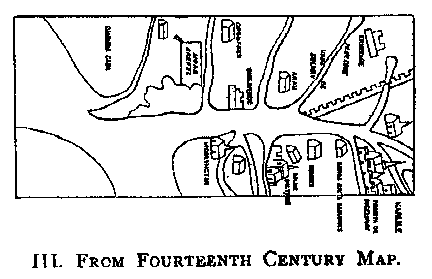
instructive map(36), made in the fourteenth
century, in which the words Vada de Sulway are marked across the river Esk.
Fordun(37) wrote of "the Esk, which is called
Scottiswath or Sulwath." These comments each serve a purpose vaguely. A document of
the year 1307 is much more definite, and in an important sense supplementary to the
evidences already grouped. It is a petition(38) to
Edward II by a person desirous to farm the toll "between Soulwadz and Arturet."
This toll, it is fair to conclude, was that levied from passengers into England. Of this
exaction there is conclusive proof some years later(39).
The two localities named are determinate. Arthuret is obviously, in the mind of the
petitioner, not more a fixed point than Solway. Both must be on the Esk, and Solway cannot
be far from its mouth.
7. THE LOCHMABENSTANE.
The character of Solway as a border meeting-point is seen to be maintained in the fourteenth century by the record of prisoners being ransomed, and of a kind of market being held there(40), a constant characteristic of such assemblies. There are, unfortunately, no documents on the administration of March law on the western border until 1398, when the first of a long series of allusions is made(41) to the Clochmabanestane, afterwards oftener styled Lochmabenstane, as the specific forum for the West March. From 1398 onward the Lochmabenstane plays a large part in border litigation and negotiation. The Warden courts were held there, and generally it may be said that exactly the functions of that sort assigned to the Sulwath in the end of the thirteenth century have, at the end of the fourteenth century, come to belong to the Lochmabenstane.
The position and characteristics of that old stone, therefore, call for close examination. It still stands(42) a few yards above high-watermark on the sea shore, in Gretna parish, a lonely granitic boulder some six feet or so in height, and nine or ten in circumference. It is close to the junction of the Sark and Kirtle with the Esk. Geographically, functionally, and historically it answers at the end of the fourteenth century closely to the characteristics of the "place called Sulwat, at the marches of the realms," a hundred years before. Hence the belief that this is no chance coincidence, but that in very truth the Lochmabenstone marks the Scottish terminus of the great historic ford.
This conclusion, if well founded, must add a
new interest to that old grey stone. Dropped from some iceberg in an earlier geological
period, it lay, when the land emerged from the sea, an unheeded block until the barbaric
piety of some ancient race installed it as the presiding stone of an oval group - the
chief stone of the cluster(43), as its original
Celtic name of Clochmaban possibly means. Or it may mark the grave or be otherwise
associated with Maponus(44), a heathen deity
equated with Apollo, worshipped in Cumberland and Northumberland during the Roman
occupation: or with the memory of Mabon(45), that
vague Arthurian heroic adumbration. Whatever its original connotation(46), we can see that in after centuries the
solemnity inherited from a forgotten purpose clung to it like the mossy verdure around its
base, and it became a fit adjunct of the courts of border justice and the transaction of
grave international business. And if the while, besides all this, it pointed out the great
track across the Solway, one must perceive in it a landmark of extraordinary interest,
past which, in alternate flux and reflux, like the sea beside it, there swept for
centuries successive invasions. In 1296 it saw advance the first battalion in the War of
Independence. In 1449 it gave its name to the battle of Sark, called by contemporaries(47) "the battell of Lochmaban stane." In
any view, its geography(48) requires scrutiny.
8. THE TRUE ORIGINAL SOLWAY.
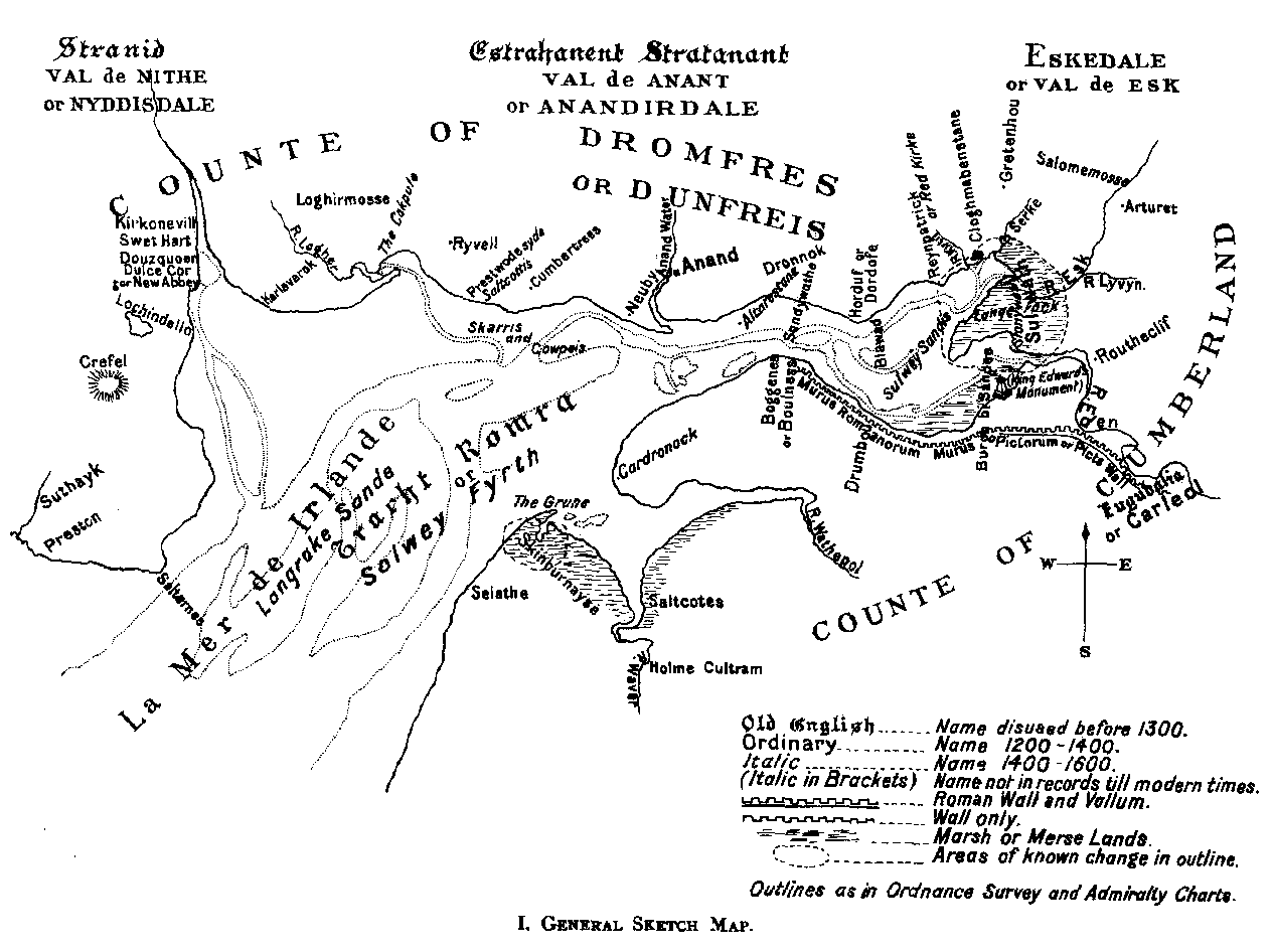
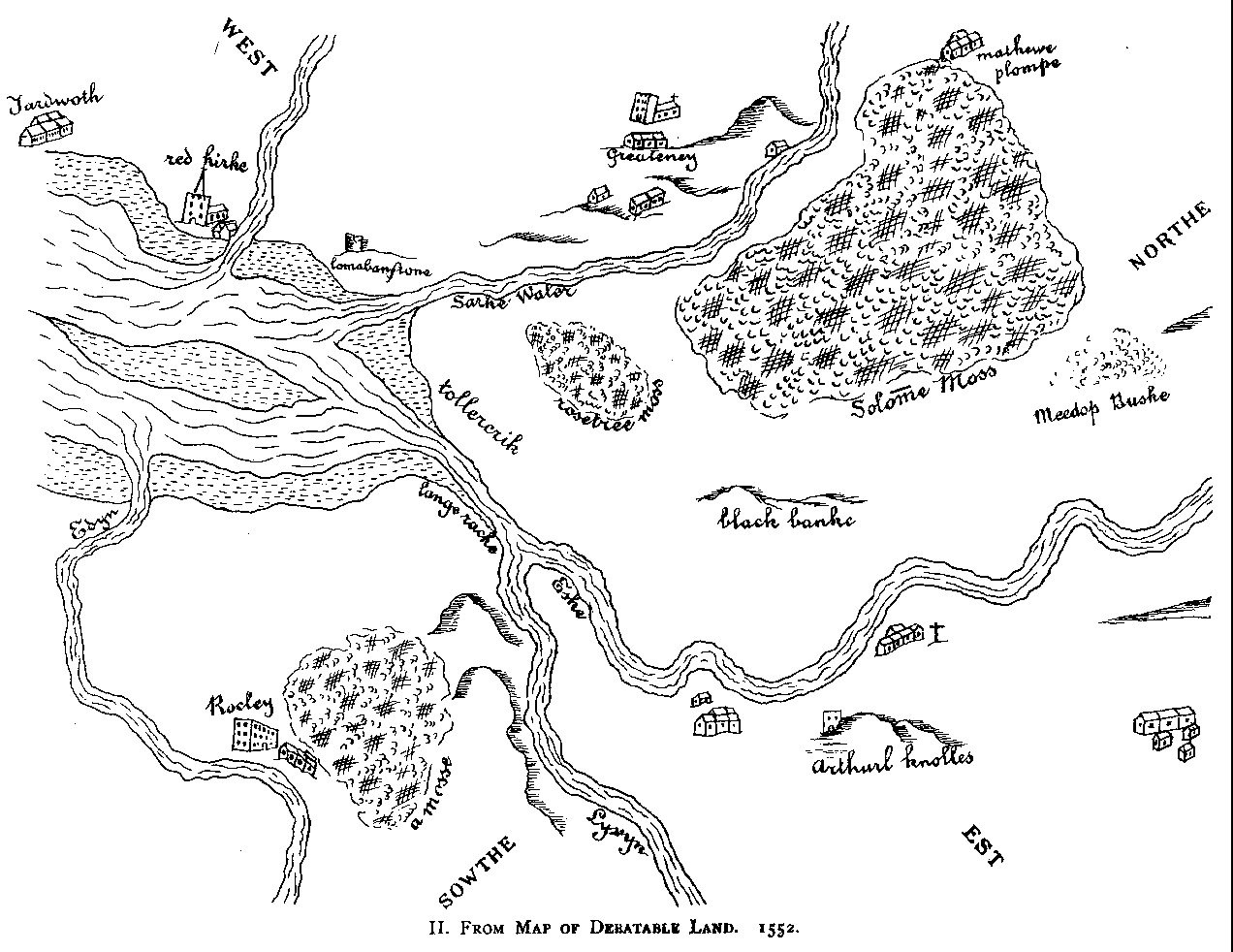
In the suggestion that the Lochmabenstane marked the Scottish end of the ancient ford of Sulwath, there are certain difficulties, which one circumstance not patent to the superficial observer tends materially to lessen. The Solway has been receding for centuries. In Roman times, if we might follow Leland, it would be possible to suppose that the Esk was once navigable as far as Netherby, for he says, "men alyue have sene rynges and staples yn the walles as yt had bene stays or holdes for shyppes." But that is too extravagant. Certain it is, however, that the upper end of the Solway is steadily and rapidly changing, and has long been so. In 1834 the minister of Gretna wrote in the Statistical Account(49) that, near the extremity of the firth, "a large tract of marsh land of a lively green has been formed, and is daily increasing." How great the growth has been since the middle of the sixteenth century will be best seen from a consideration of a series of maps.
 Four rivers flow into the firth at its eastern end. These are the
Kirtle, the Sark, the Esk, and the Eden. To understand the effect of these rivers,
especially the Esk and the Eden, upon the configuration of the land, it is only necessary
to contrast with the present the state of matters represented by the very carefully
prepared map(50) drawn up in 1552 for the
commissioners engaged in settling the division of the Debatable Land. The Lochmabenstane
is boldly outlined; across the estuary is Burgh by Sands; between them are the tidal sands
of Solway; the eastern shore of the estuary, the limit of firm land, lies well to the east
of an imaginary line from Burgh to the Lochmabenstane. Other maps less careful and
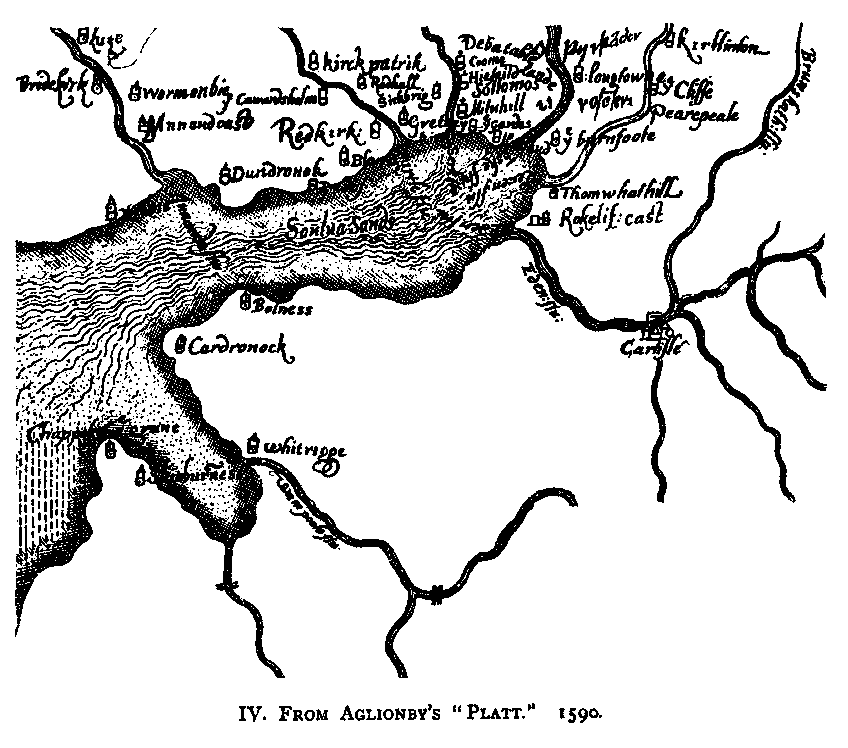
trustworthy than that of 1552 emphasize the same fact. Aglionby's Platt(51) of the Opposite Borders, dated December
1590, represents the shore line curving almost in a semicircle from Sarkfoot to the mouth
of the Eden. Morden's map in Camden's Britannia, with considerable differences,
yet like Aglionby's, carries the firth close up to Rockcliffe. Camden, in his text(52), very exactly says that the Esk and Leven (now
the Line), "with joint streams enter the estuary of Ituna almost at the same
mouth." The change since then is vast: it is over two miles from the junction of Esk
and Line to the point where the united stream falls into the estuary. In 1608 Pont's map
of Annandale shows Rockcliffe Marsh as a small rounded protuberance west of Rockcliffe. In
Crawford's map, engraved for the Atlas Of Scotland (1832), Rockcliffe Marsh juts
far out into the firth, whilst the latest map(53)
(although I am afraid it is not revised to date) shows that extensive growth to have
reached a point not less than two miles west of the limit indicated by the early maps. As
nearly as can be estimated the land line of the old maps was at about 3° 2' 0" west
longitude. When the Ordnance Survey was made it was about 3° 5' 30". A very great
change, but one for which the natural action of the rivers affords a full explanation.
Four rivers flow into the firth at its eastern end. These are the
Kirtle, the Sark, the Esk, and the Eden. To understand the effect of these rivers,
especially the Esk and the Eden, upon the configuration of the land, it is only necessary
to contrast with the present the state of matters represented by the very carefully
prepared map(50) drawn up in 1552 for the
commissioners engaged in settling the division of the Debatable Land. The Lochmabenstane
is boldly outlined; across the estuary is Burgh by Sands; between them are the tidal sands
of Solway; the eastern shore of the estuary, the limit of firm land, lies well to the east
of an imaginary line from Burgh to the Lochmabenstane. Other maps less careful and
trustworthy than that of 1552 emphasize the same fact. Aglionby's Platt(51) of the Opposite Borders, dated December
1590, represents the shore line curving almost in a semicircle from Sarkfoot to the mouth
of the Eden. Morden's map in Camden's Britannia, with considerable differences,
yet like Aglionby's, carries the firth close up to Rockcliffe. Camden, in his text(52), very exactly says that the Esk and Leven (now
the Line), "with joint streams enter the estuary of Ituna almost at the same
mouth." The change since then is vast: it is over two miles from the junction of Esk
and Line to the point where the united stream falls into the estuary. In 1608 Pont's map
of Annandale shows Rockcliffe Marsh as a small rounded protuberance west of Rockcliffe. In
Crawford's map, engraved for the Atlas Of Scotland (1832), Rockcliffe Marsh juts
far out into the firth, whilst the latest map(53)
(although I am afraid it is not revised to date) shows that extensive growth to have
reached a point not less than two miles west of the limit indicated by the early maps. As
nearly as can be estimated the land line of the old maps was at about 3° 2' 0" west
longitude. When the Ordnance Survey was made it was about 3° 5' 30". A very great
change, but one for which the natural action of the rivers affords a full explanation.
There is, in fact, a great delta between the mouth of the Eden and the mouth of the Esk, and there is another, though smaller, between the Esk and the Sark. Much of this is still subject to inundation by the higher tides, though terra firma in spite of, and indeed partly because of, fluctuations in the river channels, has been creeping persistently seaward. Three centuries ago the sea margin lay far east of its present line, and many an acre now under the plough, or green with rich merse grass, then formed part of the sands of the Solway.
The shore from the Eden round to the Esk, and thence to Sarkfoot, is all of one description, alluvial soil laid down by the rivers and the sea. One could guess its past history from the embankment, which tells of struggle with Neptune not even yet at an end, and attests the fact that the flat, low-lying soil within the dyke has in comparatively recent times been subject to the sea(54). But between Sarkfoot and the mouth of the Kirtle an essential contrast asserts itself. Here is no alluvial swampy tongueland: here is unmistakable hard ground, over which not the highest and wildest tide can prevail, for the low undulating knolls stand above sea level. Of a firm gravelly structure, their character and position are just such as to render them the natural objective of a passage from Rockcliffe or Burgh by Sands, for they are the first and nearest solid land. Here accordingly it is that my conclusions, drawn from chronicles, documents, maps, and topography(55), place the Scottish end of the great historic passage of the Solway, and here it is that the lone Lochmabenstane still stands like some weather beaten sentinel grown grey with centuries of duty as watchman of the ford.
On the opposite side, too, is a memorial full of the pathos of history. A mile and a half below Rockcliffe, on the margin of the marsh, a ferry crosses the Eden. It bears(56) the expressive descriptive name of Stonywath, which, although not traced in early writings, may well have been anciently given in contrast to the neighbouring Sulwath. Here probably a protraction of the old Esk-mouth passage carried the native of West Cumberland home from the march meetings held at Sulwath and Lochmabenstane. A glance at the map will show, too, that this point lies on a route for Scotland from Carlisle scarce less direct than that which may be assumed to have existed on the eastern side of the Eden. Now, it is at this very point, less than midway from it to Burgh by Sands, that there stands to this day, on the site of a still older monument, a pillar to the eternal memory of Edward I, who died there in 1307, on the brink of the ford.(57)
9. GEOGRAPHICAL RISE AND PROGRESS OF THE
TERM.
The name of Sulwath, first applied to the
eastern ford of the estuary, soon acquired a wider significance. The wath came to be
thought of in the plural; vadum became vada. By a very natural process the placeword was
extended to the Esk itself, across the channel of which the fords lay, and the whole lower
waters of that river came to be known as the "water of Solway." This process,
begun(58) in the thirteenth century, became 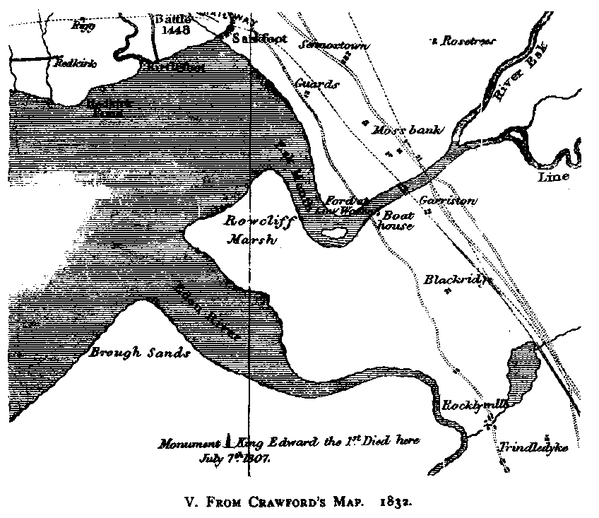 more accentuated later(59),
and the name of "Solway Sands" was attached(60)
to the whole eastern extremity of the firth. The firth proper had as yet no specific
title, and was regarded as part of the Irish Sea. Thus in 1300, in the Roll of
Caerlaverock, that famous castle is described as looking westward(61) upon "la mer de lrlande." Hector
Boece, Buchanan, and Lesley also, in their histories(62),
all refer to Annandale and Nithsdale as bounded by the Irish Sea. The letterpress of
Mercator's Geographia(63) says that the
Nith and Anand both flow into the Hibernian Sea, although the map (Tabula I. of Scotia)
marks "Sulway fl." The corresponding map by Ortelius marks the "Solwey
fyrth." Drayton's Polyolbion (Song 30) makes the Eden end at Bowness:
"At Boulness where myself I on the ocean spend" - the "ocean," which
two lines before he styles the Irish Sea. The Solway he appears not to dignify by its own
name(64). In sixteenth century writings the term,
whilst in some cases vague(65), is in others
distinctly enough extended to apply westward as far as the Nith, but it persistently
retained its characterization as a river. Pitscottie(66)
calls it "the river of Solue." In the middle of the seventeenth century, in
Blaue's magnificent atlas(67) the descriptive
matter - prepared, so far as regards Scotland, by the leading scholars and geographers of
the time - refers to the various rivers of Galloway, and also the Annan Water, as flowing
into the Irish Sea. It might thus seem that in five hundred years the name Solway(68) had scarce been able to establish itself west of
the mouth of the Annan, but since the seventeenth century its progress has been much more
rapid. Under various influences it travelled west and south until, in 1868, the wisdom of
Parliament(69) fixed "the limit dividing the
Solway Firth from the sea to be a straight line drawn from the Mull of Galloway to
Hodbarrow point, in the parish of Millom, in the county of Cumberland," a line which
narrowly escapes catching the north point of the Isle of Man. The scope of the present
contribution to the annals of the estuary does not extend beyond the limits of the general
map which faces the opening chapter.
more accentuated later(59),
and the name of "Solway Sands" was attached(60)
to the whole eastern extremity of the firth. The firth proper had as yet no specific
title, and was regarded as part of the Irish Sea. Thus in 1300, in the Roll of
Caerlaverock, that famous castle is described as looking westward(61) upon "la mer de lrlande." Hector
Boece, Buchanan, and Lesley also, in their histories(62),
all refer to Annandale and Nithsdale as bounded by the Irish Sea. The letterpress of
Mercator's Geographia(63) says that the
Nith and Anand both flow into the Hibernian Sea, although the map (Tabula I. of Scotia)
marks "Sulway fl." The corresponding map by Ortelius marks the "Solwey
fyrth." Drayton's Polyolbion (Song 30) makes the Eden end at Bowness:
"At Boulness where myself I on the ocean spend" - the "ocean," which
two lines before he styles the Irish Sea. The Solway he appears not to dignify by its own
name(64). In sixteenth century writings the term,
whilst in some cases vague(65), is in others
distinctly enough extended to apply westward as far as the Nith, but it persistently
retained its characterization as a river. Pitscottie(66)
calls it "the river of Solue." In the middle of the seventeenth century, in
Blaue's magnificent atlas(67) the descriptive
matter - prepared, so far as regards Scotland, by the leading scholars and geographers of
the time - refers to the various rivers of Galloway, and also the Annan Water, as flowing
into the Irish Sea. It might thus seem that in five hundred years the name Solway(68) had scarce been able to establish itself west of
the mouth of the Annan, but since the seventeenth century its progress has been much more
rapid. Under various influences it travelled west and south until, in 1868, the wisdom of
Parliament(69) fixed "the limit dividing the
Solway Firth from the sea to be a straight line drawn from the Mull of Galloway to
Hodbarrow point, in the parish of Millom, in the county of Cumberland," a line which
narrowly escapes catching the north point of the Isle of Man. The scope of the present
contribution to the annals of the estuary does not extend beyond the limits of the general
map which faces the opening chapter.
III. LEGEND, INCIDENT, AND LAW:
A.D. 634 TO 1292.
10. SAINT'S VOYAGES, A.D. 661 AND 684.
St. Cuthbert made, according to Beda [Bede](70), a voyage to the land of the Niduarian Picts, or Picts of Nithsdale. A tempest arose which prevented the return of himself and friends. They were in danger of perishing of cold and hunger, and only after earnest prayer was the divine goodness manifested by the providential appearance of three pieces of dolphin's flesh - "thre peces of porpas," as a translator has it. The saint had foretold that the storm would endure for three days; the fourth brought a tranquil sea and a favouring breeze. In spite of the mention of Nithsdale, one cannot see any convincing local allusion to the Solway in this rather formless story, which has in it nothing so startling as that of a cruise he had, according to another biographer(71), in the vicinity of the Mull of Galloway (the "Rintsnoc," perhaps Rinns-snook) in a stone boat. The adventures of St. Adamnan in the firth are happily not disfigured by any marvel so gross. The antique narrative of them is, for vigour and inherent truthfulness, unsurpassed by anything similar in the literature of the Middle Ages. What may be ranked as the first historical episode of the Solway makes a strange and picturesque tale, in which the estuary appears under an Irish name, and in which the event adumbrates the growing influence of the orthodox Englishman and the waning of the Celt. In the year 684 Ecgfrid, King of Northumbria, sent an army into Ireland under the command of Beort, his ealdorman. "Miserably they plundered and burnt the churches of God," says the English Chronicle(72), and many prisoners were carried off to Northumbria. When, in 685, King Ecgfrid was slain in battle with the Picts, he was succeeded by Aldfrid, his brother, who had been a pupil of Adamnan, abbot of Iona. The Irish, anxious to have their kinsmen set free, asked Adamnan to go to King Aldfrid and endeavour to procure their release. Adamnan undertook the mission. On his way to Northumbria in 686, he sailed up the Solway. He himself refers to this journey when he mentions(73) that "he went to visit his friend King Aldfrid in Saxonland," and piously adds that "the Lord mercifully saved him from danger." This bald though devout allusion does not compare in interest with the account given by Adamnan's biographer, to whom the Solway seems to have been known as Tracht Romra, and whose vivid description of a strange voyage, written in the Irish language more than a thousand years ago, still survives asa proof that the picturesque is no modern invention. Here(74) it is:
"The men of Erin besought of Adamnan to go in quest of the captives in Saxonland. Adamnan went to demand the prisoners, and put in at Tracht Romra(75). The strand is long and the flood rapid, so rapid that if the best steed in Saxonland, ridden by the best horseman, were to start from the edge of the tide when the tide begins to flow, he could only bring his rider ashore by swimming, so extensive is the strand and so impetuous the tide. Now the Saxons were unwilling to permit Adamnan to land upon the shore. 'Push your curraghs on the shore,' cried Adamnan to his people, 'for both their land and sea are obedient to God, and nothing can be done but by God's permission.' The clerics did as they were told. Adamnan drew a circle with his crozier round the curraghs, and God rendered the strand firm under their curraghs, and formed a high wall of the sea round about them, so that the place where they were was an island, and the sea went to her limits past it, and did them no harm. When the Saxons had observed this very great miracle, they trembled for fear of Adamnan, and gave him his full demand."
This fine story, so true to nature in its account of the onrush of the tide, makes it cruel to suggest a prosaic sandbank instead of the isle that rose from the depths at the bidding of the Saint. We can account for Adamnan's success in his mission without ascribing it to any such miracle. He was, Beda tells us, both good and wise; King Aldfrid was his friend(76); and, last but not least, Adamnan at this very time opportunely acceded to the English and Catholic doctrine in the great observance of Easter controversy(77). The issue is briefly told in the Irish annals(78): "Adamnan conducted sixty captives to Ireland." But his visit was the beginning of the end of a Celtic church independent of Rome.
11. NORSE MEMORIES: A.D. 875.
Ethnological aspects of the Solway suggest many large and interesting problems. The Pict of Galloway, the Scot of Scotland and of Ireland, the Briton of Strathclyde or Cumbria, and the Angle and the Norseman are all present with varying prominence in the changing picture presented by successive centuries after the retiral of the Romans. The impress of each on the nomenclature of the districts is striking and instructive. The annals, so far, have been mainly of Romans, Selgovae, Picts, and Scots. The next chapters will tell of the "Saxons of Saxonland," whom the biographer of St. Mungo(79) preferred to designate as the Angles. It will illustrate the growing power of the English race in the wide territory known as Northumbria, including southern Scotland.
The stirring Norse epoch, the invasion of Cumberland by the Danes, makes no direct memorial addition to the annals of the Solway proper. We know that the Danes, under Halfdan in 875, making their headquarters on the Tyne, harried the Picts and Strathclyde Welsh or Cumbrians(80), destroying Carlisle.(81) The consternation they caused is vividly presented in monastic chronicle.(82) One of the episodes of the well-founded panic caused by "the sword of the Dane" was the attempt to convey St. Cuthbert's body and other relics to Ireland. Ship was taken at the mouth of the Derwent, in Cumberland, but "the wrathful billows rose," and the ship heeled over. A precious manuscript of the Gospels, the penmanship of Bishop Eadfrid, adorned with gold and gems by the anchorite Bilfrid, went overboard. St. Cuthbert evidently objected to go to Ireland, so the ship's head was turned for the shore, and the saint's body was landed at the spot whence it had set sail. Not long afterwards, at Whithorn on the opposite side of the firth, the tide ebbed remarkably, and three miles out from the shore Hunred, one of the band of devotees who had made the ill-starred attempt to carry the saint across the channel, found to his great joy the lost volume. Despite its immersion it had lost neither its outward glory nor the inward beauty of its leaves. This famous Lindisfarne Gospel thus wondrously recovered was cherished with enhanced emotion and pride as one of the chief treasures of the church of Durham, as indeed it is now of the British Museum - a noble monument of Angle-Saxon piety. It has often occurred to me as at least possible that to some such migration and mischance of the sea as this, when the Danish terror lay upon the land, may be due the presence at Ruthwell(83) (anciently Ryvell) of the superb cross there. Tradition persistently remembered(84) that it had been drawn by oxen from Priestside (formerly Priestwoodside) on the Solway shore.
The Northmen's fury was soon spent. They came as marauders, but quickly turned colonists. The very year after their descent on Northumbria they are said to have divided the lands they had won there. Ere long Cumberland, even more than Northumberland, was known as a special home of the Northmen.(85) No legend has kept alive the memory of this large colonization, but on the farm of Graitney Mains there stood, until demolished by the plough in the present century, an oblong earthen mound, terminating in a point at both ends, shaped like the hull of a ship with its bottom upwards, possibly a ship barrow raised over some viking's grave.(86) Place-names on both sides of the firth, and in the firth itself, are a much surer record of the Norse land-taking. A few of the old descriptive geographical names of the Solway and its sands, particularly those of Norse affinity, merit a glance.
Firth,(87) not known to me as occurring before the sixteenth century in connection with our estuary, is, of course, Norse. Wath, though quite possibly of Anglo-Saxon origin is yet of Northumbrian type, suggestive of Norse influence.(88) A low-lying rock cluster, which rises and no more than rises above the level of the sands, is always called a scar - more anciently sker. The word occurs not fewer than fifteen times, and is indubitably Norse. The commonest term for a headland is ness or nese, also certainly Norse. Celtic pol or pow, and Norse bek are common names for streams falling into the firth. Dale, in Nithsdale, Annandale, and Eskdale, is Norse. Annandale had as its older form Annanderdale, which came in room of the still older Celtic Strat Anant, or Strath of Annan. This Annanderdale is peculiarly noticeable as an instance of the Norse genitive in er, more correctly ar: the river Annand, like the Nid in Yorkshire, took a genitive in er, and the Annand's dale, after some uncertainty between Annandesdale and Annanderdale, became decisively Annanderdale, just as the Nid's valley became Nidderdale.
Grune,(89) the point north of Silloth, is an ancient geographical term,(90) denoting a snout. In the fishings of the Solway one or two other terms of unusual suggestiveness have been preserved. It was a curious and unjust remark of a friar of Carlisle(91) who might have spoken otherwise had he remembered the fates of his own city - that the Norsemen "had more skill in fishing than in fighting." Their fighting has left its record; so perhaps has their fishing, in terms and things either still in use or not yet forgotten. Raise nets, in earlier form rais-nets, were floated with the current, and may have been so styled from Norse rás, a channel. Haav nets [now usually haaf nets; they're still in use today], used by wading out into the tide, may well be from the Norse also, as haf is Old Norse for sea, and as such was not unfamiliar in Scottish geography(92) and records.(93) It is evident from these instances(94) that the Norse in Solway names is an appreciable quantity.
Yet another name is remarkable. On the old map(95) of 1552, the strand of the mouth of the Esk, at its junction with the sands, is labelled "lange rack." The sandbanks between Silloth and Salterness were known(96) about 1563 as the " Longrake Sande." Hence, it is highly probable that, in and before the sixteenth century, the term Lange Rack applied at the east end, synonymous with Long Rake at the west, must have designated the channel between these two extremities - the sea-river, near twenty miles long, formed by the united outflow of the waters of the Solway basin. When the tide is out this stream is seen threading its way through the sands, and widening as it nears the permanent sea water, in which it merges at last. Viewed from the top of Criffell, at low ebb, it makes an impressive part in the great picture outstretched eastward beneath - the ever narrowing current veining with its dark sinuous line the far-reaching expanse of 20,000 acres of yellow-brown sand. A rack, the geographers tell us,(97) is the Northmen's name for a crooked narrow channel difficult of navigation. The classical example is the Skager Rack of Denmark, where, to the east of the Skaw,(98) the sea way for ships is a strait and winding passage marked for miles by a series of buoys between the sandbanks. So early as the fourteenth century a fishery at Aberdeen was called(99) the Rak or Raik. It lay in the tortuous tidal and sandy mouth(100) of the Dee. The meaning of the Lang Rack of the Solway is thus far from obscure.
There are no islands at all in the area of the Solway Firth dealt with here, and only two or three very small ones in it altogether. One of them, now called Heston, lies just outside of the Rough Firth - a noticeable name - at the mouth of the Urr. Heston is believed to be the island on which Sir Dougal MacDowall had his "peel" in the middle of the fourteenth century, when it was known as Estholme.(101) "Holm" is a wellknown Norse word for island.
The southmost point of Galloway, and the westmost on the northern shore of the firth is the Mull. Barbour, quoted by Wyntoun, calls it(102) the Mullyr-snwk. Snook is a geographical term believed to be of Northern origin,(103) a metaphorical "snout."(104) The grammar of the combination, with its genitive in r, is, however, still more decisive. It was by exact parity of nomenclature that the Norsemen called(105) the Calf of Mull (Myl) the Mylar-Kálf. The Norsemen's impress on the Solway's historical geography is thus very plain: it begins at the headland round which their galleys came, and it reaches the extreme navigable point, the ford of Sulwath.
12. TRADITIONS OF THE SCOTISWATH, A.D. 937.
Fergus, the son of Erc, the first of the genuine historical kings of Scotland, is credited by Fordun with subduing the lands on both sides of the Scotiswath (vadum Scoticum) from Stanemore (mora lapidea) and the Hebrides to the Orkneys.(106) It was a far cry from Fordun's day back to that of Fergus Mac Erc, who died, by some accounts, in 501; but the passage, however inexact as history, has a particular geographical value. Fordun supplies his own explanations, as has been seen already. The Scotiswath(107) was the Sulwath, and the south-eastern limit of the diocese of St. Mungo (who died about the year 603) was the Rere Cross on Stanemore,(108) a summit still part of the boundary of Westmorland and Yorkshire, as of old it was of Cumbria and Northumbria. We shall meet again the collocation of the Rere Cross and the Solway, but meantime a curious legend demands attention.
According to the sober English chronicle, King Athelstan in the year 934 fared into Scotland with a land force as well as a ship force, and harried it much. Three years later he fought his renowned battle of Brunanburh, Brunesburh, Brunnanwerch, or Bruneswerce, the site of which remains unsettled.(109) Out of the expedition of 934, or the victory of 937 - more probably the latter - there had by the thirteenth century grown up a picturesque legend to the great glory of St. John of Beverley,(110) on whose altar Athelstan had laid his dagger,(111) as a pledge of his material gratitude if the saint could secure him victory. Under the banner of St. John he proceeded north. The Scots hearing of his advance, retired across the river, which is called the Scots' Wath,(112) so that within their own bounds they might the more securely prepare themselves to resist. When the king came to the river and learned that the Scots had crossed, he ordered his men to pitch their tents upon the bank. During the night there appeared a personage in priestly robes, who said, "King Athelstan, prepare thy men on the morrow to cross that river for battle with the Scots." It was St. John of Beverley; and the vision closed with a promise that the English king would be victorious. Next morning Athelstan's army, eager for battle, crossed the river, and found the Scots arrayed on the other side, A great battle ensued, in which, of course - whether it was the memorable fight of Brunanburh(113) or one of less note - St. John's presage of victory was gloriously fulfilled.
Such tales have always a strong family likeness, and there is nothing very distinctive about this one. It is more notable because of its reference to Scotiswath - a river which was called the Scots' Wath or ford - than because Solway legends are scarce.
Of these there is another which, however
extraordinary, has nothing miraculous. After what has been shown with regard to what the
Solway was, it is not incougruous that its earliest recorded, albeit dateless, maritime
engagement should be alleged to have been a battle of horse ! For this Camden(114) is sponsor. He tells us of Burgh by Sands that
"the inhabitants say that under this burgh, in the very aestuary, there was a sea
fight between the Scotch and English, and that when the tide was out it was managed by the
horse."
13. THE SOLWAY AS A BOUNDARY: A.D. 1092-1157.
Whilst in a broad sense the western waters of the estuary always formed the boundary between Cumbria, the great Cumberland, on the one hand, and Galloway, the province of the "stranger Gaels," on the other, this, strictly, was not always admittedly the case. Though each enjoyed at times a precarious independence, the forces for unity were at work in spite of tribal protest. In the seventh century both Cumbria and Galloway were subject to the English kings, and in the tenth and eleventh to the kings of Scotland. In 945 Cumbria had been granted by Edmund of England to Malcolm, King of Scots. In 1069, it was claimed,(115) Cumbria included Galloway. William the Conqueror, invading Scotland in 1072, entered "æt tham Gewæde," according to one MS. of the English Chronicle. He fared in "ofer the Wæth," according to another. The annals of Waverley, long after, term(116) the place "Scotwade." Much learned ink(117) has been shed to prove what place was meant, in support of the rival claims of the Tweed, the Scotewater or Forth, and the Scotiswath or Solway. King William advanced with a "land force" and a "ship force," and after crossing "the ford," so ill defined in the English Chronicle, he reached, according to other authorities, a place(118) called Abernithi, which some historical speculators(119) have sought to find, not on the Tay in the modem Abernethy, but in the confluence of the Nith with the Solway. Some annalists, considerably more recent and suspected, represent the Conqueror as returning through Cumberland and fortifying Carlisle, but it must be owned that this evidence, which otherwise might have lent some colour to the Nith-mouth inference, is quite late and unreliable.(120) The local historian must needs relinquish with a sigh any hope of absolute proof that William the Conqueror ever crossed the sludgy ford of Solway.
Cumberland, it is well known, formed no part of the Conquerer's England, and was wholly omitted in the great survey of Doomsday. Yet tradition soon forgets, and at an early date it was told how William the Bastard bestowed(121) all the lands of the county on Ranulf le Meschyn [Ranulph de Meschines]: "all the land," as a thirteenth century statement(122) of the claim defined it, "from the place called Rere Crosse upon Staynmor as far as the river towards Scotland called Sulewaht to the true marches there between England and Scotland." This was probably no truer than Boece's circumstantial account of the erection of the "Re-crois " by the Conqueror as the southern limit of his grant of Cumbria to Malcolm III, with statues of the two kings adorning the pedestal.(123)
It was not until 1092, when William Rufus seized, restored, and occupied Carlisle, building a fort or castellum there,(124) that the Solway took that place as the march between England and Scotland, which it maintained throughout the reign of Henry I. Henry strengthened the English hold on Carlisle and the shire by walling the city.(125) On his death in 1135, David I of Scotland took advantage of the civil war to wrest Carlisle, partly by war, partly by diplomacy, out of the hands of Stephen, and to reassert successfully the Scottish claim to Cumbria. David made Carlisle his capital or residence, and some time after the peace of 1139 he heightened the city walls, and built the great keep there.(126)
"The Kyng Dawy wan till his crown,
All fra the Wattyr off Tese off brede,
North on till the Wattyr off Twede,
And fra the Wattyr of Esk the est
Till off Stanemore the Rere-Cors west." (127)
Whilst he lived the Solway was thus no boundary of the realm, but after his death at Carlisle, in 1153, his grandson, Malcolm IV, retained Southern Cumbria only four years. In 1157 this Malcolm the Maiden ceded(128) to Henry II "the city of Carlisle," and thenceforth Cumberland, long an appanage of the Scottish crown, passed definitively into English territory. Thenceforth, too, the Solway became a vital part of the marches of the realms, giving a sanction of history to the tradition that the feudal service of the lieges of Westmorland and Cumberland was restricted, as they themselves declared(129) to Edward II, to meeting the kings of England on their progress towards Scotland at the Rere Cross, to going in the vanguard to "la Marche de Solewathe," and on the return to taking the rearguard from Solway to the Rere Cross again. Apparently this duty of escort to and from the normal place of passage into Scotland lay on the tenants by cornage,(130) who, by a tradition resulting from a mistaken etymology,(131) were also accredited with the function of the blowing of horns,(132) somewhat fantastically referred for its origin to a supposed old custom associated with the defence of the Roman Wall. More than a century after the cession of Cumberland to the English, the Bishop of Glasgow claimed(133) that his diocese still extended, as it had once done, as far as the Rere Crose.
14. A PRETENDED BALLAD OF THE CRUSADES: A.D.
1189.
We have seen a saint sailing up the Solway in the seventh century. If we might accept a certain ballad,(134) we should see a group of crusaders setting sail to join the host of Richard I, under the leadership of Sir Eustace do Maxwell.
Schir Eustrece Maccuswall he's cau'd,
In sothe Skottlonde he bode;
On his bred banner stode bedight
The egil and the rode."(135)
Describing this commander as "Thane of Stra-Nid sae green," and telling of his Dumfriesshire companions-in-arms, including the "Thane of hie Sanquhar's peel," the balladist tells of the departure from the Solway to join the English king in his capital.
"In twa score Carvels frae Cockpool
Wee brilzean Lundin raucht,
A myghtye meany and valziant thrang,
Wha fremit ferly's saucht."
So they set out for Scanderoon "owre the sea sae braid."
It is unfortunate for the ballad's pretensions as an antique that its rhymes and diction should so palpably betray it, and that it should bristle with neo-archaisms. Historically there was no Eustace de Maxwell of Carlaverock in the days of Richard Coeur de Lion. There never was a thane of Strath Nith or a thane of Sanquhar. Peel was an unknown term in Scotland until Edward I introduced it, and Sanquhar peel is probably an example of it very late in origin. It must be said, however, that there is some faint traditional evidence(136) for one representative of the Maxwell family having gone to Jerusalem as a crusader in the thirteenth century, under the banner of King Louis IX. The carvels from Cockpool, nevertheless, are most probably the creation of a poetic imagination, stirred by the renaissance of the ballad, late in the eighteenth century. The poem apparently had its origin at Friars' Carse. Some critics have suspected that Burns had a hand in assisting Captain Robert Riddell to compose it, but such a suspicion seems an injustice to the Bard.
15. THE AVENGING EDEN: A.D. 1216.
Many a strange tale is told of unwary passengers overtaken by the tide while in the act of crossing the Solway. The geographical thesis of the preceding section, and the maps, explain that under some conditions there would be a considerable expanse of sand to be crossed at the original ford. They suggest also several circumstances adding to the danger of surprise. The long time necessarily occupied in crossing, and the liability to mistake the safest track and fall in with a quicksand, must often have made the risks of the passage very serious. A half hour's miscalculation of the tide might well cost many a passenger's life. The earliest narrative of this sort belongs to the year 1216. King John had invaded Scotland, with a ferocity carried by himself personally to an unkingly extreme. ln return, King Alexander II made a destructive inroad across the border, and ravaged Cumberland.(137) The Melrose Chronicle states that he granted his peace to religious persons, and that it was against his instructions that a band of his followers pillaged the Abbey of Holme Cultram, in which, as a daughter-house to Melrose, the chronicler naturally took a close interest. Laden with their spoil the Scots, returning, required to cross the Eden. That "dainty Cumbrian queen," as Drayton calls it, when it reaches Rockcliffe, is nearing the close of its journey from the shoulder of a Yorkshire mountain at the head of the Mallerstang. At Rockcliffe its broad and limpid waters ripple over a pebbly channel, washing the base of a high red cliff. A little further down its waters take somewhat of the tawny complexion of the Solway sands, through which they are beginning to flow. The neighbouring sandy foreshore is coated with rough merse grass, on which numerous herds of cattle graze. As one walks along the marsh skirting the river, a quiet, sibilant, but penetrating sound from the sea is the announcement of a wave racing up the Eden. A line of advancing foam breaks gently on each side of the sandy channel. In a few minutes, where before was a narrow current of fresh water with a wide margin of sand, there is a broad volume of brine, and the estuary of the Eden is flowing "from bank to brae." In the winter season the scene, impressive under any conditions, is much intensified, especially if the tide is high and there is a southerly gale behind. Then the sea approaches with great speed, gaining as it goes; the wave is white with tumbling foam; a great curve of broken surf follows in its wake; and the white horses of the Solway ride in to the end of their long gallop from the Irish Sea with a deep and angry roar.
In February, 1216, some terror-stricken survivor may have witnessed this tumultuous onrush of waters, whilst his companions-in-arms, heedless of danger, were fording the Eden. Suddenly the tide was upon them - escape was impossible - and 1900 men were swept away.(138) What wonder if a monk saw in that pitiful scene of death the arm of God, which only slumbered till "that plundering crew"(139) of Scots was in mid channel,
"Then bade the deep in wild commotion
flow,
And heaved an ocean on their march below."(140)
16. THE FLEET OF ALEXANDER III: A.D. 1264.
Alan of Galloway was in a sense the pioneer of the Scottish claims to the Isle of Man. His expedition in 1228, when he left his bailies behind him to collect tribute, has all the appearance of an affair of conquest, in which he and his colleague, the Earl of Athole, were fighting for their own hand.(141) The Norse kingship, long divided against itself though it was, had strength enough to survive until the battle of Largs, in 1263. It is significant of the great uprising of national spirit in Scotland, due to that defeat of the northern power, that it should have been so directly followed by energetic action for the annexation of the Isle of Man, and for the effectual incorporation of the western isles. King Haco, brooding over his ill fortune, had, with the remnant of his navy, reached Orkney only to die. No sooner was it known that he was dead than Alexander III prepared to invade the Isle of Man, whose uneasy sceptre was held by Magnus, the son of Olaf. All was in readiness; early in 1264 the fleet was moored to carry the army across the channel to the little isle.(142) Where the ships lay is not on record, but as the king's journey was by way of Dumfries, it is no idle speculation that the Solway Firth, near the mouth of the Nith, way have seen the gathering of Alexander's vessels. But Magnus Olafsen did not show fight: he sent his nuncios to declare his willingness to come to terms. His letter that he would hold(143) his land of Man in vassalage is one of the lost muniments of Scotland. And promise was not enough. Alexander persisted in his expedition in spite of promises, and the Kinglet of Man hasted in person to Dumfries, where he became Alexander's man, doing homage for his kingdom, and undertaking feudal service with ten "pirate galleys" - pirate(144) was once a word of innocent associations - five of them with four and twenty oars, and five of them with twelve. Followed up as this was by proceedings against the refractory Hebridean islanders,(145) it was a well-omened effort for the consolidation of the Scottish realm. The King of Man's feudal holding as a Scottish vassal was not destined to endure. Magnus died in the end of 1265, and next year the suzerainty of Scotland was converted, as far as treaty with Norway could convert it, into actual sovereignty(146) of Man and the Sudereys, and all the other isles on the west and southern sides of the "Great Haff." The tenure of Man by galley service may well have been the basis of a marine policy, the continued maintenance of which is attested by more than one of Robert the Bruce's west coast charters, having reddenda of ship service,(147) sometimes with twenty-six or even forty oars.
17. MARCH LAW: A.D. 1249-1292.
The earliest contemporary mention of the Solway under that name belongs to the year 1218. The turbulent Reginald, King of the Isles - of whose doings the chronicle of Man is so full - had safe conduct to present himself before Henry III, and do homage. Henry issued commands(148) that the Norse kinglet was to be met by an escort, either at "Sulewad," Carlisle, or Lancaster. Whether Reginald was expected by sea or land is uncertain, but there can be no uncertainty or indefiniteness about the place of meeting first on the list. How well defined a place it was is manifest from the border laws.
The border sheriffs and jurors who, in 1249, declared the laws of the marches(149) between Scotland and England, deliver it as established that "the counties of Carlisle and Dumfries ought to answer at Sulewath, according to the laws and customs heretofore in use there between the two realms."(150) It would be superfluous to enter at any length upon the code of march law then in force, with its references to "Handwarcelle," or wager of battle, as the normal ordinance. Still less is it necessary to go into detail to show that this border code remained living and effective, as seen from documentary confirmations,(151) in 1280 and 1292. But one clause in the statute is peculiarly germane to the geographical questions already discussed. If a borderer in the one country was found in possession of a horse, ox, cow, or pig claimed by a subject of the other country, and if after wager of battle had been ordained the possessor decided at the eleventh hour to admit the other party's claim, he had to give notice of the fact, and at the appointed time to drive the beast into the Esk.(152) If it passed the midstream in safety, the wrongous holder was quit of the claim, but if it sank before it could reach the midstream, he was answerable for its value. A special interest attaches to this curious provision, since it illustrates two facts: (1) That the midstream of the Esk was the division line of the kingdoms, and (2) that the crossing of the Esk was at Sulewath.
It can be proved from purely English documents that, in the thirteenth century, the territory between the Esk and the Sark, subsequently known as the Debatable Land, was not debatable at all. It was admittedly Scottish soil. Conclusive evidence is found in the facts relative to the Barony of Kirkandrews on Esk,(153) now represented by the English parish of that name, which includes Solway Moss and the whole land south of it between the Esk and the Sark. This barony was never claimed as English before the fifteenth century.
In a writing of date 1282 relative to Arthuret in England across the Esk from the area now known as Solway Moss, there is very distinct proof that that area was Scottish. The name Solway Moss is not original. The battle of 1542, which has made it historic, was generally styled by contemporaries not Solway but Sollome or Solane Moss.(154) The extinct hamlet from which it had its name was Salom; in 1280 a jury of Cumberland made express mention(155) of "Salom in Scotland." In fact the boundary in the thirteenth, and much - if not all - of the fourteenth century, was the Esk. It was not until 1552 that it was finally shifted to the Sark.
IV. SALTWORKS AND FISHERIES.
18. SALTMAKING.
In its saltworks the Solway possessed an industry of great importance and high antiquity. At intervals all along both its Scottish and English shores there were salinae or saltworks. These were all situated at places where a loose and porous clayey sand, called "sleech," formed natural salt beds, presenting a surface capable of retaining a very heavy solution of salt after being covered by the tide. The heat of the summer sun disclosed the salty particles glittering on the sleech like hoar frost. From time to time in due season the salters,(156) as the makers of salt were called, first collected the surface sleech on the salt bed by a kind of sledge-drag or scraper, called a "hap," drawn by a horse, carted it to the merse or grassy beach, and laid it in heaps beside the place where, after some time, it was to be filtered. Neither the apparatus nor process of filtration was complex. A hole dug in the merse formed a "kinch" or pit: its bottom and sides were puddled with clay to make it watertight: on the bottom, above the clay, peats were laid: the peats in turn were covered with a layer of sods: sleech was put on the sods till the kinch was nearly filled to the brim, and finally, as much salt water was added as the kinch would hold. Filtering through the sleech and the sods, the brine at length, when strong enough to float an egg, was allowed to escape by a tube or spout into a wooden reservoir, out of which it was lifted and carried in pails to the salt-pans.(157) These were broad, shallow metal pans, beneath which great fires of peat were lit. After about six hours' boiling the process was complete; the liquid of the brine was wholly evaporated, and the pans full of the finished article. The name of Saltcotes(158) was given to the little cluster of buildings which contained the pans, the "girnels," or stores in which the salt was kept, and the dwellings of the salters. Such was the system pursued on the Solway in the end of last [18th] century, and there is small reason to doubt that substantially the name primitive and laborious(159) mode of manufacture prevailed from early times. It was then a most important industry, salt forming, no doubt, a staple article of commerce, for the supply of which the long sandy stretches ofthe Solway offered conditions so favourable as to create a practical monopoly there.
"Upon the banks of Sulway in June and July," says John Monipennie,(160) writing in 1612, "the country people gather up the sand within the flood marke, bringing it to land, and laying it in great heapes; thereafter they make the salt spring water, and cast it upon the sand (with a certaine device), causing the water to run through the sand into a hollow pit purposely made to receive the water, which water being boyled in a little vessel of lead, there is made thereof good whyte salt after the temperance of the weather. This place is called the Salt Coates."(161)
19. SALTWORKS.
The value of saltworks at a remote period is well seen in the care with which a formal title to them is entered in the early cartularies. Important evidence concerning the Solway salt workings has thus been preserved. In the Book of Melrose(162) there is entered a charter executed by Richard Fleming, chamberlain of William de Brus, Lord of Annandale, in favour of the monks of Melrose. A witness to it was Roland of Galloway, so that the latest possible date is 1210. It conveyed a saltwork on the side of the great way (magna via) at the church of Rainpatrick. The ground included was bounded on the east by a great ditch, on the south by the sea, and on the west by another saltwork already conveyed to the monks by William de Brus. Pertinents of the grant were pasturage for four oxen and a horse, and a right of fuel. The property was subject to the annual burden of a pound of pepper.(163) The other saltwork at this point was held of William de Brus for payment of a mark of silver, which, however, he never exacted, and which his son subsequently discharged altogether.(164)
Rainpatrick, once an independent parish, is now merged in the parish of Graitney. The church sat close to the sea, but even the spot it once hallowed has been washed away. Its prominent situation as a headland, a mile west of the Lochmabenstane, made it so much of a typical border site, that the Red Kirk has in a sense passed into history.(165) Its whereabouts is still indicated by the name of Redkirk Point, applied to what remains of the headland. In 1294 the monks of Melrose made a bargain with the monks of Holme Cultram, under which the latter acquired from the former their saltworks at Rainpatrick, subject to an annual payment of half a mark of silver.(166)
The Cistercians of Melrose and of Holme Cultram appear to have approved of the salters' motto, Sal sapit omnia, and almost divided the saltworks on the Solway between themselves and the Benedictines of Wetheral. These last held more than one saltwork on the shore off Burgh by Sands, granted and confirmed by successive charters of the De Morvilles, lords of that place, and their connections.(167) Roland, Lord of Galloway, just mentioned, son of that Uchtred, whose brutal murder by his brother forms so revolting a chapter in Galwegian annals, gave saltworks to both houses. That granted to Melrose(168) was at Preston, in Kirkbean parish, and included pasturage of six cows, six oxen, and one horse, also a toft and croft [land for building a house on, with attached arable land] to make a residence, and right of fuel in the adjoining woods adequate for the supply of the pan (patella) of the saltwork. Roland gave also, but for a rent of £10 a year, to the house of Holme Cultram, a saltwork(169) at Lochendello,(170) with rights of wood for the operations, and of pasture for four cattle and 500 pigs. To them, too, he made a grant of another saltwork,(171) where the descending slope of Criffell protracts itself into a flat promontory. It was called the saltwork of Salternes, a name attesting that before the monks got their charter the promontory had its saltwork. The word denoting simply the salters' point, naturally and regularly got worn down to Satterness;(172) but Salterness continued to be the recognized name(173) even at the end of the eighteenth century. It was reserved for some overwise person or persons within the last hundred years, giving way, perhaps, to baseless anterior philological fancies,(174) to improve it into Southerness; and authorities on place-names, who ought to have known better, are accessories after the fact.
Yet Satterness still lives vigorously in local pronunciation, especially amongst the older inhabitants of the districts within which it is a household word. It is an invincible witness for the self-explanatory,(175) historical Salterness against the unwarranted upstart at present enthroned in our maps and topographies. Southerness, with its meaningless meaning of southern point(176) - for it is not the southern point even of its own county - threatens to descend to remote posterity in the face of antiquarian protest, and in the very teeth of the parallels of latitude. Is it too late for geegraphers to entertain an appeal?
20. A TRADITION OF THE SALTERS.
A thousand traditions, often futile enough in other respects, illustrate the national patriotic fervour of reverence for the memory of King Robert the Bruce. One of these(177) concerns the salters of Annandale. On the farm of Broom, in the parish of Cummertrees, there was a field once known(178) as Bruce's acres. There the king is said to have suffered a defeat at the hands of the English. Skirting the shore of the Solway in his retreat, he came to a house where the inhabitants gave him rye bread, whereupon, with that readiness to baptize places which characterizes monarchs in tradition, he named the place Ryehill, and sure enough Ryehill is still the name it bears. Resuming his journey he next reached Priestside, where a farmer's wife gave him a second repast, this time of bread and eggs. Strange to say, however, there was no salt, for, as the good-wife explained, the people in these parts were not allowed to make it. Bruce thereupon, saith the story, "with his usual generosity, immediately granted to the people in that quarter a charter to make salt, duty free."
Traditions, like eggs, are best taken with an occasional pinch of salt. Ryehill, unfortunately for this one, bore that name(179) before the Bruce was born, and there was no salt duty in Scotland until nearly a century(180) after the Bruce was dead.
21. A SKETCH OF THE HISTORY OF THE
SALTWORKS.
Reminiscences of these saltworks occur in the placenames of the seaboard parishes. Salterness was not a solitary instance. There is a Salcots on the Blackshaw Merse on the shore of Carlaverock parish. The "Saltcottis" of Ruthwell is a name of very frequent occurrence in the sixteenth and seventeenth century title deeds.(181) One of the saltworks in that parish is supposed to have belonged to some religious body. It formed part of the kirk lands, and was called - perhaps from Our Lady of Melrose - Lady Saltcots,(182) whence Ladyhall, the present name of a farm on the shore. On the English side there are early allusions to more than one saltwork,(183) belonging to the Abbey of Holme Cultram, and situated at the mouths of the Wampol and the Waver. To this day one place bears the name of Saltcots, which it bore(184) in the time of Edward I. The word "cot" is, in a good many instances here and elsewhere, found associated with saltworks, so that the place name Rabycotes, not far from the last named Saltcots, is probably a memory of the same sort.
Of the history of these saltworks on the Scottish side, not a great deal is known. In 1329 salt from Dumfriesshire went to the pantry of King Robert the Bruce.(185) In 1656, during the Commonwealth, Cromwell imposed a tax of some kind upon the salters, to their violent indignation. By petition,(186) immediately after the Restoration of Charles II, the salters of Annandale made strong protest against this action of the Protector Cromwell. "Inregaird of the painfulness and singularity(187) of the work," it was said on their behalf, they had "ever been frie of any publict imposition or exaction untill the yeer 1656 or therby, that the late Usurper, contrare all reason, equitie, or former practice, forced from them ane exaction, to ther overthrow and ruine, and therby so depauperat them that they are in a starveing condition." By this time it would seem that the salt manufacture had its headquarters in Ruthwell. In the seventeenth century Solway salt, famed for its whiteness and purity, was known(188) as "Ruthwell salt." The petitioners were successful in their application to Parliament, the obnoxious tax was abolished, and when a salt tax was imposed at a later time, this Parliamentary proceeding kept the Annandale salters exempt. Whatever be the exact story of the Annandale exemption from the salt tax, it is distinctly interesting to observe, as I have learned from old inhabitants of the district, that the exemption did not extend to Nithsdale: it stopped on the eastern bank of the Lochar, the very boundary(189) of the territories of the first Robert of Brus, Lord of Annandale, in the twelfth century.
So long as there was a salt tax the salt industry flourished. In Ruthwell it did not die out until after the first decade of the present [19th] century, when the abolition of the salt tax all over the country, combining no doubt with better and more plentiful supplies from salt mines, placed the Ruthwell salt-making in the trying position of a long protected pursuit exposed to the ordeal of open and equal competition. So ended the saltworks on the Solway, after an activity of full seven hundred years.
Between Brow-Well and Powfoot, along the merse between the arable land and the bare sand of the Solway, near the scattered farmhouses collectively known as Priestside, there may be seen at intervals holes in the grassy foreshore, from two to three feet deep, a dozen or thereby wide, and six or eight across; the bottom is black, and either dry or half filled with dark and stagnant water. They are the "kinches" or pits once used in the salt manufacture, and are almost the sole remaining local proof that the saltworks once were. The sterile influence of the salt still filtered there a century ago, remains yet, and there is no growth or vegetation in these lifeless holes. They are thus no unfit memorials of a dead industry.
22. SOLWAY FISHINGS.
Valuable as were the saltworks on the Solway, the salmon fisheries were more valuable still. The suggestions of the charters are unfortunately meagre on the modes by which the fish were taken. Two methods are specified. First there were the sand fishings. One can scarcely doubt that these would be exercised by fixed nets, although the early records leave us without detail as to specialities. On the English side, the fishings appear to have been held on very much the same principle as rights of pasturage, apportioned according to the extent of the ground held by the various owners of land. Thus a grant(190) to the monks of Holme Cultrum conveyed to them Thomas de Multon's "full fishery in the water of Eden, pertaining to his freehold in the vill of Burgh, that is, two nets to each carucate of land." An earlier concession(191) was that of "one entire net" at Solleburgh in the same vicinity, made by Hugh de Morville, one of the murderers of Archbishop Thomas à Becket. It carried with it a booth and adequate place for drying the nets. Secondly, there was boat fishing. Allusions are made to such in a charter of fishings, with right "to have and hold a fishing boat with pertinents" at the mouth of the Alne.(192) Another grant to the monks of Holme Cultram of fishings at the mouth of the Wampol, mentions(193) both sea and sand fishery (piscariis maritimis et sablonibus). About 1190 Ivo, the founder of the Kirkpatrick family, held a fishery "between the fishery of Blawad and the water of Hesch." Blawad, no doubt one of the wads or waths of the narrow estuary, was near Torduff Point, its more recent name being Blawatwood or Blaatwood. The Hesch of course was the Esk. lvo's rights included a place to stretch his nets on, and the annual rent charge due by him was a pound of pepper, or six pennies.(194) When William de Brus, between 1191 and 1215, gave to the Abbey of Melrose a fishery beside Redkirk Point, he expressly empowered the grantees(195) "to practise whatever kind of fishing they shall choose."(196)
The monks of Holme Cultram, chief owners of the saltworks, were also chief owners of the salmon fishings in the estuary - a pleasant suggestion of the industrial and commercial side of the monastic system. In addition to various fishings held by them in England, they had at least four in Scotland. Two of them were in Galloway, one apparently in the vicinity of Southwick,(197) the other on the Nith (Nud or Nyd) at Kirkconnell(198) [The] Other two were in Annandale - the first at Torduff (anciently Horduf) in Dornock(199) parish, and the second at Rainpatrick,(200) the latter being the one originally granted to the house of Melrose, from which it was transferred in fee-farm to the English abbey.
One feature of fishing grants in Cumberland merits the attention of legal antiquaries. Although gifts to religious houses at times took the form of a stated number of fish - for example, fourteen salmon or six salmon(201) - from the annual catch in inland river fishings; and although, of course, there were tithes of fish; yet there is in some charters a reservation, which seems to be a feudal rent, in the noteworthy form of the "eighth fish" from the basket.(202) This does not occur in the Solway fishing bequests.(203)
The early grants by the lords of Annandale have an interesting reservation. The sturgeon, now distinctively a royal fish, was reserved from the fishings.(204) Another reservation, long specifically royal, was that of the great fish grossus piscis or le graspes. Writers on old English law(205) claim the whale, like the sturgeon, as a royal fish, but with a difference. The king was entitled to the whole sturgeon if he demanded it, but a whale fell to be divided, the head going to the king himself, while the tail was a perquisite of the queen. One reason assigned for this strange apportionment was that it was designed to furnish the queen's wardrobe with whalebone - a very unfortunate reason when it is remembered that the head [where the whalebone is] was the king's share. Old Scots law also provides, though differently, for the case of "a quhail [whale] fundyn on the see cost."(206) It was, according to charter, apparently a royal escheat, of which the kings made liberal grants to the church. David I gave teind [a tenth] of it to Holyrood Abbey. Malcolm IV, confirmed by William the Lion, Alexander II, and Alexander III, gave and granted to the monks of Dunfermline the whole head of every whale stranded or captured, except its tongue. By a dubious fragment of old Scots legislation, the right to the escheat depended on the weight of the fish. If it did not break down a six-ox cart before it was out of high-tide-mark, it might fall to the adjacent landholder; otherwise it was the king's. There were thus eccentricities in Scotland too.
V. WARS OF EDWARD I: 1296 TO
1307.
23. CAMPAIGNS OF 1296, 1297, and 1298.
From the outbreak of the War of Independence until the Union of the Crowns, the Solway played so large a part in Border history that there was some fitness in the circumstance that there the first overt act of warfare took place. On 26th March, 1296, the Scots, forestalling by two days Edward I's invasion of Scotland on the east march, entered England at Solway. A contemporary(207) states that they crossed the "water of Sulewath" at three places, which are not further specified. Their futile attack on Carlisle was sternly revenged at Berwick, which Edward stormed on 30th March, with terrible slaughter of men, women, and children.
King John Balliol's career, brief and inglorious, ended in his abject renunciation to Edward I of the crown which Edward had adjudged him. The Ragman Rolls were sealed by the Scottish barons, and it seemed as if the last day of Scottish independence had passed. But Wallace roused the drooping spirit of the land. Blind Harry,(208) in his poem, makes his hero dream in the little church of Monkton of an interview with St. Andrew, and of seeing
"a felloune fyr,
Quhilk braithly brent on breid throu all the land -
Scotland atour fra Ross to Sulway sand."
During the momentous patriotic struggle of 1297, there are scarcely any allusions to the Solway. In the apocryphal battle of Biggar, Blind Harry makes Edwand I retreat through Annandale, telling that he
"At the Birkhill a litill tary maid,
Syne throuch the land, but rest, our Solway raid."(209)
And, again, he tells (and here his account is probably not quite so far from the actual) how Wallace drove the English before him out of Sanquhar and other Nithsdale strongholds, and how, aided by Corries and Kirkpatricks, Johnstones and Hallidays, he pressed on them till they turned to bay by the sea shore.
"For Maxwell(210)
als out off Carlaverok com;
On to the Sotheroun, the gaynest way is nom;
In to the chass so wysly thai rid;
Few gat away that com apon that sid.
Besyd Cokpull(211) full feyll fechtand they fand,
Sum drownyt was, som slayn upon the sand."
English chronicle does not allow to Scotland all the glories of the time. In 1297, about Christmas time,(212) Sir Robert Clifford, with a large force, crossed the "water of Sulewath," whereupon a trumpet proclaimed to the troops that they were free to pillage on their own behalf - a permission which, the historians rather unnecessarily assure us, gave great satisfaction. This expedition was signalized by the battle of Annan Moor.(213) In the following year, preparatory to the campaign distinguished by the complete overthrow of Wallace in the battle of Falkirk, King Edward possibly designed to invade Scotland on the west, though ultimately he did so on the east. An assembly of Welsh troops, fixed first for the 17th and afterwards for the 25th of June, 1298, was ordered to be made at Carlisle,(214) where also certain stores, chiefly from Ireland, were directed to be delivered by sea and land as quickly as possible.(215) Corresponding precepts were issued for consignments of provisions to Berwick.(216) But most of these writs were not out until April; the army was on the march in June, and the commissariat system broke down. The resulting embarrassment was very clearly reflected in Edward's letters of remonstrance.(217) In the end the trouble became so acute that the sequel of his victory at Falkirk was an enforced retreat.(218) The stores at Carlisle may have had something to do with his returning by the west march, through Annandale. Blind Harry,(219) with substantial truth, tells us :
"In raid battail the King to Sulway
raid,
With mekill payn, fast upon Ingland cost."
Contemporary historians(220) are all agreed that he passed from Lochmaben to Carlisle, and although not one of them names the exact line of his journey, there need be little doubt that Harry is right, and that Edward on that occasion first saw and crossed the ford, which he was destined seldom to see except under circumstances of vexation. To him it proved, from first to last, a symbol of disappointed hopes.
24. PREPARATIONS OF 1299.
A campaign annually in 1296, 1297, and 1298: Scotland as far as ever from being conquered: yet one more expedition necessary in 1299 - such was the situation King Edward had to face. He had gained little by the labours of 1298 in spite of his victory over Wallace. Stirling in 1299 was in extremis; and the sphere of the English dominance was closely restricted to the vicinity of the fortresses manned. Dumfries and Lochmaben were amongst the minor castles thus held. The latter, a place of no great strength, had in the winter of 1298 been fortified by a peel - a woodwork around the castle. Notwithstanding, the garrison stood in perilous case. The hostages of Galloway who were dying, or had already died, in the dungeons of Carlisle had not secured the allegiance of the south-west. Provisions about Lochmaben were scarce, the castle was subject to incessant attacks, and in the south as in the north the achievements of conquest were in acute danger of loss. Dumfries Castle was victualled from the sea and the Nith, John le Skirmysshur's galley(221) and crew being employed for that end.
The events of 1298 had shown that a Scottish campaign could not be made self-supporting in the smallest degree. This accounts for a new development of the war policy pursued. Already in the following year, 1299, along the whole coast of Cumberland, at Workington, Allonby, Silloth, and Skinburness, there is mention(222) of shipping with provisions in large quantities, wheat, oats, malt, wine, flour, and salt meat, pork and fish, on the way towards Lochmaben. Several wrecks are recorded, one of the "Holy Cross" of Lyme, laden with wine, which was saved from the wreck at Silloth (Selathe) in August. The provisions were conveyed by water across the firth to Annan and forwarded thence by wagons and horses to Lochmaben.
That these extensive stores were consigned to the northern shores of Cumberland for purposes more important than merely providing the larder of Lochmaben is evident, because in September the writs(223) had been issued for a levy of troops for a projected Scottish war, mustering at Newcastle in November. Subsequently the rendezvous was fixed for Berwick in December.(224) But the English nobles were at variance with the king about the non-observance of the Great Charter, which he had confirmed: they refused to advance,(225) and Stirling was surrendered to the Scots.
In the depth of this mortification Edward's unconquerable energy appeared. Already he was laying his plans for a campaign in the ensuing summer. He ordained an assembly of troops at Carlisle in June, 1300. He would then "by the help of God," he said,(226) "sternly and strongly repress the rebellion, perfidy, and iniquity of the Scots." Requisitions(227) were issued in January for the supply and despatch of 7,000 quarters of wheat, 10,000 quarters of oats, 4,000 quarters of malt, and 10,000 dry fish. These varied stores, from different parts of England and Ireland, were to reach "the port of Skynburnesse" by John the Baptists day, 24th June, 1300. Obviously, in 1300, Edward I did not mean to repeat the mistake of 1298. He had taken time by the forelock in a manner calculated to quicken one's interest, for at least one twelvemonth of history, in the port of Skinburness. It was to furnish a special illustration of what the early chroniclers styled a "ship force" co-operating with a "land force."
25. THE PORT OF SKINBURNESS.
A couple of miles along the shore north from Silloth there is a cluster of houses on the neck of the narrow peninsula which ends in the Grune Point. Skinburness, as the hamlet is called, has to the east an expanse of marsh washed on the north-east by the embouchure of the Wampol and the Waver. Outside the peninsula the action of the sea is known to have been destructive and encroaching; inside the bay there can be but little doubt that the same forces are at work as at Rockcliffie, and that the land is creeping down into the sea. The handful of white houses is not without a certain sleepy picturesqueness, but there is no stir about the place, which may strike an uninitiated eye with an effect of dull flatness like that of the marsh on which it looks. Time has dealt hardly with Skinburness. It was not always a mere fragment of a village sitting upon a lonely shore. Once, when Silloth was only a farm-building, a sea lath,(228) a grange or barn(229) by the sea (the name in its primitive spelling of Se-lathe implies this),(230) Skinburness was a seaport and chartered burgh, with fairs and markets and a considerable trade. But the sea made inroads, represented in the year 1304, probably with exaggerations, to have been of so serious a character that the town and the road leading to it were carried away.(231) Skinburness and Silloth have changed places. Skinburness and its harbour are forgotten and the barn by the sea has become the modern Silloth, a thriving port and town. In 1300, however, Skinburness was in its heyday.
It had no small share in the equipment of the English army. Many ships were there laden with provisions of every kind. The place became a visible assurance that in 1300 Edward and his army were not going to be starved into retreat. The little port was moved with an unwonted activity. It possessed unrivalled advantages as an emporium for provisions and warlike stores: it was the northmost and most convenient harbour of western England. It had already been utilised as a receiving depot for military stores. Now it was to become, for the time, a busy naval station and a place of arms, whilst, on the other side of the firth, an Admiral of the Fleet was in command of the redoubtable navy of England, afloat for the first time in Scottish waters.
26. THE SIEGE OF CARLAVEROCK, A.D. 1300.
The troops of Edward I summoned to meet him at Carlisle on 24th June marched for Scotland (probably crossing Solway) about 1st July. The army numbered upwards of 6000. It passed up Annandale to Dumfries, and thence went on to Carlaverock Castle,(232) which, to the chagrin and surprise of Edward, refused to surrender, although the garrison consisted of no more than 60 men. Projectile engines had to be sent for. Friar Robest of Ulm was the king's engineer.(233) Two engines(234) - if not more, one of them called Robinet(235) - were brought from Lochmaben. Others were, on 10th July, conveyed from Skinburness to Carlaverock on board the "St. George" of Dartmouth and another vessel,(236) the former sustaining considerable damage to her cordage in consequence.
The interesting heraldic poem known as the Roll of Caerlaverock incidentally describes the coming of these ships(237) as very opportune, stating that soon after the arrival of the army at the castle it had happened well
"That the navy(238) came to land
With the engines and the victuals"
Soon Robinet and the other great catapults were got into position. But for them(239) and three others made by the friar-engineer it is plain that the assault on the castle would have been futile. The Roll of Caerlaverock eulogizes the energy of the king's master engineer
"Friar Robert who threw there
Many a stone from Robinet."
After a stout defence extending over several days, the much battered castle was surrendered.
King Edward next proceeded into Galloway, striking overland on his route, and reaching the sea at Kirkcudbright on 19th July. Four days afterwards his fleet arrived.
27. THE ENGLISH FLEET IN SCOTLAND.
On 20th June, 1300, the fleet had set sail from Winchelsea.(240) The Roll of Caerlaverock records the satisfaction which the arrival of the ships caused during the siege. Whether this was the entire fleet or not, certain it is that the fleet as a whole came to land at Kirkcudbright on 23rd July. These were thirty principal ships and almost as many smaller craft - making at the seaward end of the Solway Firth a very real display of English maritime power. The fleet thus assembled was under the command of Gervase Alard of Winchelsea, a name not unknown(241) in the English annals of the sea. He bore the title of Admiral of the Fleet(242) - "admiral," a name borrowed from the East and still quite new in England; indeed, not used there(243) before 1295. The strength of the fleet lay in thirty ships furnished by the Cinque Ports - a term which by this time, directly or indirectly, embraced not only Hastings, Romney, Hythe, Dover, and Sandwich, but also other five southern seaports, Pevensey, Rye, Winchelsea, Faversham, and Folkestone.(244) The admiral's pay was 2s. per day. Under him were four captains at 1s. Each of the thirty ships had a master, paid 6d. Most of them carried two constables, ranking below the master but receiving the same pay. The ordinary seamen had 3d.
Of the thirty ships, sixteen had each (besides master and two constables) 39 seamen, the respective numbers of these last in the remaining fourteen ships varying from 37 to 19. The whole sea force contributed by the Cinque Ports amounted to 1099 men.(245)
Of the other vessels some were less distinctly naval in their function, and most of them were much smaller than the men of war. The annexed list shows that counting all kinds there were fifty-eight ships, having on board (besides the admiral and four captains) 58 masters, 57 constables, and 1337 sailors - a total of 1455 men.
List of Ships(246) in the Estuary in 1300.
Ship |
Port |
Masters |
Constables |
Seamen |
Annete |
(?) |
1 |
0 |
6 |
Barge |
Carrickfergus |
1 |
0 |
7 |
Blakebat |
Chester |
1 |
0 |
7 |
Boat (batellus) |
Man |
1 |
0 |
3 |
La Bredeshipe |
Furneaux |
1 |
(?) |
|
La Blith |
Hastings |
1 |
1 |
19 |
La Blithe |
Hyth |
1 |
1 |
19 |
La Bret |
Hastings |
1 |
1 |
19 |
La Chivaler |
Dover |
1 |
2 |
34 |
La Cristine |
Dover |
1 |
2 |
35 |
Cog |
Dover |
1 |
2 |
39 |
Cog |
Folkestone |
1 |
1 |
23 |
Galley |
Winchelsea |
1 |
0 |
26 |
2 Galleys(247) |
Bridgewater |
2 |
3 |
95 |
Grace Dieu |
Ross |
1 |
0 |
7 |
La Godelyne |
Romney |
1 |
2 |
39 |
La Godyere |
(?) |
1 |
0 |
4 |
La Godyere |
Dublin |
1 |
0 |
17 |
La Godyere |
Rye |
1 |
2 |
39 |
La Godyn(248) |
Dover |
1 |
2 |
34 |
Grace Dieu |
Ross |
1 |
0 |
7 |
Holy Spirit ship |
Sandwich1 |
1 |
2 |
39 |
Holy Spirit barge |
Sandwich |
1 |
0 |
35 |
Holy Rood ship |
Hyth |
1 |
2 |
39 |
La Mabely |
Dover |
1 |
2 |
34 |
La Malyne |
Dover |
1 |
2 |
33 |
La Margarete |
"Kihavene" |
1 |
0 |
12 |
La Mariote |
Drogheda |
1 |
0 |
5 |
La Mariote |
Eselwell |
1 |
0 |
6 |
La Mariote |
Workington |
1 |
0 |
6 |
La Mariote |
Whitehaugh |
1 |
0 |
5 |
La Mariote |
Whitehaugh |
1 |
0 |
3 |
Naucharge |
(?) |
1 |
0 |
8 |
La Nicholas |
Faversham |
1 |
2 |
37 |
La Nicholas |
Geyton |
1 |
0 |
5 |
La Nicholas |
Hyth |
1 |
1 |
19 |
La Nicholas |
Pevensey |
1 |
2 |
39 |
Nicholas |
(?) |
1 |
0 |
6 |
La Riche |
Romney |
1 |
2 |
39 |
La Rose |
Dover |
1 |
2 |
32 |
La Rose |
Rye |
1 |
2 |
39 |
St. Edmund ship |
Dover |
1 |
2 |
34 |
St. Edward cog |
Winchelsea |
1 |
2 |
39 |
St. George ship |
Dartmouth |
1 |
0 |
8 |
St. Giles cog |
Winchelsea |
1 |
2 |
39 |
St. Mary cog |
Winchelsea |
1 |
2 |
39 |
St. Thomas cog |
Winchelsea |
1 |
2 |
39 |
St. Thomas cog |
Sandwich |
1 |
2 |
39 |
La Sauve |
Lyme |
1 |
0 |
15 |
La Sauveye |
Sandwich |
1 |
2 |
39 |
La Sauveye |
Teignmouth |
1 |
0 |
9 |
Sauveye |
Allonby |
1 |
0 |
3 |
Ship, unnamed |
(?) |
1 |
0 |
10 |
L'Snak |
Rye |
1 |
2 |
39 |
L'Snak of St. Thomas |
Winchelsea |
1 |
2 |
39 |
Strethtaile |
Dublin |
1 |
0 |
7 |
La Waynepayn |
Hyth |
1 |
1 |
19 |
These vessels were variously employed, although their special functions are only incidentally named. Scarcely anything is said of the work performed by the warships of the Cinque Ports. Perhaps this is because it was not paid for, being, for the chief part of the campaign, the service due to the Crown.(249) One entry in the accounts tells of the construction by the Admiral of a hurdicium of woodwork on the small boat of the St. Edward cog of Winchelsea.(250) This is believed to have been a protective shield, making an armour-clad vessel. Whilst the siege was in progress, Malcolm le fiz le Engleys had safe conduct(251) with his galleys to harass the Scots.
The transit work was wholly performed by the other vessels, which, by their smaller size and burden, were no doubt better adapted for a coast whose sandy strands and rapidly flowing and ebbing and far receding tides made navigation by bigger ships so full of dangers. An allowance of 20s. was made to each master of the Cinque Ports' ships for lodmannage(252) or pilot dues.
The chief business of the transport ships was the carriage of provisions(253) to places suited to the army's march. One ship brought horses from Ireland.(254) Wheat was sometimes despatched from the Scottish side to Dublin, Whitehaven, or Workington to be ground, returning thence as flour.(255) All through Skinburness appears as the base of supplies. The stores collected there were being augmented, purchases from Irish merchants(256) being conspicuous. Besides these matters of transport there was much coming and going of messengers. One of these was delayed for a time at Skinburness waiting for a fair wind.(257)
The army continued its progress westward as far as the Cree, but never got within fighting distance of the Scots. Amongst the few casualties recorded was the capture of King Edward's cook.(258)
About the middle of August the English army began its retreat. On the 23rd the king had reached Sweetheart Abbey.(259) He stayed there, with the army encamped near by, over the 24th and 25th. His itinerary is not complete from the 25th until the 29th, when he was at Carlaverock again - a hiatus leaving some faint doubt about the locality of a deeply important episode of this campaign.
Throughout all these movements the line of march was never very far from the coast and the ships kept close touch with the army, communication being established(260) at Kirkcudbright, on the water of Fleet, and on the Cree, as well as at Sweetheart Abbey and Carlaverock.
There is in the events of this period one significant allusion to the conveyance of stores across the estuary by the old ford. Victuals, in course of being taken with two carts and seven horses to Lochmaben, were carried off(261) by the Scots "in the passage at Sulwath." The incident is typical of the guerilla warfare pursued by the Scottish army.
28. POPE, ARCHBISHOP, AND KING.
Whilst Edward I lay at Sweetheart Abbey a very distinguished personage was, with no little impatience, waiting for an opportunity to cross the firth to him. It was no ordinary business that had brought Robert of Winchelsea, Archbishop of Canterbury, to these northern latitudes. Perhaps the ablest prelate who had ever filled the See, he had gradually drifted into opposition to the king, an attitude which became pronounced when, in 1297, he had leagued with the barons in insisting upon a confirmation of the charters. The relations between the monarch and the primate were distant and unfriendly, and one can well believe that the archbishop was by no means enamoured of the particular business he now had in hand. But he was acting on the strict personal injunction of Pope Boniface VIII, that aggresive and high-handed pontiff, whom a chronicler pithily characterized as one whom the whole world dreaded as it dreaded a lion. (262) The temporal power and ambition of the papacy were at their height. Claims of sovereignty and civil authority were being pushed to extremes which now make one marvel at the forebearance of Christendom in face of such pretensions. At this time the Scots had besought the pope's influence in resisting their oppression by the English king. He complied so far with their prayers by demanding an immediate recall of the Edwardian occupation, putting in at the same time a powerful stroke for himself as pope by the preposterous allegation that Scotland had, from ancient times, belonged to the Apostolic See.
A bull(263) with this extraordinary claim, written by Boniface to Edward I, was transmitted to the archbishop for the purpose of being personally executed by delivery into the king's own hand. Promptly the archbishop made ready for his northern journey. Travelling with all haste he arrived in Carlisle soon after the fall of Carlaverock Castle, and after Edward had marched into Galloway.
Unable for various reasons to get near the king, the archbishop sent two of his household "by ship across certain perilous passages of the sea," mentioning the letter of which he was the bearer, and requesting the king's directions as to the safest way to reach him. One can well conceive that the king had no pleasant expectations from the pope's letter, and was not greatly concerned at the possibility of its delivery being indefinitely postponed. His reply was admirably diplomatic. He told the messengers that there was no ship available, and that his grace's best and safest course was to go to Berwick, where the queen was, and where he himself proposed to meet her. The suggestion is not without a drily sarcastic touch. Edward was in no hurry for the pope's bull, and the archbishop was welcome to go to Berwick, which, by the way, the anchbishop's letter spells Gerewicas. Possibly it would do no injustice to the real feeling of Edward's heart if his words were rendered in the modern idiom as a mild suggestion to the archbishop to go to Jericho !
Although his grace might be personally no hero, he was scarcely a coward. Serve the bull he must at whatever hazard, and he waited in no small discomfort on the borders for nearly six weeks, biding his time for a chance of safely reaching the king. King Edward's messenger, who tarried at Skinburness for a fair wind, seemingly got one at last, but no such wind came for the archbishop. He had to make his own opportunity. His own account of it is very striking.
"At length," he says, "having by diligent enquiry heard that the king in returning with his army towards the Castle of Carlaverock (which he had taken before) in Scotland, had pitched his tents near the new abbey of Sweetheart (Duzquer) in Galloway, and being willing to expose myself, my men, and my goods to danger rather than thus to dally in such remote, and in a manner desert, parts beyond my diocese and province, I kept myself concealed in certain secret places near the sea which separates England and Galloway, and took advantage of an opportunity at ebb tide. Guided by some who were bound not to be ignorant of the direction of the crossing, I passed with my horses and harness through four streams of water in the sea, not more dangerous because of the depth of water than because of the ins and outs of the shore and the quicksands. Thus almost beyond expectation, on Friday (26th August) next after the feast of St. Bartholomew the Apostle now last past, I came to the king, then amidst his army and at dinner. And because he had not time, as he said, that day, he sent word to me that evening by two of his chief earls who were then aiding him, that on the morrow, viz. Saturday, he would graciously hear me."
Evidently the reception accorded was in no sense a welcome after the long, fatiguing, dangerous, and strange journey across the fords and along the sands of the Solway Firth - for the first, and probably the last time in history, undertaken by an Archbishop of Canterbury. As regards the place where he found the king, the uncertainty of Edward's itinerary between 25th and 29th August leaves some slight uncertainty, but the probabilities are very strong indeed for the accuracy of an ancient docquet on the bull that it was at Carlaverock.(264)
On the morrow, accordingly, the archbishop was received in state by King Edward, Prince Edward, and all the magnates present in the army. The bull was publicly read. The gravity of the situation which it announced was of course immense. The war was expressly declared to be in contempt of the Holy See. To defy the pope - especially such a pope as Boniface, when the situation of matters on the continent was so threatening - was to run risks too serious. Edward, although resolved to withstand the pope's claim to the uttermost - did not defy him. After hearing what the archbishop had to say urging obedience to the papal behest, the king caused a speech to be made in his name, declaring that, in accordance with the custom of England, he would consult his parliamerit before making reply.
29. The retreat.
It is not impossible to conceive that Edward's original plan of campaign in Scotland had been modified before he knew of the arrival of the papal bull. There are indications that he had had it in view to march northward from the Cree. At all events, the fact that he had ordered ships to carry stores to Ayr points in that direction.(265) The return eastward from the Cree savours of a possible change of purpose, although even after that there are signs that the design to advance was not abandoned. The policy of the Scots deliberately to avoid engagements made the campaign trying. When the enemy persistently refused to fight, the large army was almost as useless as the fleet.
It is not unlikely that other motives besides the bull of Boniface influenced Edward's action. Be that as it may, he decided at once to content himself meantime with what he had, and to march his army back to England as fast as possible. On the 27th he had received the archbishop with the papal letter; on the 29th he was still at Carlaverock;(266) but on the 30th and 31st he was at Dornock,(267) waiting to cross with the troops; and on 1st September he and his army were at Drumburgh, on the Cumberland side of the firth,(268) which they must have crossed by the Dornock ford. The army was already being disbanded. The archbishop, who had retired so soon as his mission was performed,(269) truthfully assured the pope that Edward and his army had returned to England within few days, and that the troops had been disbanded forthwith. He may have left the pope to infer that this was in obedience to the apostolic threats, but he did not say so in terms. A considerable portion of the army had ceased to appear on the pay sheets on 25th August before the archbishop arrived; other bodies were dismissed at Drumburgh. The fleet remained in the estuary until 20th September,(270) when it set sail for home. Singularly enough the admiral did not sail, but rode home to Winchelsea. The king gave him a black horse for the purpose.(271)
As King Edward rode away from the shore, did he recall to mind his vow to repress the rebellion, the perfidy, and the iniquity of the Scots? He must have felt that arrears were accumulating.
After a sojourn at Carlisle, the Rose Castle, and Holme Cultram, he was back in Scotland in October and November erecting a peel or fortified enceinte of wood around Dumfries Castle.(272) Part of the timber for the purpose had been floated across the estuary and up the Nith.(273) One of the engines from Lochmaben, employed in the siege of Carlaverock, was at this time shipped to Skinburness to be repaired.(274) The truce entered into between the English and Scots, at the instance of King Philip of France, was published at Dumfries,(275) when Edward was there on 30th October, to last until Whitsunday, 1301.
30. LAST YEARS OF EDWARD I.
Edward had now discovered that the east coast was geographically much the easier and more convenient way into Scotland. Berwick was far closer to the heart of the land, and the eastern route lay through opener country. The king of England did not see the Solway estuary again, after leaving it in November, 1300, for more than six years, although he spent much time in the north during the end of 1301, the beginning of 1302, and the greater part of 1303 and 1304. In 1301 it was his design, whilst he entered on the east, that his son should have the honours of "taming the Scots" on the west. The young prince, afterwards Edward II, gained no laurels by the expedition. He was in Dumfries in July; in September he made pilgrimage to the shrine of St. Ninian at Whithorn.
From 1301 until 1306 there is repeated mention of Skinburness forming as before a base of supplies and transport by sea.(276) We hear of ships at Kirkcudbright also.(277)
The capture and execution of Wallace in 1305 seemingly completed the subjugation of Scotland - seemingly, for about six months. Scottish independence was a hydra with too many heads for Edward I who, in February, 1306, found himself confronted with a worse state of affairs than ever. The slaying of Sir John Comyn and the revolt and coronation of Bruce were followed by efforts of feverish energy to suppress the "ryote" of the Scots.(278) Skinbunness again became a busy shipping depot for stores and munitions.(279) In the winter months of 1306 Bruce was in hiding on Rachrin (Rathlin) Isle off the Irish coast. In the spring he returned. In February, 1307, orders were issued(280) to the Cumberland ports, Workington, Whitehaven, and Skinburness, to fit out and despatch towards Ayr ships in pursuit of the aggressive fugitive - to search for and to arrest him and his abettors. The old king, ill content and impatient(281) with his lieutenants, was progressing slowly northward. He had lain five months at Lanercost waiting for that return of health which never came. Scottish news continued to give little satisfaction, and in March he moved on from Lanercost to prosecute the war against the rebel Bruce - "King Hobbe," as in a moment of contemptuous anger he styled(282) him. Arrangements were pushed on for the coming campaign. The estuary and its tributaries - the waters round about Carlisle - were to furnish thirteen boats, each to carry thirteen men at arms. These vessels were to be sufficiently provided with timber to "hurd" them well(283) - an order which will remind us of the hurdicium on the boat of the "St.-Edward-cog" in the campaign of 1300. All this was to be done against the king's arrival at Carlisle, which he reached in March. A muster of troops was levied(284) for the middle of April. On Whitsursday there was a grand march-past of 400 of his cavalry decked with leaves.(285) The old indomitable spirit still flamed in the worn-out warrior's breast; but his dysentery was no better; he had come to Carlisle a doomed man, and on 3rd July, when he set off on his last march carried on a horse litter by stages of two miles a day, the end was close at hand. In Carlisle the rumour had risen that he was already dead,(286) and historians tell that that was one reason why he nerved himself to move forward once again. So feeble was he that on the fourth day when he rested at Burgh by Sands,(287) he had travelled just six miles.
The contemporary(288) evidence is clear that his objective was Scotland. Another version that he was heading for Holme Cultram in quest of better air(289) is negatived completely by the position of the monument first raised in 1685 on the site of the heap of great stones(290) which marked the spot where last he pitched his tent. It is quite off the road to Holme Cultram: it is on the road for the north. Since he had last crossed the Solway there had been strange changes in the world. Pope Boniface VIII, whose imperious mandate had come to him in these parts, was dead, mortally humiliated by King Philip le Bel. As a so-called prophecy declared would happen, he had climbed up (into St. Peter's chair) like a fox, had ruled like a lion, and had perished like a dog. The Archbishop of Canterbury, who had been the trusted emissary of one pope, had been suspended by another, and was now an exiled suppliant for restoration to his see. The great and stern Plantagenet's own turn had come now. Daybreak on 7th July, 1307, found him in camp on the shore north of Burgh by Sands. The road for Scotland lay in front across the fords - the Stonywath, hard by, over the Eden; and the Sulwath, two miles distant, over the Esk. As his attendants were in the act of raising him to give him food he collapsed in their hands, and the mighty spirit passed away. His death simplified the problem of Scottish independence. Bruce, if we may trust a London annalist of the year 1308, had early taken the measure of the new monarch. In the gossip of the English capital it ran that Bruce had expressed himself as dreading more the dead father's bones than he did the living son. It were more glory, he had said also, to win half a foot of land from Edward the First than to wrest a kingdom from Edward the second.
Standing on Scottish soil and glancing across intervening time at the death-scene of Edward I, in no spirit of national prejudice but in keen appreciation of the stature of this grand Englishman, one is yet compelled to conclude that, great and noble though he was, his statesmanship was deficient. The hundredfold forces of the thirteenth century, making for unity of England and Scotland, were thwarted for three centuries because he grasped too eagerly to consummate his policy, and because he was too cruel. The vindictive execution of the patriots defeated its aim and inspired resistance with the stubbornness of despair. It was no wonder that the shadowy prophecies of liberty, when the Rex Avarus, the Roi Coveytous, should die, laid such hold on the faith of the Scottish people, and thus prepared their own fulfilment. It was as natural that Scottish legend should tell of the passing soul escorted with curses by demons to the abyss as that English song and the eloquent muse of English history should glory in his requiem.
In a double sense Edward at last was unable to pass the Solway. It did not fall to him to make it his. It remained the Scottish Wath, already in his time illustrating, what later came out more decisively still, how deeply scored on the page of record the track of an early ford may be. A route originally chosen through conditions of physical geography, which time and civilization have small power to modify, tends to permanence. New ages follow the old. Great events travel by all roads, oftenest, however, on the ancient ways.
Note on Tracht Romra.
(Chapter X., p. 27 supra)
Mr. Cadwallader J. Bates, Historian of Northumberland, has kindly offered me the very ingenious suggestion that "Tracht Romra" may be interpreted "the shore of the strong tide." He quotes O'Reilly's Irish-English Dictionary, 1817, for "Romhara, a spring tide, a full sea." The explanation seems entirely rational and happy.
(1) Lochar Moss, Priestside Moss or Flow, Solway (anciently Salom) Moss, Rockcliffe Moss, Drumburgh (anciently Drumbou) Moss, Glasson Moss, Bowness Flow.
(2) The New Statistical Account (Dumfriesshire, P. 41) of Tinwald parish in all apparent good faith sets it down that a place on the Lochar, eight miles inland, was said to be marked upon an old Dutch chart as "the safest and most commodious harbour for shipping in Scotland !! But of course the marine memories of Lochar Moss belong to a geological period a few millenniums before Dutch navigation began!
(3) Agricola, ch. 22. The later editions read Tanaum in place of the former Taum, editors stating that Tanaum is the correct reading of the MSS.
(4) Chalmen's Caledonia, book i., ch. 3.
(5) Geographia, lib. ii., ch. 2, in Monumenta Britannica, excerpts, p. xii.
(6) Caledonia, i,, ch. 3, p. 105.
(7) Professor Pelham and Mr. F. Haverfield have developed the limes argument with great cogency, although they have not yet satisfiel us all of the absence of a design of defence.
(8) Britannia (ed. Gibson, 1695), p. 830; see also p. 837 et seq.
(9) Notitia, cap. 68; Ammianus Marcellinus, lib. xxviii., cap. 3; , Monumenta Britannica excerpta, pp. xxiii., lxxiv.
(10) Historia Gildae, cap. 15; Monumenta Britannica, p. 11.
(11) This expression has been considerably discussed. Most probably it is an inflated term from classic Tethys, wife of the occan, a goddess whose name was a metonym for the sea. The "Tethican Valley" thus points to the Solway Strath.
(12) Chron. of Picts and Scots, xciii., cliv. 161; Skene's Celtic Scot, i. 157; Skene's Ancient Books of Wales, i. 368.
(13) See P. Macgregor Chalmers's St. Ninian's Candida Casa.
(15) St. Ninian and St. Kentigern (Historians of Scotland), pp. lxxxii.-xc.
(18) Mercators Geographia, Tabula I. Scotiae: Ortelius, Theatrum Orbis, Scotiae Tabula.
(19) Speed's Theatre of Britain, Map of Scotland, date 1611.
(21) Historiae Scoticae Nomenclatura Latino-vernacula, 1682, voce Solvaeus.
(22) Isaac Taylor, Words and Places, 1882, p. 49; Rhys's Celtic Britain, 218. Canon Taylor, most helpful of writers on place-names, has now somewhat revised his former opinion, though I cannot help regarding him as still in error. In his Names and their Histories (1896) he countenances Dr. Guest's suggestion of a Celtic source for Sul (see below, note to ch. 6), and hesitates between explaining Solway as a "tidal channel," or as a "tidal ford." The Rev. James B. Johnston had before this been drawing near the mark as regards the first syllable in his very serviceable Place-Names of Scotland, 1892, p.223, proposing "Old Norse Sol-vagr, muddy bay." Evidently none of the authors had seen my Trial by Combat, 1890, p.217, where my solution was put on record. Close history is necessary to true etymology.
(24) Acts Parl. Scot. i. 414 : "Sulewat."
(26) Stevenson's Hist. Doc. Scot. i. 357, "ad quemdam locum qui vocatur Sulwat ad divisas regnorum."
(28) Bain's Cal. ii. 64, compared with iii. 716. See ch. 13 below.
(29) Liber Quotidianus Garderobae, 129.
(30) Compare a parallel case firm a Wetheral charter of lands on the Eden, incidentally mentioning "locum qui dicitur Munkwath " (Monasticon, iii. 598).
(32) Lanercost Chronicle, 272. See my paper on "Battle of Dornock," in Transactions Dumfries and galloway Antiq. Society, 1895-96, p.154.
(33) That the first syllable Sol or Sul cannot, as Dr. Guest proposed, be Celtic sul, a hypothetical word for sea or tide, is to be inferred with some positiveness on three grounds: 1. Nobody will now dispute that wath, the second syllable, is English, not Celtic. 2. There is a too often forgotten law of place-name grammar - the strong presumption against hybrids. Celtic descriptive words seldom combine with English suffixes unless they have previously passed into use as terms understood by English-speaking people. 3. The argument from local contrast and analogy is still stronger. In the vicinity of the old Sulwath are (see general map, No. 1) Stonywath, Sandywath, and Blawath, to which may be added Loanwath (near the mouth of the Sark, Dumfries Retours, 216) - all intelligible as compounds entirely English.
(34) Words and Places (1882), p. 331.
(35) Old Statistical Account (Dornock), ii. 15. Booness, of course, is Bowness.
(36) See map No. 3, from National MSS, Scot., part iii., No. 2. This use of the plural vada is interesting, and stands practically alone. In the few examples existing of any similar epithet, I remember noticing no other that was not in the singular, like transitus (Lib. Quot. Gard. 129); passagium (Rot. Scotiae, ii. 166).
(37) "Flumen Esk quod dicitur Scotiswath sive Sulwath" (Fordun, i. cap. 2); "Esk, sed alias dicitur Scotiswath" (Fordun, iii. cap. 7); "Trans aquam de Sulwath" Fordun, Annals, cap. 34)
(40) Bain's Cal. iii. 675 (2 and 7).
(41) Foedera: 6th November, 1398; Bain, iv. 512.
(42) Mr. Bruce Armstrong has given a good sketch of it in his Liddesdale, p. 154.
(43) Cloch, a stone; Maibean, a bunch or cluster (Highland Soc. Gaelic Dictionary, 1827). The group, of which the Lochmabenstane is now the only prominent survivor, consisted at the beginning of this [19TH] century of "a number of white stones placed upright, and inclosing half an acre of ground in an oval form" (New Statistical Account (Dumfries), 267.)
(44) There was an altar dedicated, "Deo Mapono," at Armthwaite [presumably Armathwaite] in Cumberland (Monumenta Britannica, excerpta, p. cxviii.), and there is another dedicated, "Appolini Mapono," in the south transept aisle of Hexham Abbey (Hodge's Hist. Guide to Hexham, 104).
(45) Skene's Ancient Books of Wales, i. 262; Maxwell's Dumfries and Galloway, 133.
(46) There was a famous singer named Maban, brought to Northumberland by Acca, Bishop of Hexham, about the year 709 (Beda, Hist. Eccl., book v., ch. 20).
(47) Asloan's MS. under year 1448.
(48) "The Lochmaben Stone," says Sir Herbert Maxwell, at the close of an essay, upon it in his Dumfries and Galloway, p. 135, "is just one of those historical relics of more than local interest, which ought to to placed without delay under the protection of the Ancient Monuments Act." I heartily echo the proposal.
(49) New Statistical Account (Dumfries) p. 263.
(50) Map No. 2, from National MSS. of Scotland, part iii., pl. 37.
(51) Map No. 4, frOm the engraving in Proceedings of Royal Society of Antiquaries, London, vol. xxii., 31st May, 1827, p.161.
(53) Bartholomew's Royal Scottish Geographical Soc. Atlas of Scotland, 1895.
(54) Such embankments on the Solway shore appear early in records which intimate how closely agriculture advanced to its limit of safe cultivation. See, for instance, Holme Cultram charters giving right to sow and reap within the dykes (fossata) at Burgh (Monasticon, v. 608). Agriculture is not invariably the winner in the struggle. Two miles of embankment, erected some fifty years ago (foreshadowed in Old Statistical Account, x. 219 ; New Statistical Account (Dumfries), 234), opposite Priestside (Ruthwell and Cummertrees parishes) have, with many acres of merse pasture land within the dyke, been washed away owing to a change in the course of the Lochar through the sands.
(55) Cumberland as a county is divided into five wards. Eskdale, Cumberland, Allerdale above Derwent, Allerdale below Derwent, and Leath. Anciently Allerdale appears to have been reckoned as a single division, and Leath and Eskdale were sometimes grouped together, as were Allerdale and Cumberland (Stevenson's Hist. Doc. Scot. i. 357, 358). This roughly halved the county east and west. Cumberland ward, extending on the north along the estuary from Cardornock [Cardurnock] to Rockcliffe, meets on the Esk the ward of Eskdale, which borders it on the east at the junction of tbe Line with the Esk. Thus the two great divisions of the county met on Esk-bank, at a point near adjacent to the main ford used in recent times (see Crawford's map), situated only a few yards east of a straight line betwixt Rockcliffe and the Lochmabenstane. The significance of this, and its bearing on the probable situation of a convenient judicial forum and border meeting place for the two divisions and for Scotland need no emphasizing. The map of 1552 might favour the inference that the line of this ford would be near the head of the "lange rack," and there also the geographical relationship of the Lochmabenstane is admirably brought out. In natural features, such as fords, the coincidence of ancient and modern is almost always to be presumed. The ford used sixty years ago must have been quite near the place of the ford of preceding centuries - and this approximation is as close perhaps as historical inquiry may ever discover in view of the great diluvial changes since 1218. One other element of final importance in the question is, that in the fourteenth and fifteenth centuries there can be no doubt that "the passage of the Water of Sulwath" was a ferry as well as a ford (Rotuli Scotiae, i. 491, 648, 658; ii. 166, 206). The boathouse beside the ford, on Crawford's map (map No. 5), is therefore practically the last link in the chain of continuity.
(56) Ordnance Survey Map, 6-inch scale. I have to thank Mr. George Graham, C.E., for most kindly giving me a tracing of the sheets comprising the Solway.
(57) "Sulwach," says Higden's Polychronicon in Trevisa's translation (R.S. ii. 69), "is but fyve myle fro Caerlile." King Edward's monument is little more than that distance.
(58) Bain's Cal. ii. 64 has a charter reference to "the river towards Scotland called Sulewaht," of date about 1275.
(59) Hemingburgh, early in the fourteenth century,always says "aqua de Sulewath" (History, ed. English Historical Society, ii. pp. 94, 146), a phrase never used by the Lanercost Chronicle, with its more exact local information. The Carlisle friar who wrote it knew the place, and writes of entry into England "apud Solewath" (Chron. Lanercost, 216, 247). Wyntoun, ix. ch. 2, talks of the "wattyr of Sulway."
(60) "Sulwey sandis" (Bower ii. 402); "Sulway sand" (Blind Harry's Wallace, vii. 1. 88).
(61) Roll of Caerlaverock (ed. Wright), p. 25.
(62) Boece's Historiae, (ed. 1574), descriptio regni, p. 3; Buchanan, i. 18, 19; Lesley (ed. 1675), p.9.
(63) I refer to the 1606 edition of Mercator, Tabula II. of Scotia, p. 61. For Ortellus I have used the copy in Stirling's Library, believed to be the edition of 1579.
(64) He thus describes
the junction of various rivers at the upper end of the estuary:
"All her attending floods fair Eden do entreat
To lead them down to sea, when Leven comes along,
Add by her double spring being mighty them among,
There overtaketh Esk from Scotland that doth hie,
Fair Eden to behold, who, meeting by and bye,
Down from these western sands into the sea do fall." - Polyolbion, Song 30.
(65) Nicholas D'Arfeville's Navigation in Collectanea Scotica, vol. iii. 120.
(66) Pitscottie (ed. 1814), p. xvi.
(67) Theatrum Scotiae in Geographia Blaviana, where see additamentum to descriptiso of Annandale and Nithsdale; also description of Galloway.
(68) Christopher Irvine is worth quoting, voce Solvaeus (Solovvay Firth): "There is no river of this name, though diverse ones on both sides fall therein."
(69) Salmon Fisheries (Scotland) Act, 1868, schedule.
(70) Beda's Life of St. Cudberct [Cuthbert], ch. 11; Metrical Life (Surtees Socy.), p. 52.
(71) Metrical Life, p. 23. The Mull was anciently known as Mullirsnook, "Mullyrryssnwk" (Wyntoun, viii. ch. 18).
(73) Reeves's Columba (ed.1874), p.77
(74) Irish life of Adamnan, quoted in Reeves's Columba (ed. 1874), p. 151.
(75) Doubtless Tracht is the same word as Old Welsh Traeth, glossed by Giraldus Cambrensis (Itinerarium Cambriae, i. cap. 6) as tractus maris, and by his editor in Camden's Anglica Normannica as a wide stretch of sand.
(76) Eccl. Hist. ch. 15. See also Coelfrid's letter to Naitan, quoted in ch. 21. Reeves's Columba (ed. 1874), p. 77.
(77) Beda, Eccl. Hist. ch.15 and 21.
(78) Reeves's Columba, preface, p.152,
(79) Vita Kentigerni, cap. 32.
(80) Anglo-Saxon Chronicle., year 875.
(81) Florence of Worcester, year 1092.
(82) Simeon of Durham in Decem Scriptores, 19, 20.
(83) Ruthwell's annual fair, under its charter granted in 1509, began on St. Cuthbert's Day. Acts Parl. Scot. ii. 274.
(84) New Statistical Account (Dumfriesshire), 223; The Ruthwell Cross, by Rev. James M'Farlan, p. 18.
(85) Henry of Huntingdon (end of book v.); Monumenta Britannica, 750; Cumberland spoken of as a place "ubi maxima mansio Dacorum erat."
(86) Wilson's Prehistoric Annals of Scotland, 57.
(87) In the Lib. Quot. Gard. (1299 - 1300), p. 279, mention is made of "le Frith," meaning, however, I believe, the Firth of Forth.
(88) Cleasby and Vigfusson's Dictionary, voce vath, notes its frequency in lceland. Cp. instances in Scotland and the Isle of Man: Retours Caithness, 6; Retours Sutherland, 2; Chron. Manniae (ed. Munch), pp. xxxii. 5, 18.
(89) Mr. Glennie (Arthurian Localities, 75), endorsing an inference by Sir F. Madden, speaks of the "Chapel of the Green" at this headland. Grune, however. is not Green, and the maps say, "Chappel of ye Grune."
(90) Barbour's Bruce (ed. Jamieson), xiv. 914; Scriptores post Bedam, 407; Quarterly Review, July, 1895, p. 20; Harrison's England (Scott Library), p. 273; State Papers, Henry VIII, i. p. 17.
(92) Irlands Haf is Norse rime for Irish Sea, in Map of Skotland in Orkneyinga Saga (ed. Anderson), 1873.
(93) Acts Parl. Scot. i. 420, 461.
(94) Leister, perhaps the most famous of Solway fishing worls - the name for the fish sprear - appears to be of Norse origin.
(96) Bruce Armstrong's Liddesdale, appx. cix: "The mouthe of the Water of Nytht: a schallow revare; noo weshalles can come furtht of Englonde in yt but at the ful sea, and that at the crope of the tyde, soo that tha mon pass the Longrake sande in the myddes of Sulwaye."
(97) Canon Taylor's Names and their Histories; Lippincott's Gazetteer; Oliver & Boyd's Pronouncing Gazetteer, voce Skager-rack.
(98) The Skager Rack takes the first member of its name from the Skaw. In old maps, such as that in Blaeu's Atlas, it is marked as wholly to the east and south-east of that cape.
(99) Exchequer Rolls, i. 546, 552; Burgh Records, Aberdeen (Spalding Club), 1398 - 1570, p. 399, etc. Sometimes spelt Rack (Retours Aberdeen, 459, 471), though usually Raik.
(100) See the charming pictorial map of 1661 in Gordon's Description of Both Towns of Aberdeen (Spalding Club).
(101) Rotuli Scotiae, i. 634, 635, 715; Bain's Cal. iii. 1578. This holm peel reminds one that Peel, in the Isle of Man, was known as Holm Peel, the castle now standing on an island.
(102) Barbour's Bruce, i. 188; Wyntoun, viii. 2736; Bower, ii. 224.
(103) Jamieson's Dictionary. See, however, snoca in Earle's Land Charters.
(104) Instances are Turnberry "Snuke " (Barbour's Bruce, iv. 556); "Snewke" in Blaeu's map of Holy Island. At Berwick the point was sometimes styled Snoke, sometimes Nesse (Bain's Cal. iii. 1193, iv. 68).
(105) Hakonar Saga (R. S.), ch. 326, 327 ; Johnstone's Haco's Expedition, ch. 20.
(106) "Regiones cis citraque vadum Scoticum . . . de mora lapidea viz. et Inchegal ad insulas Orcades" (Fordun, iii. ch. 2).
(109) Burnswork {Burnswark] in Dumfriesshire, nine miles from the Solway Firth, is one of the claimants to the honours of this place.
(110) Palgrave's Documents and Records, i. 117.
(111) The knife has a distinct place in legal symbolism: Pollock and Maidand's Hist. of English Law, ii. 84; Thévenin's Textes Relatifs (Collection de Textes), Nos. 50, 52, 105, 136, 143. Ducange, voce lnvestura: Per cultellum.
(112) "Flumen quod dicitur Scottorum vadum."
(113) Points favouring the Dumfriesshire site of Brunanburh are: (1) Some chronicles read Bruneswerce and Brunnanwerch for the name (Mon. Brit., 808; Symeon of Durham (R.S.), i. 76). Compare spellings of Burnswork, eg. Burnyswarke (1542), Burneswark (1623), Brunswark (1661). (2) Athelstan's enemy was Anlaf, Norse king of Ireland, with allied Scots, Galwegians, Picts, and Cumbrians, to whom the Solway would afford a convenient place of junction. (3) Although various authors say that Anlaf's entry into England was by the Humber, that is geographically unlikely; and the English chronicle, the oldest and best authority, does not name the Humber, and appears to imply a different quarter. (4) The battle was near the sea, for, after the defeat, the survivors of the confederate force were driven back to their ships. (5) The English chronicle says they departed over the deep water to Dublin. (6) This Athelstan legend tends distinctly to locate the battle in the vicinity of the Solway. See Bain's Hamilton Papors, i. p. lxxxvi., for the evidence that, in 1542, James V on Burnswork watched his army busy at the work of destructlon on the English side of the Esk.
(115) "Cronica de Karleolo" in Palgrave's Documents and Records, i. 70.
(116) Annales Waverl. (R.S.), year 1072.
(117) Goodall's introduction to Bower's Scotichronicon, ch. 12; Hailes's Annals, year 1072. A correction and addition by Lord Hailes is as follows: "At this day the Solway, where it becomes navigable, is called the Waed or the Scotwaed."
(118) Florence of Worcester, Ralf de Diceto, etc., year 1072.
(119) Goodall and Hailes where last cited. Ailred of Rievaux calls the place Abernith, but the context scarcely consists with the theory of the Nith-month.
(120) Flores Historiarium, year 1072. One MS. of Matthew Paris also has the Carlisle story. M. Paris, Chronica Majora (R.S.), ii. 8. See Langtoft (R S), i. 412, 422-4.
(121) "Distributio Cumbriae," in Camden's Britannia, 845. Monasticon, iii. 584
(122) Circa 1275; Bain's Cal. ii. 64.
(123) Boece (ed. 1574), bk. 12, fo. 258b.
(124) English Chronicle, year 1092.
(125) Pipe Rolls, yearS 1130 - 32; Bain's Cal. i. 26.
(126) "Cronica de Huntingdon," in Palgrave's Documents and Records, i. 103; Fordun, v. ch. 32; appx. iii. ch. 37. For detail of the proof of the building, see my "Keep of Carlisle," in Notes and Queries, eighth series, viii. 321.
(127) Wyntoun, vii. lines 1054 - 58.
(128) Ralf de Diceto, Ymagines Hist., year 1157; Fordun, Annals, ch.2.
(130) Testa de Nevill, 380, 381.
(131) Cornage was really noutgeld or horngeld, a cattle rent or tax (Bracton's Note Book, 1270; Bain's Cal. i. 26).
(132) Camden's Britannia, 839; cp. Fordun, iii. 4.
(134) The Bedesman on Nidsyde (London: printed for S. Hooper, No. 112 High Holborn. 1790).
(135) These figures have appeared since the twelfth century on the arms of the Maxwells. The rood is the Brucian saltire. Compare Scott's Lay of the last Minstrel, iv, 28:
"Lord Maxwell ranks his merry men
good
Beneath the eagle and the rood."
(136) See extract from the Maenelogium Cisterciense, in Dugdale's Monasticon (1846), vii. 1155.
(137) This was before his capture of Carlisle city and castle in the summer.
(138) Chronicle of Melrose, year 1216; Lanercost Chron. p. 18. Fordun, however, says nothing of this episode, narrating merely that Alexander, "near Carlisle, crossing the water of Sulwath, returned to his own territories with infinite plunder" (Annals, ch. 34).
(139) Camden's phrase (Britannia, 831).
(141) Chronicon Manniae, year 1228.
(143) "Item litera Regis Mannie quod tenebit terram Mannie de Rege Scocie" (Acts Parl. Scot. i. 112). The future tense of the verb makes it unlikely that this could have been the actual honage.
(145) Fordun, where last cited.
(146) Chronicon Manniae, year 1266; Acts Parl. Scot. i. 420.
(147) "Unius navis viginti et sex remorun cum hominibus et victualibus pertinentibus ad eandem" - MS. Adv. Lib. 34. 2. 1, vol. ii. (pagination series towards end), p.49; see also pp. 77, 78: also (pagination series by letters), P. Nos. 121, 122, 123.
(149) Acts Parl. Scot. i. 413 - 16.
(151) Bain's Cal. ii. 183; Stevenson's Hist. Doc. i. 357: see above, ch. 5.
(152) Acts Parl. Scot. i. 416: The reference to the Esk is in the vernacular version only.
(153) The disputed territory largely consisted of this barony, which was treated as Scottish by the Scots (Robertson's Index, 5, 6, 9, 12, 20, 25, 27) and English alike (Bain's Cal. iii 1454), even in the fourteenth century. See also Mr. T. J. Carlyle's paper on "The Debateable Land" (Dumfnes Antiq. Soc. Transactions, 1865-66, p. 19).
(154) Map of 1552 (No. 2 above) has "Solome Mosse," although editorially misread in the National MSS. Sollom, Solame, Solane, Solen, are variants. (Diurnal of Occurrents, 25; Pitscottie (1813), 404; Camden's Britannia, 835; Godscroft (1743), p. 110; Nicholson and Burns, Westm. and Cumberland, i., p. xlv.; Knox's History (ed. Laing), 87; Marjoreybanks, Annals, 1514-1591, p. 8). For Solum as a surname see Bain's Cal. i. 1702. Salom is named in Rymers Foedora, 15th March, 1384-5.
(155) Bain's Cal. ii. 208, p. 65.
(156) This description of the saftworks, which at some expense to strictness of chronological order is inserted here to avoid future explanations, is drawn to some extent firom the Old Statistical Account (Ruthwell Parish), vol. x. 211, but chiefly from Dr. Henry Duncan's paper on the subject, forming Appendix No. VI. to Singer's Agriculture of Dumfries. Some points are added from local infirmation. See also Chalmers's Caledonia.
(157) In a Prestonpans title deed which I examined professionally some yeas ago, a reference in the "pertinents" clause to a "patella lie buckett pott" led me to suppose that bucket pots were the equivalent of the pans.
(158) At Saltcoats in Ayrshire, in the summer of 1887, I saw an old deserted salt-pan surviving its usefulness by half a century, while a melancholy old building called "the saut girnel," near at hand, was an equally curious reminiscence.
(159) It was very hard work: hence, doubtless, the fact of the emancipation of the labourers being so late achieved. See note, ch. 21.
(160) In his "True Description, etc., of Scotland," reprinted in Collectanea Scotica (Glasgow, 1818), vol. i.
(161) If not here a generic term, this is probably the Saltcots of Ruthwell (See ch. 21 below).
)162) Liber de Melros, pp. 669-70
(163) This was sometimes no elusory reddendo, as spices were costly. In a Brus charter about 1190, however, a pound of pepper was reckoned worth six pennies (ch. 22 below). The sixteenth century Exchequer commutation values are doubtless no criterion, but the list in 1596 included,
"Item for ilk pund of piper,. . . . . .
. . . . . . . xxx s."
(C. Innes, Scotch Legal Antiquities, 65).
(164) Liber de Melros, 670-71.
(165) Major's Hist. i., cap. 5; Camden's Britannia (1695), 816.
(166) Liber de Melros, 672-73; Monasticon (1846), v. 615.
(167) Monasticon, iii. 592. Wetheral also held other saltworks on the west coast of Cumberland (ib. 593).
(170) Lochendello can be none other than Lochkindeloch, Lochkindelo, Lochkindelow, or Lochinnedeloche, a barony which at one time gave its name to Newabbey parish, and is thought to be the modern Loch Kinder there (Reg. Mag. Sig. v. 1127, year 1586; v. 2146, year 1592; Retours Kirkcudbright, 232, 276; New Statistical Account, Kirkcudbright (Newabbey parish), 244).
(172) Saturness was one spelling (Kitchin and Barber's map of Kirkcudbrightshire). The tendency of the "l" to disappear is general. Cp. salt, malt,fault; Scottish, saut, maut, faut.
(173) Salterness was the title of both cape and village on it when the Old Statistical Account (vol. xv. 127) was written.
(174) The writer of the paper in the Old Statistical Account just cited thought Salterness, was a corruption of Southwickness.
(175) Compare Salter graunge (Monasticon, iii. 579).
(176) Sir Herbert Maxwell's Galloway Topography gives this explanation.
(177) New Statistical Account, Dumfries (Curnmertrees Parish), pp. 248-49
(178) The memory of this field name has now, I believe, been lost, and the exact location is unknown.
(179) Bain's Cal. i., No. 1680, The true date of this document I believe to be about 1273; for reasons, see Scots Lore, pp. 124-30.
(180) Exchequer Rolls, iv., pref. cxxviii. The custom on salt first appears in 1428. The gabelle (of salt) in France, although known as a local exaction, was not put upon a national basis till well on in the fourteenth century. Ducange, gablum; Cheruel's Dictionnaire, gabelle.
(181) Reg. Mag. Sig. iii. 145, 815; Acts Parl. Scot. iv. 665; v. 146.
(182) Retours Dumfries, 173, 259.
(183) Monasticon, v. 618; "Salinis de Skinburnayse" (Lib. Quot. Gard. 123). "Salinis" of course is just Saltcots.
(184) Bain's Cal. iv.appx. p. 392.
(185) Exchequer Rolls, i. 154.
(186) Acts Parl. Scot. vii. 367.
(187) It was indeed arduous work - which no doubt is the chief explanation of the servile condition of the labouring salters. Like the colliers, they remained unfree long after all other traces of serfdom had passed away (see Stair's Institutions, iv. 45 (17); Bankton (M'Dowall's Institutes), 1751, i. p. 68. Acts Parl. Scot. vii. 304. 15 George III, ch. 28 and 39 George III, ch. 56).
(188) Blaeu's Atlas; account of Annandale; Garioch's MS. in Advocates' Lib., cited in Chalmers Caledonia.
(189) This is deduced from a variety of facts. See Bain's Cal. i. 1684 (relative to Locherwood, and naming the Blakebeck, now probably the Blackgrain). The Bruce limit on the east was the county of Cumberland (National MSS. Scot. vol. i., No. xix.). The Lochar at its mouth between Ruthwell and Carlaverock still divides ecclesiastical Annandale, the Presbytery of Annan, from Nithsdale, the Presbytery of Dumfries. Cp. Buccleuch MSS. (Hist. MSS. Com ), p. 45.
(196) Angling is, of course, mentioned only with reference to river fishing. "Nec hamo neque reti nec aliquo modo piscandi " is the phrase of a prohibition (Monasticon, iii. 588). As described last [17th] century, there were four chief kinds of salmon fishing on the Scottish side of the Solway: (1) by leisters or shauling (2) by haaving or hauling, (3) by pock nets, and (4) by raise nets or lake fishing (Old Statistical Account (Dornock), ii. 15 17). The last was not known at Newabbey (ii. 133). Raisnet is the spelling in Reg. Mag. Sig. (1564), iv. 1537. Bownets and paidle nets are also names of fixed engines. Whammle nets, worked from boats, have long been in use on the English side. From an early time the best places for the fixed nets have been recognized as being in the vicinity of the "scars." Sixteenth century charters particularized "le skaris et cowpeis de Cummertreis inter torrentem lie Meirbeck de Newbie currentem in Sulway et lie Brewing skare . . . comprehend. Hallgarthskar, Litillhallskar, Duchallskar, Powskar, Newskar, et Waitskar cum ceteris lie skarris drauchtis haldis laikis et nettis" (Reg. Mag. Sig. (1607) vi. 1847). "Cowpeis" appears as "culpis" in 1516 (Buccleuch MSS., p. 50).
(197) Monasticon, v. 615. It was between Polben and Sivchaye (sic), which last I take to be Suthayc. Suthayk is a better known form of spelling (see Bain's Cal. ii., index). Compare Sutheayt (Bain's Cal. i., p. 548).
(198) Monasticon, v. 616. It extended from the outfall of the rivulet of Kirkconnell into the Nyd as far as Pollesterheved (Polle-scer-heved, Pow-scar-head?). This is probably the end of the scar opposite the mouth of the Newabbey Pow.
(200) Liber de Melros, 672-73; Monasticon, v. 615.
(202) "Octavum vero piscem quem ipse et antecessores sui de coffino monachorum habere solebant in manu sua retinuit" (Monasticon, iii. 588). Compare other examples, iii. 588, 589.
(203) The Bishop of Glasgow had an eighth of the royal profits from the issues of the criminal courts in the Glasgow diocese (Registrum Glasguensis Episcopatus, Nos. 10, 24; Exchequer Rolls, i., p. lviii.). A tenth was usual in other places.
(204) Liber de Melros, 668; Bain's Cal. i. 607.
(205) Bracton, fo. 120b; Fleta, 61; Prynne's Aur. Reg. 127; Blackstone, i., ch. 4; De Gray Birch's Domesday Book, 175; Madox's Exchequer (1711), 349, 381; Reg. Palat. Dunelm. (R.S.), iii. 49.
(206) Acts Parl. Scot. i. 358, 364, 386, 407, 427, 748.
(208) Wallace, vii. 86. Blind Harry's imaginative story seems to deserve quotation for the sake of his specific references to the Solway itself.
(209) Wallace, vi. 761; but = without, our = over.
(210) Wallace, ix. 1811; gaynest = most direct, nom = taken, feyll = many.
(211) Cockpool is nowhere on record known to me so early as 1297 (we note to ch. 26 below).
(212) Hemingburgh, ii. 146; Knighton in Decem. Scrip. 2522; Trivet, Eng. Hist. Soc. 368.
(213) See my Old Annan, p. 8; also Caudatus Anglicus, p. 12; Proceedings Dumfries Antiq. Soc., 1894-95, p. 159; Transactions Glasgow Archaeological Soc., new series, ii. 452.
(214) Bain, ii. 984; Gough (Scotland in 1298), 90, 107-112
(215) Gough, 5, 83, 98-100, 107.
(218) Hemingburgh, ii. 180; Gough, introd. xiii., xxx.
(220) The passages from them all are collected in Gough, introd. xv. - xxxii.
(221) Bain's Cal. ii. 1133. John and his galley of twenty-six oars hailed from Winchelsea (Lib. Quot. Gard. 272).
(226) Northern Registers, 138.
(228) Sea-lath, perhaps to contradistinguish it from another lath not far distant on the Wampol. See Camden's Bntannia (1695), map of Cumberland.
(229) Lath is a word used in Cumberland for a barn, from Norse hlada, a barn. R. Ferguson's Northmen in Cumberland and Westmorland, p. 105.
(230) What completes the proof of the etymology is that the possessions of Holme Cultram Abbey in 26 Henry VIII included "unam grangiam vocatam Selaythe" (Dugdale's Monasticon, (1846), v. 618).
(231) Rotuli Parliamentorum, i. 161: "Et nunc villa illa simul cum itinere ducente versus eandem asportata per mare." See also Lib. Quot. Gard. 126.
(232) Reached perhaps on the 9th. Lib Quot. Gard. 202.
(234) Lib Quot. Gard. 258, 267.
(236) Lib Quot. Gard. 70, 272. 274.
(237) Roll of Caerlaverock, p 27. A small portion of the fleet had sailed from Bridgewater on 24th May (Lib Quot. Gard. 275), and was paid for services at Carlaverock (Lib Quot. Gard. 272). The rest of the fleet may have been there too, but the Wardrobe Accounts are rather indefinite.
(238) Probably some of the larger ships were moored at the mouth of Lochar. Hence perhaps the name of Cokpule (Cog-pool ?) not heard of till after this date.
(239) Roll of Caerlaverock, p. 34.
(240) Lib. Quot. Gard. 275, 278.
(241) Williams's Britain's Naval Power, p. 16.
(242) Lib. Quot. Gard. 278: "Amerallus flote predicte (i.e. quinque portuum)."
(243) Selden Society's Admiralty Pleas, vol. i. Mr. Marsden's Introd. p. 12.
(244) Lib. Quot. Gard. 275-78.
(245) One chaplain served to confess them all (Lib. Quot. Gard. 276).
(246) The list is made up from the Wardrobe Accounts, the Liber Quotidianus Garderobae, chiefly pp. 271-79. One or two other ships are mentioned also - the God's Ship at Hartlepool, the Grace Dieu of Lynn, the Sauve of Lyme, and the Welfare of Brightlingsea. They seem to have been employed on the east coast. In the list all the vessels carrying constables are from the Cinque Ports, with the exception of the two galleys from Bridgewater. The religious cults of shipmen are interestingly represented in the names. The Virgin - the stella maris - heads the list with six (Mary and its diminutive, Mariota). Next comes Nichoas with five - another specifically sailor's saint. The national saint is Thomas - he of Canterbury - with three. St. George had not yet become distinctively England's tutelary patron.
(247) One of them once is called a barge.
(253) Lib. Quot. Gard. passim; see pp. 69, 70, 83, 119, 120, 123, 271, 272-274.
(255) Lib. Quot. Gard. 273, 274.
(256) Lib. Quot. Gard. 125, 126, 127.
(258) Lib. Quot. Gard. 168. The tactics of the Scots are well stated in Langtoft (R.S.) ii. 324.
(259) Lib. Quot. Gard. 202, 69, 97.
(260) Lib. Quot. Gard. 273, 274, 69.
(261)
"In abduccione per Scotos in transitu apud Sulewath" (Lib. Quot. Gard.
129); see Bain's Cal. ii. 1116, where this entry is dated
November (?), 1299.
(263) This bull and the letters of the archbishop regarding its execution appear in the Flores Historiarum, also in the Chronicles ol Edward I and II. (R.S.), under the years 1300 and 1301.
(264) "Apud Carlav'oks in Scotia" (Prynne's History of John, Henry III, and Edward I, 1670, p. 883)
(267) Lib. Quot. Gard. 172, 165.
(268) Lib. Quot. Gard. 172, 126.
(269) Lib. Quot. Gard. 195-97, 202.
(272) See my Peel, p. 3; Glasgow Arch. Soc. Transac., new series, p. 123.
(276) Bain's Cal. ii. 1193, 1260, 1369-72, 1377; iv. p. 392.
(277) Bain's Cal. iv., p. 450.
(279) Bain's CaL ii. 1763, 1769, 1796, 1808, 1821, 1924, 1940, 1979.
(282) Bain's Cal. ii. 1979. National MSS. Scot., part ii., pl. xiii.
(287) In Barbour's Bruce, iv. lines 188-205, by a geographical lapse rare in that poem, "Bowrch-in-the-Sand" is located in Northumberland.
(288) Flores Historiarum, Langtoft, Hemingburgh, etc. See memo. De morte Regis in Rymer under date 7th July, 1307.
(289) Bower, Scotichronicon ,ii. 236.
(290) Camden's Britannia, 842.
George Neilson, Annals of the Solway Until A.D. 1307, 1899