Torpenhow2 village
occupies a pleasant situation, a short distance from the Cockermouth road, about seven
miles S.S.W. of Wigton, and 8½ miles N. by E. of Cockermouth. Every syllable of its name
had the same meaning in the several languages of the people who inhabited these parts. The
Britons3 called a rising hill Pen, i. e., head; the
Saxons, who next succeeded, called it Tor-pen, that is, the pinnacle head; and
their successors, not understanding perhaps either of the former names, denominated it Tor-pen-how,
that is the how, or hill Torpen. Others suppose it took its name from the
Saxon word Dorp, or Thorp, a village, and the British word Pen, a
head or hill top, and hence Dorpen-how, the town hill. At the Conquest, it was an
ancient demesne of Allerdale, till Alan gave it in marriage with his sister to Ughtred,
son of Fergus, lord of Galloway. The manor was afterwards held successively by the
Valomes, Stutvills, Mulcasters, Tilliols, Moresbys, and Colvills, from whom it passed by
purchase to Sir George Fletcher and Thomas Salkeld, Esq., the latter having for his moiety
the customary lands, the parks and mill. W.J. CharIton, J. Hambleton, and Joseph Railton,
Esqrs., are now the principal proprietors of the township, and the former is lord of the
manor. It contains about 1300 acres, rated at £1309, and its population in 1841 was 315
souls. The church, dedicated to St. Michael, is an ancient structure, and contains
some good specimens of 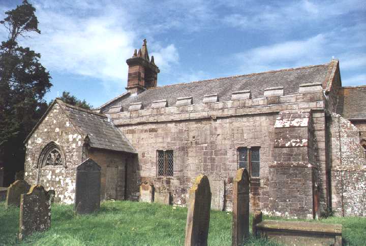 Saxon architecture4. The advowson was
granted by Sabilla de Valoncois, and Eustacius de Stuteville, to the prioress and nuns of
Rossdale, in Cleveland; and in 1290, bishop Irton endowed the vicarage, ordaining
that the vicar should keep in his house three priests and one sub-dean. It is valued, in
the king's books, at £33 4s. 10d. At the enclosure, which was made in 1808, about 650
acres were allotted in lieu of all tithes; those of Torpenhow and Bewaldeth townships
belong entirely to the vicar, for which he has about 329 acres, viz., 240 for the former,
and about 80 for the latter. He has also 40 acres for the tithes of Bothel, and 25 for
these of Blennerhasset; the great tithes of the former belong to Mr. Charlton, for which
he has 80 acres; and for the tithes of Threapland 125 acres have been awarded. The bishop
of Carlisle is patron, the Rev. John Fenton, of Ousby, is vicar, and the Rev. Joseph
Thexton the resident curate. The parish enjoys the benefit of an ancient endowed school,
which was made free in 1686, "and the appointment of the master settled in the vicar,
the heirs of Mr. Salkeld, of Threapland, and a majority of the sixteen select
vestrymen." The school stands at Bothel, and was rebuilt about 40 years ago, by the
16 trustees. It is free to all the poor children of the parish, but the farmers and others
who send their children to it pay 2s. 6d. per quarter. The endowment produces about £50 a
year. The poor of the parish receive £10 a year in bread, the bequest of Mr. Addison, in
1702; those of Bewaldeth, £1 13s. 4d. as the interest of £40 left by John Simpson in
1753; and those of Blennerhasset, £10 14s. 6d., arising from land left by Richard Bouch,
in 1713. Joseph Birbeck, Esq., who died in 1840, left the interest of £80, to be
distributed every Sunday in bread to the poor of the parish.
Saxon architecture4. The advowson was
granted by Sabilla de Valoncois, and Eustacius de Stuteville, to the prioress and nuns of
Rossdale, in Cleveland; and in 1290, bishop Irton endowed the vicarage, ordaining
that the vicar should keep in his house three priests and one sub-dean. It is valued, in
the king's books, at £33 4s. 10d. At the enclosure, which was made in 1808, about 650
acres were allotted in lieu of all tithes; those of Torpenhow and Bewaldeth townships
belong entirely to the vicar, for which he has about 329 acres, viz., 240 for the former,
and about 80 for the latter. He has also 40 acres for the tithes of Bothel, and 25 for
these of Blennerhasset; the great tithes of the former belong to Mr. Charlton, for which
he has 80 acres; and for the tithes of Threapland 125 acres have been awarded. The bishop
of Carlisle is patron, the Rev. John Fenton, of Ousby, is vicar, and the Rev. Joseph
Thexton the resident curate. The parish enjoys the benefit of an ancient endowed school,
which was made free in 1686, "and the appointment of the master settled in the vicar,
the heirs of Mr. Salkeld, of Threapland, and a majority of the sixteen select
vestrymen." The school stands at Bothel, and was rebuilt about 40 years ago, by the
16 trustees. It is free to all the poor children of the parish, but the farmers and others
who send their children to it pay 2s. 6d. per quarter. The endowment produces about £50 a
year. The poor of the parish receive £10 a year in bread, the bequest of Mr. Addison, in
1702; those of Bewaldeth, £1 13s. 4d. as the interest of £40 left by John Simpson in
1753; and those of Blennerhasset, £10 14s. 6d., arising from land left by Richard Bouch,
in 1713. Joseph Birbeck, Esq., who died in 1840, left the interest of £80, to be
distributed every Sunday in bread to the poor of the parish.
Whitrigg, or Whiterigg, said to have been "so called of the waste ground there fashioned like a corn rigg5," is a village and joint township with Torpenhow, from which it is distant one mile south. Its principal landowners are J. Hambleton and J. Railton, Esqrs.; but Sir Wilfred Lawson is lord of the manor, which was anciently held by the Brunes, and afterwards by the Skeltons, of Armathwaite. Here that lofty green hill, called Caer Mot6, on which, Mr. West says, are manifest vestiges of a square encampment enclosed in a double fosse, extending from east to west, 120 paces. It is subdivided into seven cantonments, and the road from Keswick to old Carlisle has crossed it at right angles. On the northern extremity of the hill are the remains of a beacon, and a smaller encampment, having a fosse and rampart of 60 by 70 feet. This camp commands a view of Blatum Burgii, Bowness, Oleanum, Old Carlisle, and of the whole extent of Solway Frith7, so that it "would receive the first notice from any frontier town, where the Caledonians made the attempt to cross the Frith, or had actually broken in upon the province."
Bewaldeth, or Bowaldeth, forms a joint township with Snittlegarth, and lies behind the lofty mountain, called Binfell8, two miles N. of the foot of Bassenthwaite lake, and four miles S.S.W. of Ireby. It was a dependant manor of Allerdale, and granted by Waldeof, to Gilnim, whose posterity assumed the local name of Bowet. The Mulcasters held it for nearly 400 years, until sold by Bensen Highmore to the late James Spedding, Esq. Snittlegarth, now the seat and property of Joseph Railton, Esq., is supposed to have been formerly a village of considerable magnitude.
Blennerhasset village, and joint township with Kirkland, stands on the banks of the river Allen9, seven miles S.W. of Wigton. Here is an Independent chapel, erected in 1828, at a cost of £240, of which £100 was given by Mr. Dawson. The manor was successively held by the Mulcasters, Moricebys, and the Pickerings, "whose heiress sold it to Thomas Salkeld, of Whitehall, to be held in capite by a third part of a knight's fee, 12s. cornage, 6½d. seawake, and puture."
Kirkland manor belonged also to the Salkeld family, who had it granted to them after the dissolution of the priory and convent of Rosdale10. It was let, on a lease of 999 years, by Launcelot; father of Sir Francis Salkeld, for £6 15s. 1d. per annum; each tenant being subject, every 21 years, to a 20d. fine, called a gressom on which new leases are taken, and a heriot, on change by death.
Bothel11 village stands on the side of an eminence, on the Wigton and Cockermouth road, one mile S.W. of Torpenhow. Here was formerly kept the watch for seawake, on which account it was named the Bode, or Both-hill. It was a demesne of Allerdale, till given by Waldeof to Gamel, son of Brun, in the time of Henry I. His mansion was at Brunskeugh, beneath the river Eden, near the wastes, whereupon his son, Radulph, was called Radulphus de Feritate, Rauf of the wastes.
The manor, which forms a joint township with Threapland, after passing through several families, was sold to various freeholders. A strong spring rises here, and runs through the village. It is said in Housman's notes, "the old inhabitants assert, with confidence, that the stream ran blood on the day of king Charles's martyrdom12."
Threapland (contentionis terra)13 is a village, seven miles N.N.E. of Cockermouth. The manor, says Hutchinson, "passed through several purchases to Roger Greg, Esq., of Mirehouse, whose heiress married (John) Storey, vicar of Dalston." He calls it a "customary manor, arbitrary fines, boons, and services."
Mannix & Whellan, History, Gazetteer and Directory of Cumberland, 1847