The manor, which comprises the whole parish, was first annexed to the royal forest of Inglewood, by Henry II, who received a grant of it from Alan, second lord of Allerdale, and was called Westward, from its being the western ward of the forester's charge within the forest. It continued in the Crown till 1344, when Edward III granted it to Thomas Lucy, on his marriage with the king's cousin. It subsequently passed to the Percys, and from them to the Earl of Egremont, so that general Wyndham is the present lord, having succeeded to the late Earl's estates in Cumberland.
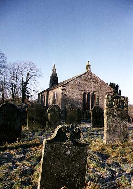 The parish church,2 which is a neat
edifice, with a small tower, stands on a piece of elevated ground, overlooking a deep
ravine, in the hamlet of Church Hill, and in Stoneraise township, three miles S. of
Wigton. In the west end is a monument, dated 1648, in memory of Richard Barwise, of Isle
Kirk Hall, and his wife Frances. The benefice is a curacy, certified to the governors of
queen Anne's bounty, at £23, and returned, in 1835, as of the average value of £99, in
the patronage of the dean and chapter of Carlisle, and incumbency of the Rev. Robert Wood,
who has a commodious residence here, and five acres of ancient glebe, together with 40
acres, allotted at the enclosure of the commons, in 1822, which, with the interest of a
Parliamentary grant of £1200, £22 a year from the ecclesiastical commissioners, £20 a
year for performing service every Sunday afternoon at the Chapel of Ease, Easter dues,
surplice fees, &c., make the living worth about £140 per annum. At the enclosure, for
which an act was obtained in 1811, there were 1408 acres awarded to the dean and chapter,
in lieu of all tithes, viz., 893½ acres for the tithes of the common land, 67 acres as a
modus for the tithe of meal, 38½ acres for the tithe of geese, and 49 acres in lieu of
the tithe of wool and lamb.
The parish church,2 which is a neat
edifice, with a small tower, stands on a piece of elevated ground, overlooking a deep
ravine, in the hamlet of Church Hill, and in Stoneraise township, three miles S. of
Wigton. In the west end is a monument, dated 1648, in memory of Richard Barwise, of Isle
Kirk Hall, and his wife Frances. The benefice is a curacy, certified to the governors of
queen Anne's bounty, at £23, and returned, in 1835, as of the average value of £99, in
the patronage of the dean and chapter of Carlisle, and incumbency of the Rev. Robert Wood,
who has a commodious residence here, and five acres of ancient glebe, together with 40
acres, allotted at the enclosure of the commons, in 1822, which, with the interest of a
Parliamentary grant of £1200, £22 a year from the ecclesiastical commissioners, £20 a
year for performing service every Sunday afternoon at the Chapel of Ease, Easter dues,
surplice fees, &c., make the living worth about £140 per annum. At the enclosure, for
which an act was obtained in 1811, there were 1408 acres awarded to the dean and chapter,
in lieu of all tithes, viz., 893½ acres for the tithes of the common land, 67 acres as a
modus for the tithe of meal, 38½ acres for the tithe of geese, and 49 acres in lieu of
the tithe of wool and lamb.
The two schools, at Church Hill and the Craggs, receive the sum of £6 a year for the education of six poor children of the parish, being the rent of the land purchased in 1765, with £60 left in 1754, by Mr. John Jefferson. The interest of £20 was bequeathed, in 1778, for the instruction of one free scholar at the Church Hill school, provided the curate is not the master; but if he be, the money, in that case, is to be given to the poor. In 1846, the interest of £600 was left by the late Mr. Joseph Hodge, for the education of poor children of this parish; the poor of which have also three other benefactions, amounting to £6 12s. 6d.
Stoneraise contains also the small hamlets of Foresterfield, Red Dial, and Warble-bank, with several dispersed and pleasantly situated dwellings, bearing different names; among which are, Greenhill House, Forest Hall, Rays Lodge, Stoneraise Place, Greenrigg, Cunning-garth, Westward Park, &c., &c. Greenhill House is a large mansion, rebuilt about four years ago, two miles S. of Wigton; and the others are from 1½ to 2½ miles from the same town. This division, though having no village of its own name, is the largest and most fertile in the parish - comprising 3484 acres of rich freehold land, rated at £4412 15s.; a great part of which belongs to resident yeomen. The other principal land owners are general Wyndham, Miss Matthews, Robert Jefferson, Joshua Rigg, M.D., John Stead, Sir Henry Fletcher, Bart., F.L.B. Dykes, Esq., and Mr. John Barnes. At the Red Dial Inn, 1½ mile S. of Wigton, are held the manor courts; and here the magistrates meet monthly, for the appointment of surveyors of highways, overseers of the poor, the granting of licences to publicans, and the transaction of other business connected with the ward. Fairs are held at Red Dial hamlet annually, on the 1st of August, for sheep and wool; and on the 21st of September, for sheep only.
Islekirk Hall - now a farm house, in a deep valley, near a small rivulet, about one mile W. of the church, and three miles S. of Wigton - is also in this division, and is said to be a corruption of St. Hilda's Kirk - from an hermitage, or religious house, which stood here, dedicated to that saint; but how it was endowed, or by whom founded, there is no evidence to show. That it existed, and was of some importance, in the 12th century, appears from its being granted by king John to the abbey of Holme Cultram, and from the veneration "paid to it by the monks in founding there a chapel or oratory, which in course of time obtained parochial rights, though surrounded by a forest, which, in its original nature, was extra parochial." After the dissolution of the religious houses, the lands and tenements here, which belonged to Abbey Holme, were granted by Henry VIII to Thomas Dalston, "he rendering for the same, at the feast of St. Michael the Archangel, 15s. 8½d." In the next year it was conveyed to Anthony Barwise, and was afterwards the property and residence of the great Richard Barwise, of gigantic stature, who, it is said, used to display his herculean strength by walking round the hall yard, carrying, at arms' length, his wife on one hand, and a stone of prodigious size on the other. There is also a tradition that he once walked majestically along Eden Bridge, at Carlisle, with his fair spouse seated in his hand and elevated over the battlements. There is still to be seen, at Islekirk, a huge stone, which it is asserted he could throw with ease the whole length of the court yard, though there are few men, in this degenerate age, who can raise it from the ground. He died, 13th of Feb., 1648, in the 47th year of his age. Stoneraise is also the division in which lies the Roman station known by the name of Old Carlisle3, 1½ mile N. of the church, and the same distance S. of Wigton, on the site of a Roman road leading from the city of Carlisle to Ellenborough. Camden says :- "Below the monastery (Holm Cultram) the bay receives little Waver, increased by the Wize4, a small river, at the head of which the melancholy ruins of an ancient city teach us that nothing in this world is out of the reach of Fate. For spying an enemy you could not have a more convenient place, for it is seated on a high hill, which commands a free prospect round the country." Hutchinson says :- "The remains of the station are very extensive, foundations of innumerable buildings being scattered over many acres, as well within the vallum as on every hand without, except to the westward, where the ground descends precipitately to the brook Wiza. The station is an oblong square, 170 paces in length, and 110 in breadth, with obtuse angles, defended by a double ditch, with an opening or approach in the centre of each side : the whole ground discovers a confusion of ruined edifices." Sacrificial instruments, statues, images, altars, coins, inscriptions, and many other relics of antiquity, have been found here at different times, in great numbers; several of which are now in the possession of Miss Matthews, of Wigton Hall; whose brother, the late Rev. Richard Matthews, took a great interest in the preservation of the station. Many of the inscriptions found are inserted in Hutchinson's Cumberland, and amongst the rest are the following to two local deities :-
DEO |
DEO |
In 1845, a Roman altar was dug up here, 3 feet 2 inches high, 1 foot 5 inches broad, and 5 inches thick, bearing the following inscription, which records its dedication to the goddess Bellona, by Rufinus, prefect of the cavalry of the Augustan ala (or wing), and his son Lainianus.
DEAE BEL
LON. Æ. RVFI
NUS. PRAE
EQ. ALÆAVG
ET. LAINIA
NVS. FIL.
It now stands at the Red Dial inn, in this parish, and is the property of Mr. John Stead, of Cummersdale Print Works.
Antiquaries have variously understood this Roman encampment; but Mr. Horsley and Mr. Warburton, with some plausibility, assert that it was the Oleanum, where the Ala Herculea encamped in the time of the Notitia5, as well as the Ala Augusta, under the emperor Gordian6. "On the level green, a little below the station," says Hutchinson, "foot races are still kept up, and the distances are denoted by hillocks, on one of which a post is now fixed. We conceive, in this race, is preserved a Roman custom, and the ancient goals are pointed out to us by the hillocks; which are, apparently, artificial, but too small to be tumuli7. Population of Stoneraise, 446.
Brocklebank township, or quarter, forms the southern extremity of the parish, and is a hilly district, bounded on the south by Catland and Warnell Fells. Besides the hamlet of Brocklebank, which is about five miles S.S.E. of Wigton, the township also contains the small hamlets of Clea green8, Reathwaite, with several dispersed dwellings, amongst which are Clea-hall, now a farm house, with fine prospects, the property of Sir Henry Fletcher, Bart., one of whose ancestors received it by intermarriage with an heiress of the Musgraves, of Crookdake. The other principal landowners are general Wyndham (the largest), the earl of Lonsdale, Mr. J. Westmoreland, Mr. Thomas Milton, and Miss Beaty. It contains 2886 acres, rated at £1679, and its population in 1841 was 171 souls.
Rosley9 township has a small village, occupying a delightful situation on the southern acclivity of an eminence, five miles E.S.E. of Wigton, and nine miles S. by W. of Carlisle. It has long been noted for its large horse and cattle fairs, which are held on Whitmonday, and on every alternate Monday after till Lammasday. "These meetings are much regarded by the breeders of 'stock' and lack nothing that any other fair can boast of, as may be seen in Evan Clarke's10 humorous description of them in his Cumberland poems." Two other fairs for cattle, horses, and sheep, established here in 1845, are held on the 21st of April, and on the 3rd Monday in October; these are also likely to flourish, especially the former, which is on the third day before the great fair at Penrith. Rosley green is a large piece of common, commanding extensive and panoramic views.
The hamlets of Brackenthwaite and Craggs11, the former 2½, and the latter 3 miles S.E. of Wigton, are also in Rosley quarter, which contains 2845 acres of freehold land, rated to the poor, in 1847, at £2851 10s.,belonging to Sir Wastel Brisco, General Wyndham, the heiresses of the late Sir P. Musgrave, Henry A. Lea, Esq., Mr. Richardson, Mr. Bewley, and several resident yeomen. In the village of Rosley is a neat dwelling, the residence of Mr. Joseph Rook, who also owns the heights, an estate in Woodside quarter, left to him by the late Joseph Hodge, Esq., of Wigton. Population of Rosley, 279.
Woodside township, or quarter, comprises the hamlets of Westwood-side, Eastwoodside12, East and West Curthwaite, Howrigg, and the Heights, extending from 2½ to 5 miles east of Wigton, and containing 2445 acres, rated at £3194 5s. Sir W. Brisco is the largest proprietor in this township; but Mr. John Gibson, Miss Lowry, and Mr. Joseph Rook, have estates here, besides several resident yeomen. Twenty houses is an undivided lordship, of customary tenure, under arbitrary fines, and belongs to Sir W. Brisco, Sir W. Lawson, and the Duke of Devonshire, the latter receiving a free rent. A meal tithe was levied on this manor by one of the lords of Inglewood Forest, for the support of the hounds which were kept at Forester Fold, and the inhabitants were subject to its payment, till the enclosure of the commons, when land was allotted in lieu thereof. They are toll free at Rosley, Wigton, and Penrith. At the Heights is a chapel of ease, built in 1840, at a cost of about £700, raised by subscription, except £70 obtained from the incorporated society. It is endowed with £100, secured on a railroad debenture, the interest being £5 per annum, "and the dean and chapter of Carlisle will augment the living of Westward, with a stipend of £15 a year, in consideration of the duty performed at this chapel," which is a great desideratum to the inhabitants of this district. Its site was given by the late Mr. Hodge. Previous to the enclosure of the common land, several trenches and other vestiges of encampments could be traced in this parish, particularly near the Heights; but most of them have been levelled, and large quantities of stone removed from their sites. Population of Woodside, in 1841, 415.
Mannix & Whellan, History, Gazetteer and Directory of Cumberland, 1847