The Abbey township has a pleasant village, on the east bank of the Waver, six miles W. by N. of Wigton, and 17 miles W. by S. of Carlisle. It had anciently a weekly market on Thursday, and there are still two fairs held here annually for horses and cattle, on the 29th of October, and the Tuesday before Whitsuntide.
There was here a richly endowed Abbey of Cistercians, said by several writers to have been founded by prince Henry, son of David, king of Scotland, about the year 1150, and dedicated to the Virgin Mary. From Leland's Collect. it appears to have been founded by Alanus, son of earl Waldeof; "but from the crown rolls, in the time of Edward I, another suggestion arises that it was a foundation of king Henry I," that Alanus only restored the infant monastery, "and that the Scotch monarch and his son were only the third in succession of benefactors," and gave it two-thirds of the parish of Holme Cultram, the monks having previously received the other third from Alanus. The abbots of this large monastery were so much regarded by the sovereigns of England , that they were especially summoned to several parliaments2 in the reigns of Edward I and II - "a privilege not due to them, as was the case of mitred abbots;" and they received from the crown, at sundry times, divers privileges and immunities - exemptions from the toll, &c. Being now possessed of the whole island of Holme Cultram and Raby ("totam insulam de Holme Cultram et Raby"), "the monks presently erected five granges for husbandry, at Raby, Mawbergh, Skinburne, Culshaw, and Newton Arlosh; and they soon after were endowed with many other lands, tenements, and hereditaments."At the dissolution of the religious houses, the monastery
was surrendered to the crown, in the 26th Henry VIII, being then valued at
£427 19s. 3d., according to Dugdale, and £537 3s. 7d., according to Speed; either of
which sums, in the present value of money, would amount to upwards of £2,000 per annum.
Borrowdale, the last abbot, 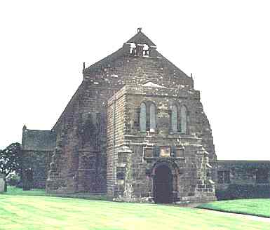 was appointed to the rectory, then
instituted, and had a book returned to him containing an account of all the tithe,
&c., which had been paid to the monastery. He died in the first year of the reign of
queen Mary, who granted the rectory to the chancellor, masters, and scholars of the
university of Oxford, "from whom it hath been constantly leased out."
was appointed to the rectory, then
instituted, and had a book returned to him containing an account of all the tithe,
&c., which had been paid to the monastery. He died in the first year of the reign of
queen Mary, who granted the rectory to the chancellor, masters, and scholars of the
university of Oxford, "from whom it hath been constantly leased out."
Little or none of the monastic ruins now remain, save what have been converted into the
parish church. The benefice is now a vicarage, to which a graduate clergyman
is appointed by the university; and that office is now held by the Rev. Joseph Simpson,
M.A., who resides at the vicarage house, a large and handsome mansion, about half-a-mile
from the church. After a protracted chancery suit, in respect of the tithes, it has just
been awarded that the parish shall pay £900 a year, commencing on the 1st of
January, 1848 - all property, whether occupied by landlord or tenant, to be equally
assessed, until the apportionment be made, and each party to pay their own expenses. The church
is a large and beautiful fabric, conveniently seated; with handsome galleries. The west
porch is supposed to have been built by Robert Chamber, abbot, in the year 1507, but the
whole "hath undergone many singular mutilations." Before the dissolution, Bruce,
the earl of Carrick, and several other Scotch nobles, were buried in the abbey.
The Abbey House, and the extensive farm belonging to it, is the property of the Earl of Lonsdale. This township contains 868 inhabitants, 5,330 acres (rated at £4,960), and the following hamlets:-
Abbey Cooper3, anciently Cowbier, a hamlet one mile W. from the abbey, is said to have to have been the place where the monks kept their cows, and hence its name. Akeshaw4, a small hamlet on the north bank of the Crummock beck, 5 miles S. by W. of the abbey. Aldoth, near 3 miles W. by S. of the abbey, is a hamlet consisting of a few farm houses. Brownrigg hamlet is about 2 miles N., occupying a pleasant situation on the west bank of the Waver, near its confluence with the Wampool; High Laws5 hamlet, 2 miles S.W.; Kingside Hill hamlet, 1 mile N.W.; Southerfield hamlet, extending from 1 to 2½ miles S., and Swinsty hamlet, a short distance S. of the abbey. In the latter the monks are supposed to have kept their swine.
East Waver township is separated from the rest of the parish by the river Waver, and extends to the mouth of the Wampool, from half-a-mile to 6 miles N.E. of the abbey. It contains 5716 acres, rated at £3800, mostly the property of resident yeomen; but the earl of Lonsdale and a few other non-resident families have small estates here. The ancient farm house called Raby Coate, which belongs to the executors of the late Rev. J. B. Backhouse, stands 1½ miles N.E. from the abbey, and was formerly the seat and property of the Chambers, whose arms and other inscriptions are in different parts of the building. The following hamlets are in this township :- Angerton, 6 miles N.E. of the abbey, adjoining the village of Kirkbride. Newton Arlosh, or Long Newton, a scattered village, 4 miles N. by E. of the abbey, and 7 miles N.W. of Wigton. This place is said to have been the ancient capital of the parish, and its church the original parochial structure - which was very small, being only 9 yards by 4, exclusive of the tower, which, it is supposed, was a place of refuge. The old fabric, after having lain for many years in ruins, was restored in 1843, with the strictest attention to the ancient style of ecclesiastical architecture; when rebuilding this edifice, a heap of human bones, skulls, &c., was found in a corner of the building; which circumstance, together with the thickness of its walls, seems confirmatory of the opinion that it was once deemed a place of safety and defence. Several respectable families in the neighbourhood continue to bury their dead in the church yard.
Moss Side hamlet, 2½ miles N.E.; Saltcoates hamlet, 2½ miles N.E.; and Slightholme6 hamlet, 2½ E. by N. of the abbey. A place called Wedholme Wood, in this township, was granted by queen Elizabeth to the copyhold tenants of Abbey Holme, for maintaining the sea dike bank, near Skinburness. Population of East Waver, 470.
Low Holme township is the largest division of the parish, comprising a semicircular district, extending N. and W. from the abbey, surrounded on three sides by the ocean, and terminating on the north by a narrow tongue of land called Grune Point. It contains the village of Skinburness, with several detached hamlets - 6290 acres of fertile land, rated at £5666., and a population of 933 souls. Its principal landowners are Charles Joliffe, Esq., the earl of Lonsdale, and William Hodgson, Esq.; but there are many resident yeomen here, several of whom have neat and commodious dwellings.
Black Dyke7 hamlet, 2½ miles W. by N.; Blitterlees village, 5 miles W. by N.; Calvo (or Culshaw) hamlet, 3 miles N.N.W.; East Coate8, 4½ miles N.W.; Causeway Head9, 4½ miles W. by N.; Green Row10 hamlet, 4½ miles W.N.W.; Hayrigg, 4 miles W.; Seaville hamlet, 2 miles N. by W.; Silloth11 hamlet, 4 miles N.W.; Skinburness, 5 miles N.W. by N.; Wath, 4 miles N. by W.; and Wolsty hamlet, 5 miles W. of the abbey - are all in this township.
At Causeway Head is a neat chapel of ease, erected in 1844-5, and dedicated to St. Paul. There is another chapel of ease (built in the same year) in St. Cuthbert's township, and dedicated to that saint. They are neat Gothic edifices, having each upwards of 300 sittings, all of which are free and unappropriated; and the united cost of both, including the school attached to St. Cuthbert's (which cost £320 12s. 9d.), was about £1900.; raised by subscription, aided by a grant of £400 from the Church Building Society, and small grants from the Privy Council of Education, and the National Society. Each has ample burial ground, and subscriptions for the erection of a parsonage house are now being collected. The Rev. Isaac Bowman is the officiating minister.
Green Row is a small hamlet, pleasantly situated near the sea shore, and commanding fine prospects of Criffel mountain and the Scottish coast. Here is a large seminary, called Green Row Academy, established, about 70 years ago, by Mr. John Drape; who died in 1795, when he was succeeded by Mr. Joseph Saul, who conducted this establishment for nearly 50 years, and under whose superintendence it rose to great celebrity - as many as 150 students, not only from Britain, but also from the West Indies and different parts of Europe, having been accommodated in the house at one time. He died in 1842, deeply lamented by a large circle of friends, chiefly of his own training; and, as a testimony of the esteem in which he was held, a number of his pupils erected, in 1845, a beautiful marble monument to his memory, in the abbey church. His son, Mr. John Saul, is the present head master, and is assisted by competent teachers in the different branches of a comprehensive system of classical and commercial education.
Seaville is a small but pleasant village, on the west bank of the Waver. In this vicinity are several farms, bearing different names, occupied by their owners; but the ancient farm house called Seaville Coate12 is the property of James Losh, Esq., of Newcastle.
Silloth hamlet is situated on the coast, called Silloth Bay, and is the property of Charles Joliffe, Esq.
Skinburness is a pleasant village and considerable bathing place, near Grune Point, commanding an extensive view of the Solway Frith13 and Scottish hills, &c. Here is a comfortable inn, and a few neat lodging houses, for the accommodation of the visitors who resort hither during the summer, for the purpose of sea bathing. Several neat houses have been erected here, within the last few years, amongst which is one belonging to Mr. Samuel Rigg, of Wigton, which he occupies during the bathing season. In the 13th century there stood here, on the edge of a bay, a considerable market town, by the charter of Edward I, declared to be a free borough, as will be seen by the following quotations.
"The village of Skinburnesse, within the boundaries of the Island of Holme, shall be a free borough, and the men inhabiting there free burgesses, with all liberties and free customs for ever, so that the said borough be kept by some faithful man chosen by the abbot and his brethren. That all merchants might resort thither with their merchandise by land and water; that there should be a weekly market on Thursday, and a fair every year." It is also mentioned as having been the chief place for the king's magazines in these parts, on Scotch expeditions.
But the calamities the borough had soon after sustained, caused the abbot to apply to the crown to have a market and fair at Kirby Joan14, and in 1305, say Nicholson and Burn, we find it thus mentioned in the parliamentary records :- "At the petition of the abbot, requesting that whereas he had paid a fine of 100 marks to the king, for a fair and market to be held at Skinburnesse, and now that town, together with the way leading to it is carried away by the sea, the king would grant that he may have such fair and market at his town of Kirkeby Johan, instead of the other place aforesaid, and that his charter upon this may be renewed. It was answered, let the first charter be annulled, and then let him have a like charter in the place as he desireth." Hutchinson says "the breaking in of the ocean, whereby the town of Skinburness was laid waste, had happened after the year 1301; for in that year, bishop Halton, in consideration that the inhabitants were at a great distance from all places of divine worship, granted a power to Holm Cultram, to build a church there, with proper endowment, and all parochial rights;" but it is supposed this power had never been carried into execution, for in 1303, the same bishop granted to the abbot and convent power to build a church at Arlosh, with all parochial rights, and authority to nominate a priest for institution, and a salary of £4 a year.
Wolsty hamlet is situate near the coast, and here stood Wolsty or Wulsty Castle, mentioned by Camden, formerly a building of great strength, encompassed by a large and deep ditch or foss, crossed by a draw bridge, and erected by the abbots as a place of security for their treasures, books, and charters, against the sudden incursions of the Scots; and here, it is said, were kept the "magic books of Michael Scot, till they were mouldering into dust." This monk, who lived about the year 1290, was astrologer to Frederic II, emperor of Germany; and applied himself so closely to philosophy, mathematics, and other abstruse parts of learning, that he was looked upon by many as a conjuror. Camden says that this neighbourhood seems to be the Moricambe mentioned by Ptolemy, "for the estuary is crooked, and Maricambe signifies, in British15, a crooked sea." The walls of the castle were 12 feet thick, and the site, as now visible, is 45 yards from east to west, and 36 from north to south. The ditch, though filled up, may still be traced16.
St. Cuthbert's township, which comprises the south-western extremity of the parish, comprehends the hamlets of Beckfoot, 6 miles W.; Cowper, or New Cowper, 5½ miles S. by W.; Etherside17, 7 miles S.W. ; Mawbray, 7 miles W.S.W.; New Mawbray, 5 miles W. by S.; Pelutho, 3 miles W.S.W.; and Tarns, 4 miles W.S.W. of the abbey. The population of this township, in 1841, was 766; and it contains 5884 acres of land, rated at £4300, mostly belonging to resident yeomen, of whom Mr. Thomas Barnes, of Mawbray, is the largest.
Beckfoot village is supposed , from the many foundations found in its vicinity, to have formerly been larger; and here is a place called Castlefields, said to have been the site of an ancient castle . The beach, near Beckfoot, is well-adapted for sea-bathing, though frequented by very few visitors. Here is a Friends' Meeting House attended by a few of that respectable body.
Mawberg, Mawbray, or Malbray, is situate near the sea shore, 2 miles above Allonby, and here is supposed was a Roman Camp, or fort; "but the vallum," says Hutchinson, "has been defaced, and corn now grows upon the site of it; though some of the old inhabitants remember part of the wall standing." On a stone, said to be taken from the wall, was the following inscription :-
L. TA. PRAEF. COH. II PANNON FECIT
"Probably this inscription, if fully recovered, would have shewn us that the Spaniards18 built the wall, or some public edifice there, and is of no greater importance." ‡ The Wesleyans have a chapel here.
New Mawbray is a pleasant village, near Beckfoot.
Pelutho hamlet stands on the brow of an eminence, commanding good views of the Solway Frith and Scottish hills, and here are a few neat houses occupied by their owners. At its east end is the small hamlet of Foulbridge19 and Gillbank, 2½ miles, and a little to the south is the small hamlet of Tarns, 4 miles W. of the abbey. Here is a small lake or tarn, covering about 50A.
The Rev. Joseph Wise, son of a respectable yeoman in this parish, published several volumes of poems, some of which possess considerable merit, but it is evident he was not born a poet. "Poeta nascitur et non fit." He died in December 1810. The Rev. Thomas Jefferson, who was for many years curate of Cockermouth, and who died in 1768, at the age of 93, is said to have been a native of Holme Cultram. He published a sermon on the capture of Quebec20, and sundry poetical jeux d'esprits.
* Cultram is supposed to be a corruption of Cultam terram, which is an abbreviation of Culturam terram, meaning cultivated land.
† Skinburness, Calvo, and Border Marsh contain 1081 acres, divided into 400 stints of cattle gates, of which 212 belong to Low Holme; 110 to the abbey; and 87 to St. Cuthbert's. Long Newton Marsh contains 387 acres, divided into 107 stints.
‡Hutchinson.
Mannix & Whellan, History, Gazetteer and Directory of Cumberland, 1847