The Parish Church, dedicated to St. Michael5, stands on a beautiful eminence, near the rectory house, in the
township of, and about 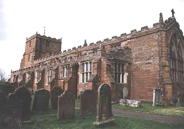 half-a-mile S. from Longtown. "It is presumed," says
Hutchinson, "this point of land was called Arthur's Head6,
a name now corrupted to Arthuret, and engrafted on the parish." The present Gothic
fabric was built in 1609, "by the help of a charity brief," but the persons
employed in the building absconding with a considerable part of the money, the tower was
left unfinished till about the year 1690, when it was completed, through the exertions of
the Rev. Hugh Todd, who possessed the living from 1688 to 1728. It consists of a nave,
side aisles, chancel, and tower. In 1750 it was new roofed, flagged, and slated, by the
hon. Mary Graham. "It appears," says Hutchinson, "to have been part of the
possessions of the abbey of Jedburgh, in Scotland; but by whom it was granted thereto doth
not appear. It is presumed that Arthuret was given to this Scotch abbey whilst the county
of Cumberland was under that crown. It was seized by king Edward III on the principles
that the abbot of Jedburgh was in rebellion." The benefice is a rectory (valued in
the king's books at £1 2s. 1d.), in the patronage of Sir James Graham, Bart., and in the
incumbency of the Rev. William Graham, M.A., for whom the Rev. H. Griffin, B.A.,
officiates. It was certified to the ecclesiastical commissioners as of the
half-a-mile S. from Longtown. "It is presumed," says
Hutchinson, "this point of land was called Arthur's Head6,
a name now corrupted to Arthuret, and engrafted on the parish." The present Gothic
fabric was built in 1609, "by the help of a charity brief," but the persons
employed in the building absconding with a considerable part of the money, the tower was
left unfinished till about the year 1690, when it was completed, through the exertions of
the Rev. Hugh Todd, who possessed the living from 1688 to 1728. It consists of a nave,
side aisles, chancel, and tower. In 1750 it was new roofed, flagged, and slated, by the
hon. Mary Graham. "It appears," says Hutchinson, "to have been part of the
possessions of the abbey of Jedburgh, in Scotland; but by whom it was granted thereto doth
not appear. It is presumed that Arthuret was given to this Scotch abbey whilst the county
of Cumberland was under that crown. It was seized by king Edward III on the principles
that the abbot of Jedburgh was in rebellion." The benefice is a rectory (valued in
the king's books at £1 2s. 1d.), in the patronage of Sir James Graham, Bart., and in the
incumbency of the Rev. William Graham, M.A., for whom the Rev. H. Griffin, B.A.,
officiates. It was certified to the ecclesiastical commissioners as of the 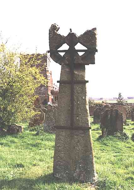 average annual value of £687. "In the church yard is a
rude cross,7 with a pierced capital, in the form and figure of
the cross of the knights of Malta; and it is probable it was erected by one of that
order." Near to this place lie, it is supposed, the remains of poor Archy
Armstrong, jester to James I and Charles I; "and, by accident suitable to his
profession, the day of his funeral was the 1st of April." He long shot his bolt with
great applause, but was at length banished from court and degraded, by having his motley
coat pulled over his head, for presuming to vent his wit on archbishop Laud, of
Canterbury, after that haughty prelate had failed to introduce the liturgy into Scotland.
It is said by some that he was a native of this parish. There is also in the church yard a
monumental inscription to lieut. William Graham, who served the crown of England in the
reigns of Elizabeth, James, Charles I and II, and died, A.D. 1657, in the 97th year of his
age. The rectory house was built in 1765, at a cost of £300, by the Rev. Mr. Usher, the
then rector, on the site of the old one, which was erected about the year 1680.
average annual value of £687. "In the church yard is a
rude cross,7 with a pierced capital, in the form and figure of
the cross of the knights of Malta; and it is probable it was erected by one of that
order." Near to this place lie, it is supposed, the remains of poor Archy
Armstrong, jester to James I and Charles I; "and, by accident suitable to his
profession, the day of his funeral was the 1st of April." He long shot his bolt with
great applause, but was at length banished from court and degraded, by having his motley
coat pulled over his head, for presuming to vent his wit on archbishop Laud, of
Canterbury, after that haughty prelate had failed to introduce the liturgy into Scotland.
It is said by some that he was a native of this parish. There is also in the church yard a
monumental inscription to lieut. William Graham, who served the crown of England in the
reigns of Elizabeth, James, Charles I and II, and died, A.D. 1657, in the 97th year of his
age. The rectory house was built in 1765, at a cost of £300, by the Rev. Mr. Usher, the
then rector, on the site of the old one, which was erected about the year 1680.
Longtown is a small but pleasant market town, situate on the banks of the river Esk, near its confluence with the Liddel, over which is a stone bridge, 9 miles N. of Carlisle, 20 miles N.E of Wigton, and 308 N.N.W. from London, on the mail road to Edinburgh. It has a very respectable appearance; the streets are spacious and regular, the houses built in the modern style; and its situation is exceedingly salubrious. The market day is Thursday, but the business done is very trifling. A horse fair is held on the Thursday before Whitsuntide, but the cattle fair, formerly held on the Thursday before September 30th, has been for some time discontinued. In 1841 the township contained 1990 inhabitants, upwards of 200 of whom are weavers in the employ of the Carlisle manufacturers. The town stands on the south bank of the Esk, and on the west side of the Netherby estate, which is held on a tenure of building leases, and has been raised to its present state by the liberality of Dr. Graham, grandfather to Sir James. Longtown has suffered much by the opening of the Glasgow road in 1819, but now that an Act of Parliament has been obtained for a branch line from the Caledonian Railway to this town and Connobie8, in Scotland, and, as it is intended to apply for another Act to connect this with the Newcastle and Carlisle Railway, at Milton Station, near Brampton, it is understood the proprietor of the Netherby estate purposes, at no distant period, giving every encouragement to the establishment of manufactures in the town and neighbourhood. By the construction of these lines coal and lime of the very best quality can be supplied with great facility to extensive districts, both of England and Scotland. Dr. Graham also directed his attention to the education of his tenants' children, for which purpose he erected schools in this and the surrounding townships. There are now four schools in this parish, and four in Kirk-Andrews, endowed with £40 a year, left by lady Widdrinton, and secured upon the lands at Burnfoot, of which sum the school in the Moot hall, in this town, receives £8, and the schools in the other townships of the parish £4 each, per annum. Here is also a female school, supported by lady Graham and the rector, in which 18 poor girls are taught and partly clothed. The places of worship in the town are - a Presbyterian Chapel, built in 1800, and now under the ministry of the Rev. John Inverarity, and a neat chapel belonging to the United Presbyterians, erected in 1834, and now under the pastoral care of the Rev. Peter Carruthers. Here is a lodge of Freemasons, one of Foresters, and two other Friendly societies; but it is somewhat remarkable that though the parish contains upwards of 2850 inhabitants, there never yet has been a resident attorney in the town.
Longevity - 1845, a woman died at a place called Peth9, near this town, at the advanced age of 100 years; in 1816, another female died in the neighbourhood aged 99 years and 9 months; and, in the same year, 40 individuals died in this district, whose united ages amounted to 3314 years, being an average of nearly 83 years each.
The Workhouse for the Longtown Union stands about two miles east of the town, and was built in 1837, at a cost of £3000, adjoining the old one, which was erected in 1821. It is a large and convenient edifice, of hewn stone, capable of accommodating 150 paupers, but the average number of in-door paupers, during the year 1847, was only about 60, and the number of out-door recipients, in the same year, averaged about 100. The Union comprises the following parishes and townships, viz., Arthuret, Bellbank, Bewcastle, Hethersgill, Kirk-Andrews (Middle), Kirk-Andrews (Nether), Kirk-Andrews (Moat), Kirklinton (Middle), Nichol Forest, Scaleby, Solport, Stapleton, Trough, and Westlington. It is governed by a board of twenty-one guardians, to whom Mr. Richard Graham is chairman; Mr. T. H. Hodgson, solicitor, clerk; Mr. William Graham, of Nether-house, surgeon to the house, and medical officer to the lower district; Mr. James Garvie, medical officer to the upper district; Mr. Jas. Hope, relieving officer for the upper district; Mr. Joseph Lamonby, relieving officer for the lower district; Mr. Joseph and Mrs. Routledge, master and matron; Mr. Thomas Slater, schoolmaster; and the Rev. John Wannop, of Nichol Forest, chaplain. The right Hon. Sir J. Graham allows 2s. 6d. per week for the purpose of supplying the aged inmates with the luxury of tobacco and snuff. The rateable value of Longtown is £3432 2s. 10d.
Brackenhill township extends from three to five miles E.N.E. of Longtown, on the north side of the river Line. It contains 373 inhabitants, and its rateable value is £1942 18s. 3d. Sir James Graham is the principal land owner, but R. E. W .P. Standish, Esq., of Fairley castle, Berks.10, has an estate here, on which is an embattled tower, bearing date 1584. It adjoins the Brackenhill farm house, and is kept in excellent repair by Mr. Standish. At Chapel Flosh, near the farm called Chapel-town, there was formerly an oratory, denominated the Chapel of Sollom (Solway), "in which, in the year 1343, a league between the Scotch and English, about fixing the limits of both kingdoms, was, in a solemn manner, sworn to and confirmed by commissioners appointed for that purpose."
The small hamlet of Easton, anciently the capital of the parish, is situate in this township, and here stands the school already mentioned.
Lineside township lies on the banks of the Line, and contains only 24 houses and 128 inhabitants, with a few dispersed dwellings, about two miles S.S.E. of Longtown. Its rateable value is £1278 16s.
Netherby township extends from one to four miles N.N.E. of Longtown, and contains 368 souls and the small hamlets of Hallburn and Slealands, with several dispersed dwellings, and Netherby Hall, the splendid seat of the right hon. Sir James R. G. Graham, Bart., M.P., the lord and owner of the great barony of Liddel. This elegant mansion stands on a slight eminence, in a beautiful park, surrounded by rich meadows, woods, and shrubberies, and commands extensive prospects, to the S. and S.W., over fertile plains dotted with hamlets and neat cottages. This superb mansion (together with the pleasure grounds) has been greatly improved by its present owner. It is erected on the site of a Roman station11, where many curious pieces of antiquity have been found, several of which are preserved at the mansion. The word by12 means a habitation; "thus," says Mr. Horsley, "there are three camps, or stations, with this termination, not very remote from one another - Netherby, Middleby, and Overby." The present building was chiefly erected by Dr. Robert Graham, who, while levelling the ground contiguous to the house, discovered a large quantity of Roman remains. The house is elegantly furnished, and the gardens and pleasure grounds are laid out with great taste and judgment; the library contains an excellent collection of valuable works.
Liddel barony, which comprehends both this parish and that of Kirk-Andrews-upon-Esk, "was one of the allotments," says Hutchinson, "made by Ralph de Meschines13 to his descendants, and was by him granted to Turgent Brundey - said to be a Fleming; king Henry I afterwards confirmed the same. It appears that this barony was a member of the honour of Dunstanburgh, in the county of Northumberland." In the reign of king John it was the property of the Stutevilles, to one of whom (William) that king gave the command of Northumberland, Cumberland, and Westmorland, with the supreme government of all their castles. Nichol Forest, within this barony, is said to have derived its name from Nicholas de Stuteville, whose heiress (Joan) carried the family estates, in the reign of Henry III, to Hugh de Wake, lord of Wake. Male issue also failing, the heiress, Margaret, married Edward Plantagenet, earl of Kent, third son of Edward I, whose only issue was Joan, who married Edward, the Black Prince, father of Richard II, "by which means," continues Hutchinson, "some historians allege, this barony became vested in the crown; and others say king Edward III, by purchase from the earl of Kent, obtained it." These possessions appear to have remained with the crown till James I, in the first year of his reign, granted the forest of Nichol, with the manors of Arthuret, Lyddal, and Radlington, to Geo. Clifford, earl of Cumberland, to be held of the crown in capite, under a rent of £100, and the twentieth part of one knight's fee. In this grant, it is expressed, that the premises were parcel of the honour of Dunstanburgh, and duchy of Lancaster. All the Debateable lands14, together with the advowson of the church of Kirk-Andrews, were granted by the same monarch in the eighth year of his reign (1610) to Francis, earl of Cumberland, under the yearly fee farm rent of £150. These lands are described as being bounded by the Solway Sands towards the south, the river Sark towards the west, the Scotch Dyke towards the north, and the Esk river towards the east; containing 2895 acres of meadow and arable land, called Known Grounds; 400 acres of marsh land, 2635 acres of pasture, and 1470 acres of mossy grounds - in the whole, 5400 acres." Francis, earl of Cumberland, sold these territories to Sir Richard Graham, and this sale was confirmed by king Charles I, by letters patent of the 11th of July, in the 4th year of his reign; wherein he was exonerated from one half part of the rent of Nichol Forest, and two thirds of the rent of the Debateable lands, the two rents being reduced to £50 each." These possessions still remain in the family of Graham. The descent of this family is from John, second son of Malice, earl of Monteith, whose mother was a Stuart, and, in her own right, countess of Monteith. This John Grahme, or Graham, "from his expertness in the business of the borders, was surnamed John with the bright sword. On some disgust he withdrew himself from the service of the crown of Scotland, with many of his retainers, and settled in the English borders in the reign of king Henry IV." In 1641, Sir Richard, the purchaser of this barony, was created a baronet, and was so severely wounded at the battle of Edgehill15 that he lay all night amongst the dead. In 1680, his son, Sir Richard, was created viscount Preston of Scotland, and was several times ambassador at the court of France. He was subsequently secretary of state to James II, in whose cause he was convicted of treason, at the Revolution of 1688, but, through the intercession of his friends, was pardoned, and died at Nunnington, in Yorkshire, in 1695, when he was succeeded by his son Edward, as viscount Preston, who died in 1709. The next viscount Preston was Charles, who died without issue in 1739 when the title became extinct, and the estates passed to Catherine and Mary, his father's two sisters. The latter of these died, unmarried, in 1753, and the former was married to William, lord Widdrington, whom she survived, but died in 1757, having devised this barony to her cousin, the Rev. Robert Graham, D.D., whose son and successor, the late Sir James Graham, was created a baronet in 1782. His eldest son, the present right hon. Sir James R. G. Graham, Bart., M.P., was born June 1st, 1792, and is consequently now (Dec. 1847) in the 56th year of his age. On the banks of the river Liddel, in the Moat township, parish of Kirk-Andrews, are the remains of an immense tower, or border fortress, called Liddel Strength. They stand on the summit of a frightful precipice, and present the appearance of a great mount, covering about five acres, surrounded by a moat. This tower was taken by William, king of Scotland, in the commencement of his campaign, and was the scene of the most savage cruelty and unremitting revenge, committed by king David, who strangled the two sons of Sir Walter Selby, the governor, in the presence of their father, his unhappy captive, whom he ordered to be beheaded. In front of these ruins is Connobie holme, in Scotland, where, as the immortal bard sings,
"There was racing and chasing on
Connobie lea,
But the lost bride of Netherby ne'er could they see."16
The rateable value of Netherby township is £1929 4s.
Mannix & Whellan, History, Gazetteer and Directory of Cumberland, 1847