Caldbeck is a large village, with several good houses, in
Low Caldbeck township, at the north eastern extremity of the parish, near 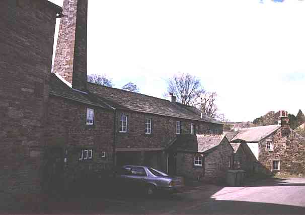 the confluence
of the Caldew and Caldbeck rivulet, 1½ miles N.W. of Hesket New Market3,
and 7 miles S.S.E. of Wigton. Here is a woollen manufactory, said to be noted for
the manufacture of "self grey cloth," for top coats; a fulling mill; two
corn mills; and a brewery, &c. Mr. Denton4 describes
Caldbeck as being "a dale lying being Warnell Fell and the mountains, Carrick5 and Grisdale Fells"; and as having taken its name from the
from the rill or beck, which rises between High Pike and Brae Fell, and "falleth down
eastward through the same into Caldey6, and therefore Caldy
beck, contractly Caldbeck; or of the coldness of the place, which is for the
most part in winter covered with snow, and therefore called Coldbeck, which, in the
dialect of the country is Caldbeck; the brook being fed by at least an hundred cold
springs flowing into it from these mountains." The Church, which is
the confluence
of the Caldew and Caldbeck rivulet, 1½ miles N.W. of Hesket New Market3,
and 7 miles S.S.E. of Wigton. Here is a woollen manufactory, said to be noted for
the manufacture of "self grey cloth," for top coats; a fulling mill; two
corn mills; and a brewery, &c. Mr. Denton4 describes
Caldbeck as being "a dale lying being Warnell Fell and the mountains, Carrick5 and Grisdale Fells"; and as having taken its name from the
from the rill or beck, which rises between High Pike and Brae Fell, and "falleth down
eastward through the same into Caldey6, and therefore Caldy
beck, contractly Caldbeck; or of the coldness of the place, which is for the
most part in winter covered with snow, and therefore called Coldbeck, which, in the
dialect of the country is Caldbeck; the brook being fed by at least an hundred cold
springs flowing into it from these mountains." The Church, which is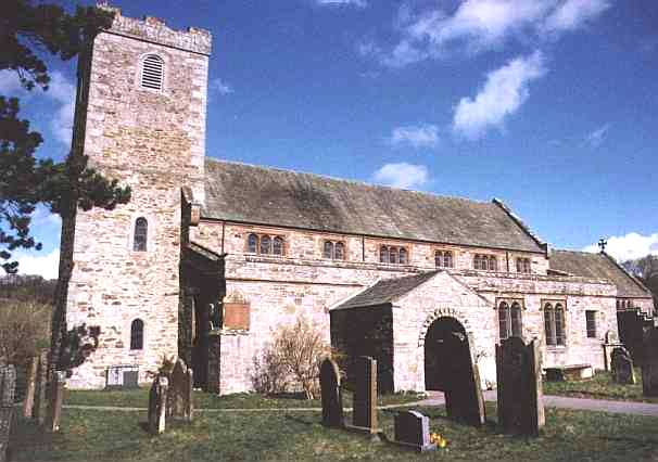 dedicated to St. Mungo, or Kentigern7
- the tutular8 saint of the north - is situate in the village,
and is a very ancient fabric; supposed, from a date which it bears, to have been erected
in the year 1112. The benefice is a rectory, valued in the king's books at £45 13s. 6d.,
and returned, in 1835, as of the annual value £436. The bishop of Carlisle is the patron,
and the Rev. James Lynn, M.A., is the rector, for whom the Rev. Christopher Parker
officiates as curate. Long after the conquest, this parish was a wild forest and desolate
waste, and, being crossed by a high road, which extended from Westmorland to the western
coasts of Cumberland, it lay under the imputation of being the resort of banditti and
dangerous outlaws, who frequently assailed travellers. To prevent this as much as
possible, Ranulph Engain, the chief forester of Englewood9,
granted a license to the prior of Carlisle to build an hospital here, for the purpose of
entertaining travellers and protecting such as were benighted from the hands of prowling
freebooters. On this grant, the prior enclosed some portion of the forest in the environs
of the hospital, where soon afterwards was erected the parish church, which, as usual, was
in a short time surrounded by a village. The hospital was dissolved about the time of king
John, and the church endowed with its lands; which lands "have since been called the
manor of Kirkland."
dedicated to St. Mungo, or Kentigern7
- the tutular8 saint of the north - is situate in the village,
and is a very ancient fabric; supposed, from a date which it bears, to have been erected
in the year 1112. The benefice is a rectory, valued in the king's books at £45 13s. 6d.,
and returned, in 1835, as of the annual value £436. The bishop of Carlisle is the patron,
and the Rev. James Lynn, M.A., is the rector, for whom the Rev. Christopher Parker
officiates as curate. Long after the conquest, this parish was a wild forest and desolate
waste, and, being crossed by a high road, which extended from Westmorland to the western
coasts of Cumberland, it lay under the imputation of being the resort of banditti and
dangerous outlaws, who frequently assailed travellers. To prevent this as much as
possible, Ranulph Engain, the chief forester of Englewood9,
granted a license to the prior of Carlisle to build an hospital here, for the purpose of
entertaining travellers and protecting such as were benighted from the hands of prowling
freebooters. On this grant, the prior enclosed some portion of the forest in the environs
of the hospital, where soon afterwards was erected the parish church, which, as usual, was
in a short time surrounded by a village. The hospital was dissolved about the time of king
John, and the church endowed with its lands; which lands "have since been called the
manor of Kirkland."
The manor of Caldbeck is divided into two divisions, called Caldbeck Upperton, or Upton (being that part which lay near the church), and Caldbeck under Fell, the part near the mountains. It was a parcel of the great barony of Allerdale, until the heiress of the Lucy family carried it, in marriage, to the Percys, earls of Northumberland; with whom it remained till the sixth earl gave it to Henry VIII, who sold it to Thomas Dalston, Esq., and Thomas, lord Wharton; the latter of whom subsequently purchased Mr. Dalston's moiety. The whole continued in the Wharton family till the famous duke Philip - whom Pope calls "the scorn and wonder of our days," and who was the last of the family - was obliged to alienate this and other great estates to four trustees, for the payment of his debts. It was re-sold to Charles, duke of Somerset, from whom it passed to the earl of Egremont, so that general Wyndham is now lord of the soil; but the minerals, which had been reserved by the crown, now belong to the earl of Pomfret, Sir George William Denys, Bart., and Sir Frances Shuckburgh, Bart. Hutchinson, who wrote in 1794, says, "the earl of Egremont has no demesne lands here, but several free rents, and about 120 customary tenants, who pay £49 16s. 3d. yearly rent, a tenpenny fine certain; with heriots, suit of court, and the thirteenth moulter."
Brown Rigg10 and Ratten Row are two hamlets in Low Caldbeck township, at the latter of which the rector has a little manor, the tenants whereof, says Hutchinson, "pay £7 17s. 4d. customary fines, and, on alienation, an arbitrary fine, but on the change of a tenant, by death, only a God's penny; and on the death of the lord, nothing." There was here, for many years, a coal mine and slate quarry.
Caldbeck Fells - Lead and Copper Mines, &c. - "Caldbeck Fells, including the lofty mountains of Carrock, High Pike, Brae Fell, Cald Fell, Noon Fell11, and several smaller eminences, form an extensive alpine region, comprising the greater part of this parish, and composed chiefly of sienite, incumbent upon granite, which forms the beds of the Brandy Gill, and some other smaller rivulets in this neighbourhood." Here are numerous veins of lead and copper ore12; the former, found about fifty yards below the surface, in Driggeth vein, is said to have "produced 50 per cent in lead, and 60 ounces of silver to a ton of lead." About the year 1790, a Mr. Row opened this rich mine, and wrought it, by shallow shafts, day levels, and a kind of water engine, to the depth of 20 or 25 fathoms; and he also erected, on the old principle, Little Smelting Works, near Carrock Beck, which are still remaining. Having remained idle for several years, the mine was leased and re-opened, in 1810, by Messrs. Richardson, Lowrey, and others, who, shortly after, built a crushing mill, to reduce the ore to a proper size for dressing. The working was continued by this company, till about 1823, during which time they employed from 30 to 40 pickmen, who raised yearly about 500 bings of ore, every bing of which yielded one fother of lead, and from 45 to 50 (and in some instances 62) ounces of silver. T.R. Braddyll, Esq., of Conishead Priory, next purchased this mine, and drove up a still deeper level by 30 fathoms, at considerable expense, but it proved a losing speculation. About the same time, a company of working miners and others took up Roughton Gill and Silver Gill mines, which had been unnoticed; but, after a struggle of eight years, a deeper level became necessary to win the mines, and the company were obliged to sell their shares to others who possessed more capital. The late Thomas Dickinson, Esq., of Alston, who purchased one-fourth of the mine, having taken an active part in forwarding the work, a level, 30 fathoms deeper, was effected, to the extent of 300 fathoms; and a crushing mill and other apparatus for washing the ores were constructed. During the seven years previous to 1845, when their term expired, no fewer than about 3229 tons of lead, and 150 tons of copper ores, were raised. The ore is still going deeper, and another level is expected to be commenced when the treaty for the mine is completed. About 70 tons of copper ore were raised at Carrock-end mine, from 1839 to 1842, by the Rev. Francis Thompson. In August, 1847, a new level was set on at Dry Gill mine, by the spirited lessee, Hugh Lee Pattinson, Esq., of Washington House, near Gateshead, chemical manufacturer, and patentee of a valuable improvement in the refinement of lead; who, since 1845, has raised upwards of 20 tons of the arsenia phosphate of lead. These ores have no where been found in such quantities as to have been subjected them to the usual process of smelting, which, however, has been proved to be defective in properly separating the lead or arsenic, so peculiarly combined in them. From the assay, they produce about 64 per cent, and one ounce of silver, or little more, in a ton of lead. Driggeth mine has been worked by various parties, with little (if any) profit, during the last ten years. The present lessees are the Messrs. Dickinson & Co. In Roughton Gill vein, while the produce, in lead, is 60, 65, 70, and even as high as 74, by assay, per cent, the produce of silver seldom exceeds 35 ounces per ton of lead. This and Silver Gill mine, which are said to have been opened in the 17th (or early in the 18th) century, have evidently been very productive, but the old workings show a want of mining skill. The mines are generally let, upon lease, for 21 years, at a stipulated duty - paid in ore in the raw state, or in smelted lead; and it is the opinion of practical men that if more liberal encouragement were given to the enterprising spirit of the present day, and the various improvements in mining introduced, this manor would yield an increase of royalty hitherto unattained, together with remunerating profits to the adventurer, and abundance of labour to the working miner; but it is to be doubted whether the old hacknied saying would even then be verified, that
"Caldbeck, and Caldbeck Fells
Are worth all England else."
Here are a great variety of minerals, useful only for the cabinets of the curious, viz., molybdena, wolfram13, &c.; and a vein at Brandy Gill contains the ores of tin, both of a resinous and nearly black colour, but the matrix of the vein is almost as hard as tempered steel. A loose specimen of lead ore was discovered on Nether-row-brow, and found to contain silver in the proportion of 600 oz. per ton; and, in 1815, there was an emerald found in the river Caldew.
The huge mountain, called Carrock Fell, lies wholly in
this parish. Its height is about 700 yards above the level of the sea, and about 520 above
the level of the fields immediately at its base. About a mile and a half by a mile of its
eastern side seems entirely covered with stones, and on its lofty summit are many heaps of
stones varying in supposed weight from 4 cwt. to 5 lbs, (the larger ones being more
general) and occupying an elliptical area, whose transverse diameter within the
surrounding piles of stones, is 252 yards, and conjugate diameter 122 yards, and the area
of the space thus enclosed is 4A. 3R. 38P. About half a mile west from the 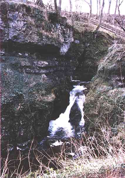 parish church, in a wild
and romantic situation, is a very striking natural curiosity, called the Howk, (a
term common in the north for scooping out earth,) which is a waterfall in a narrow gill,
or dell, at the bottom of which runs the river Caldew, over which a natural bridge14 of limestone rock is formed. Through the narrow arch of this
bridge the stream rushes with great impetuosity, and dashing along over other rocks,
empties itself into a large bason, which seems to boil in various whirling eddies, covered
with white foam. On one side of this bason, or pool, is a curious excavation, about six
yards in diameter, called the Fairy Kettle, scooped out nearly in the shape of a
huge cauldron, and as smooth inside as if polished by a statuary; and here is formed
another cascade between two perpendicular rocks, about twenty yards in height. A little to
the right is a cavern, 18 yards long, denominated the Fairy Kirk, in which the
roaring of the unseen cataract has an imposing effect. Not far from Carrock, at Halt
Close Bridge, the river Caldew takes a subterranean passage, which it keeps for a
space of about four miles, when it emerges opposite to Warnell Hall estate, near Sebergham
Bridge, at a place called the Spouts Dub. This subterranean course is formed almost
entirely of limestone rock; and, in dry summers, when the water is low, takes in nearly
the whole stream.
parish church, in a wild
and romantic situation, is a very striking natural curiosity, called the Howk, (a
term common in the north for scooping out earth,) which is a waterfall in a narrow gill,
or dell, at the bottom of which runs the river Caldew, over which a natural bridge14 of limestone rock is formed. Through the narrow arch of this
bridge the stream rushes with great impetuosity, and dashing along over other rocks,
empties itself into a large bason, which seems to boil in various whirling eddies, covered
with white foam. On one side of this bason, or pool, is a curious excavation, about six
yards in diameter, called the Fairy Kettle, scooped out nearly in the shape of a
huge cauldron, and as smooth inside as if polished by a statuary; and here is formed
another cascade between two perpendicular rocks, about twenty yards in height. A little to
the right is a cavern, 18 yards long, denominated the Fairy Kirk, in which the
roaring of the unseen cataract has an imposing effect. Not far from Carrock, at Halt
Close Bridge, the river Caldew takes a subterranean passage, which it keeps for a
space of about four miles, when it emerges opposite to Warnell Hall estate, near Sebergham
Bridge, at a place called the Spouts Dub. This subterranean course is formed almost
entirely of limestone rock; and, in dry summers, when the water is low, takes in nearly
the whole stream.
Caldbeck (High) contains the hamlets of Branthwaite, Fellside, Hudscales, Green-Rigg15, and Nether Row, with some scattered dwellings extending from one to three miles W., and W. by S. from Hesket Newmarket, being bounded on the south by Caldbeck Fells. Hudscales seems to have taken its name from the Saxon term hyde; and scales or skales formed also from the Saxon or Gothic word skalga (a cover) were huts built of peat for the shelter of the shepherds.
Caldbeck Haltcliff township contains the town of Hesket Newmarket, the hamlet of Haltcliff16, half-a-mile south, with the hamlets of Howbeck, Woodhall, and Mosedale. The latter is four miles S. of Hesket, and with Swineside, which lies opposite to it17, forms a mense manor, held of General Wyndham. Hutchinson says that this manor was the place where the Dacres, Barons of Greystoke, formerly kept their deer and wild swine, that when the country became more populous it was divided into tenancies, and that each tenant paid 14s. yearly to Mr. Hasell. George Fox, the founder of the Society of Friends, resided for some time at Woodhall.
Hesket New Market is a small market town, at the southern extremity of the parish, on the west side of the river Caldew, one mile S.E. of the parish church, seven miles E. of Ireby, and eight miles S.E. of Wigton. Its name is supposed to be a corruption, arising out of the rapid pronunciation of East Cote, or East Gate; both this and Hesket in the Forest having, perhaps, formerly, been the eastern inlets into the forest, on which they respectively joined18. The market, which was held on Friday, is nearly obsolete, or at least of little consequence; but cattle fairs are held here on the first Friday in May, and every alternate Friday till Whitsuntide; and for sheep and cattle, on the last Thursday in August, and the second Thursday in October. Hesket Hall, now a farm house, "is a curious old building." Howbeck forms the southern suburb of Hesket, and here is a school, to which Richard Richardson has left £3 a year, to be paid out of his estate at Wham, for the education of three poor children of Caldbeck parish.
Mannix & Whellan, History, Gazetteer and Directory of Cumberland, 1847