CHAP. VIII
Route to Cockermouth, Harrington, 8c.
About a mile higher up the river, Cammerton Hall, the seat of Mr. Cooke, an old but good
building, is pleasantly situated on the north side of the Derwent. From hence to
Cockermouth the vale becomes rich and fertile, and is generally well-cultivated.
 COCKERMOUTH is a market-town
standing at the mouth of the river Cocker, where it enters the Derwent, and contains about
2600 inhabitants. The grounds on each side are high and undulating, with some small
patches of wood on their fronts; but much of those on the south side are green,
uncultivated commons. The vale of Derwent is beautiful, expanding in fine rich holmes. -
The streets of Cockermouth are spacious, and pretty clean. Here are two principal streets
in an angular figure from the bend of which a short one leads to the castle. - The church
and castle are two bold figures in the general appearance of Cockermouth: but the latter
is now in ruins, except some apartments at the gate. It stands on a fine eminence at the
confluence of the rivers Cocker and Derwent, and has been a fortress of considerable
extent and strength. The tower is lofty, and commands an extensive prospect. In exploring
these massy remains, we observe, on each side of the gateway leading to the interior
court, a dungeon capable of containing 40 or 50 persons each. A small aperture has been
left in the crown of the arch, to let down the unhappy wretches who were doomed to the
horrid cell; on the side of each is a slip, or loop hole, whereby the provisions were
conveyed with a rope to the miserable captives. Such severities as these, which the
prisoners of war suffered in ancient times, certainly rendered their battles more
desperate and bloody. This Castle was the Baronial seat of the Lords of Allerdale, and is
supposed to have been built a few years after the Conquest. In the year 1648, being
garrisoned by the King, it was reduced by the Parliamentary forces, burnt, or otherwise
dismantled, and has laid in ruins ever since. The Earl of Egremont holds his courts of audit
in the castle, where he has some apartments fitted up; and he resided here for a short
time, last summer.
COCKERMOUTH is a market-town
standing at the mouth of the river Cocker, where it enters the Derwent, and contains about
2600 inhabitants. The grounds on each side are high and undulating, with some small
patches of wood on their fronts; but much of those on the south side are green,
uncultivated commons. The vale of Derwent is beautiful, expanding in fine rich holmes. -
The streets of Cockermouth are spacious, and pretty clean. Here are two principal streets
in an angular figure from the bend of which a short one leads to the castle. - The church
and castle are two bold figures in the general appearance of Cockermouth: but the latter
is now in ruins, except some apartments at the gate. It stands on a fine eminence at the
confluence of the rivers Cocker and Derwent, and has been a fortress of considerable
extent and strength. The tower is lofty, and commands an extensive prospect. In exploring
these massy remains, we observe, on each side of the gateway leading to the interior
court, a dungeon capable of containing 40 or 50 persons each. A small aperture has been
left in the crown of the arch, to let down the unhappy wretches who were doomed to the
horrid cell; on the side of each is a slip, or loop hole, whereby the provisions were
conveyed with a rope to the miserable captives. Such severities as these, which the
prisoners of war suffered in ancient times, certainly rendered their battles more
desperate and bloody. This Castle was the Baronial seat of the Lords of Allerdale, and is
supposed to have been built a few years after the Conquest. In the year 1648, being
garrisoned by the King, it was reduced by the Parliamentary forces, burnt, or otherwise
dismantled, and has laid in ruins ever since. The Earl of Egremont holds his courts of audit
in the castle, where he has some apartments fitted up; and he resided here for a short
time, last summer.
The only late improvements made in this town worthy of notice is a handsome range of buildings, on the banks of the Cocker, a little above the bridge, the property of Messrs. Stoddart and Son, where an extensive linen manufactory is carried on. There is also a large thread and cotton-manufactory called the Goat Mills, the property of, and carried on by, Mr. Wm. Fletcher. There is also an extensive manufactory of hats, and another of coarse woollen cloths and shaloons; likewise a pretty considerable trade in tanning and dressing of leather. About a mile up the Cocker is a paper-mill carried on by Mr. Harden.
This is a very ancient borough, and sends two members to Parliament. The first we meet with was in the 2d Edward I.: it discontinued the franchise for several centuries; and the next returns we find to be in the year 1640. The election is by the inhabitants having burgage tenure, who are about 300; and the Bailiff of the borough is the returning officer. He is chosen annually at Michaelmas out of the burgesses, by the jury of the leet, which is composed of burgesses, and forms a special jury for the government of the borough. He is head officer within the town, and executes the duty of clerk of the market.
In the town is a free school, and a parochial library, containing about 500 choice volumes.
PAPCASTLE, on the northern banks of the Derwent, at a little distance from Cockermouth, is one of the finest villages in the county. - Adjoining this village are the ruins of a large Roman Castrum, supposed, by Dr. Stukely, to have been called Derventio, derived from Derwent.
From Workington to Harrington is two miles and a half. The road leads us along a naked shore, well stocked with rabbits.
HARRINGTON is a small port or creek, containing about 1000 inhabitants. The harbour has been recently much improved. It stands low, close to the shore, at the mouth of a small brook, and is surrounded with high, naked grounds on every side. Nearly 60 vessels, of 100 tons burden each upon an average, belong to this little port; which are chiefly employed in exporting lime and coal to Ireland and Scotland. The vessels come quite into the town, and anchor very conveniently and snugly before the houses. - The ground on which the town is built, as well as that which surrounds it, is the property of J. C. Curwen, Esq. - The church is an ancient, but neat edifice; and there is a handsome house for the incumbent; the former has recently been much enlarged, and a considerable portion of it left unappropriated. - This place is very flourishing, and amongst a number of buildings which are erecting, we must not omit to mention a new school-house, under the patronage of J. C. Curwen, Esq. for the instruction of children on the same plan as the Workington school. There are also here two yards for ship-building. - The old part of Harrington consists of a few small farms straggling up the dell; and a little village, well built, and pleasantly seated on the top of the bank. - Beside the coal and lime got in this neighbourhood, ironstone, of excellent quality, is got above the seams of coal; of which 2000 tons are annually exported to various works in Scotland and Wales. Iron-clay is also obtained, in large quantities, of which about 500 tons are annually shipped. There is also here a copperas1 work carried on by Mr. R. Dalton, of Liverpool.
We continue our route from Harrington to Whitehaven, about five miles. - The road leads from the shore, over a naked and barren district. The large village of Dissington2 appears in an exposed situation, on the left; near which there are a number of lime kilns, where a large quantity of lime is burned, and shipped off to Scotland. The country, for many miles to the south and east, is rather wild and unpleasing. A considerable part, however, of the parishes of Dean, Arlechden3, and Lamplugh, in these quarters, is pleasant, and tolerably fertile; the soil is various, but generally dry and productive; the surface not hilly, but irregular, and mostly ornamented with straggling trees, and good hedge-rows.
We next reach MORESBY, a small, but pleasantly situated village. Here was the Roman station of Arbeia.- (See page 42, Part 1.) - The ruins are very conspicuous, and, from the site, there is a very fine view of the sea, to which the bank from hence descends rapidly. The church of Moresby is seated within the limits of this station. - Just below, at a little distance, stands the small, well-built village of Parton, close to the sea. It has a good quay and harbour, where formerly many coals were shipped, but the trade is now almost wholly centered in Whitehaven and Harrington.
From Moresby, the road leads along the side of a naked bank, having a fine sea view, but with an unpleasant country on the other hand, blackened with coal, and smoking with steam-engines, till, suddenly, the large, populous, regular, and well-built town of Whitehaven appears just below us, in a crook, nearly hemmed in by steep hills. The town stands low, on pretty level ground, and can hardly be seen from any direction, till a person be close upon it. We descend Bransty-brow, on the top of which stand two tall pipes of stone, called the Tobacco Pipes, which were erected there to burn the condemned tobacco seized by the custom-house officers.
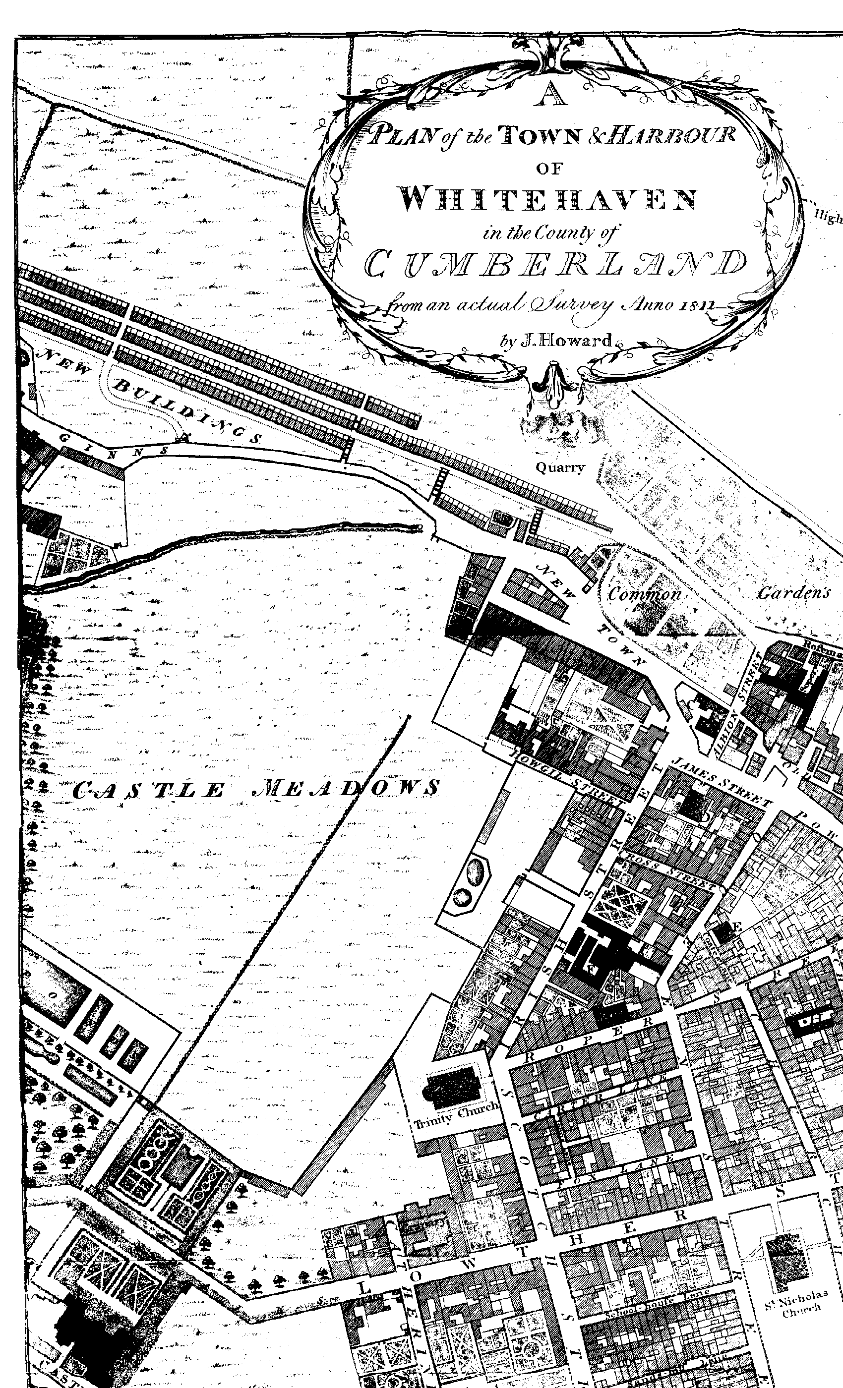
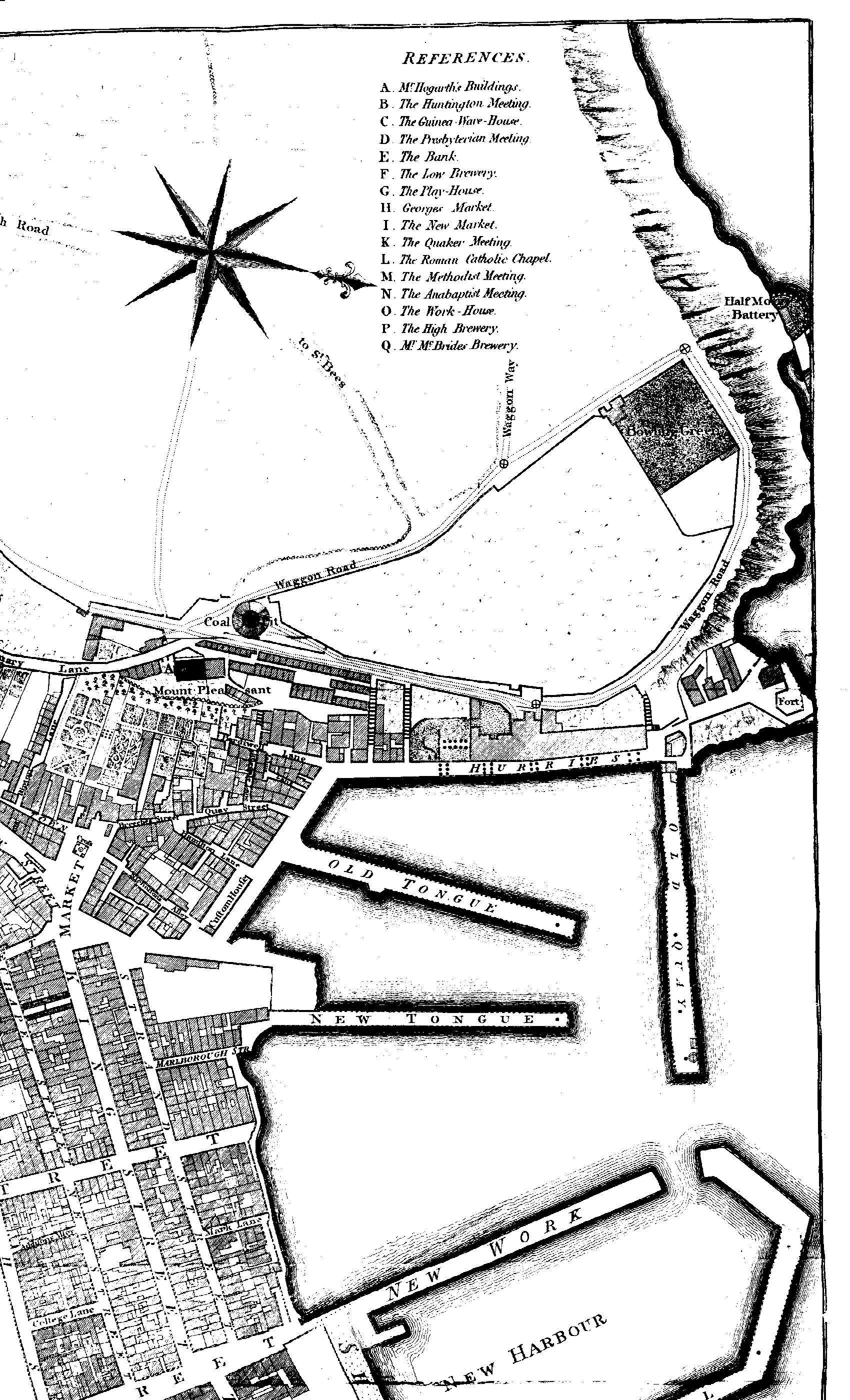
WHITEHAVEN is the property of Lord Lonsdale; by the exertions of whose family it has risen, within the last 170 years, from a few huts, to a wealthy and flourishing town, which now occupies a distinguished station in the commercial world, and boasts of upwards of 16,000 inhabitants. The name of Whitehaven is thought by some to have originated from the grey rock, called Tom Hurd Rock: but others, with more plausability, affirm, from some old accounts handed down, that a person, whose name was White, the first fisherman who frequented this bay, and who lived at Land wath, about two miles from Whitehaven, built a cottage in that part now called the Old Town, to shelter himself, which thence took the name of White's Haven. In confirmation of this supposition, Whitehaven is generally called by many old people in the neighbourhood, Whitton, that is, White's Town. - In the survey taken in 1566, Whitehaven consisted only of six fishermen's cabins, and one small bark, about nine tons burden - sufficient to supply the religious society of St. Bees with fish, salt, and other articles of their diet. In 1633, there were no more than nine or ten thatched colleges. Sir John Lowther, soon after conceiving the project of working the coal-mines, and improving the commerce of this county, obtained from King Charles II. in 1666, a grant of all the ungranted lands within this district; and in 1678, he obtained all the lands, for two miles northward, between high and low water mark. From this period we may date the commencement of Whitehaven's flourishing state. In 1693, the families in this town had increased to 450, which consisted of 2272 inhabitants; and in twenty-two years more, there were no fewer than 800 families, which have been progressively augmenting to the present time.
The increase of shipping, trade, and commerce, kept pace with that of population. It appears that in 1685, 46 vessels, exclusive of boats, belonged to the port of Whitehaven: the total burden of these ships was then 1871 tons. In 1772, there were 197 vessels belonging to Whitehaven, 5 to Parton, 97 to Workington, 76 to Maryport, and 12 to Harrington, according to a printed list then published, which, however did not notice the tonnage. By another list, dated 20th May, 1790, it is stated, that 216 ships belonged to Whitehaven, 116 to Workington, 87 to Maryport, and 26 to Harrington; in all 445, besides 15 on the stocks at the different ports. This wonderful increase of shipping, belonging to the coasts of Cumberland, has been made in little more than 200 years. - The exportation of coals to Ireland is the great source of the support and wealth of Whitehaven; but its trade is now extended to Africa, America, the West lndies, and almost every commercial town in Europe.
The approach from the north is by a fine portico of red freestone, with a rich entablature, ornamented with the arms of the family of Lowther. This edifice is not constructed for mere shew, but for the purpose of continuing the course of a gallery, by which the waggons, laden with coals, are designed to pass to the haven, where they may deliver their contents into the ships.
On the south of the town is a fine new road, made last year, of about a mile in length, not inferior to any in England. Half this road is arched over, and a brook runs underneath.
At the south-east end of the town, on an easy rising ground, there is a most noble mansion of the Earl of Lonsdale, called the Flat, and by some the Castle.
A dispensary, instituted here about 25 or 26 years ago, is well supported by the humane and charitable inhabitants of Whitehaven, as well as the noblemen, and gentlemen in its vicinity.
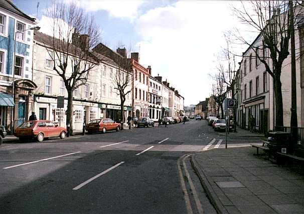
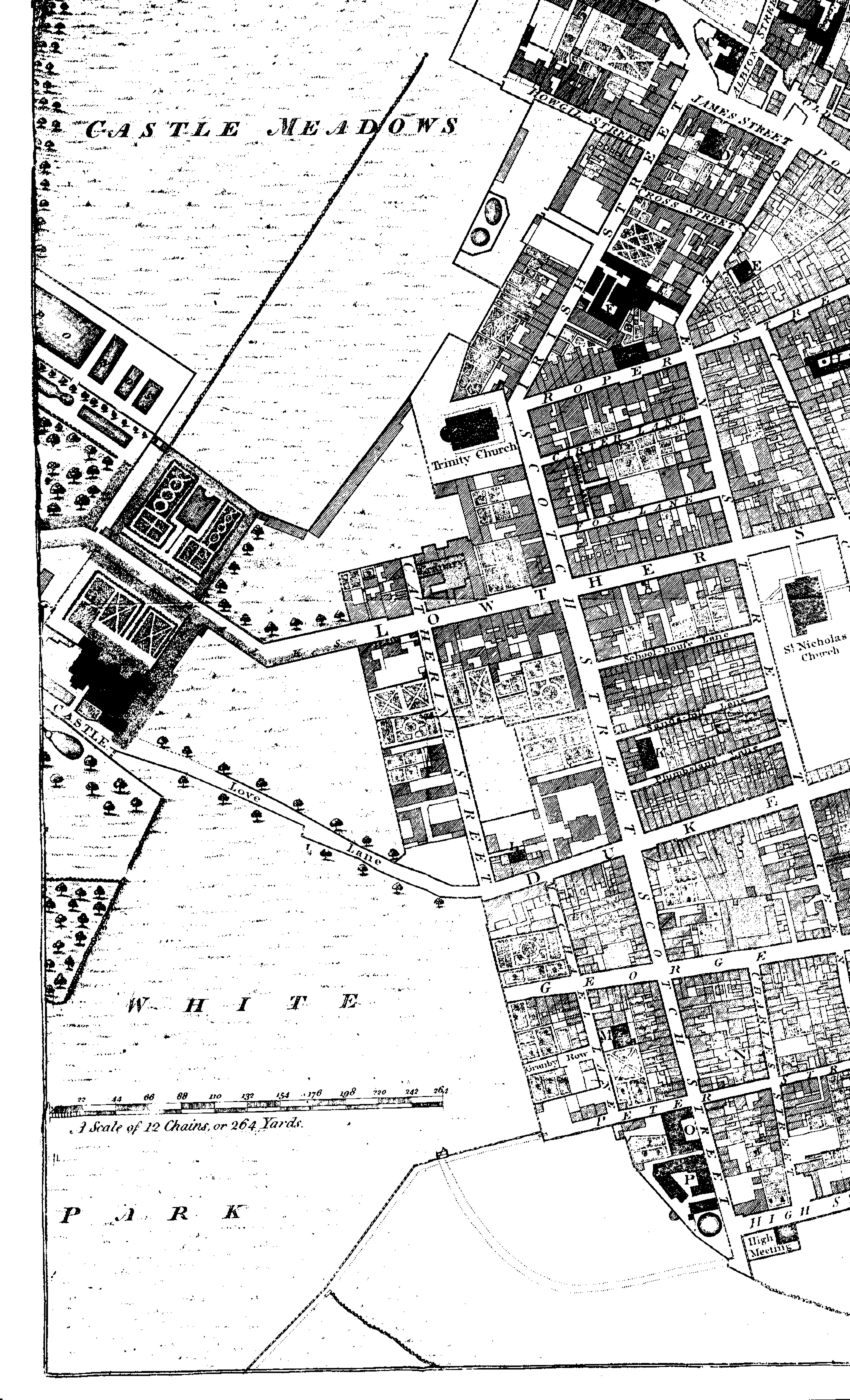
The town of Whitehaven is built on a regular plan; the streets are generally spacious and clean, and cut each other at right angles. Buildings are neat, and many of them genteel: the shops exhibit a degree of elegance not often met with in the north: the houses are in general covered with blue slate, which gives the town a beautiful appearance from the adjoining heights. A narrow vale, the bottom of which is completely filled by the town, extends to the village of St. Bees, about five miles distant, nearly upon a level, and is generally supposed to have been formerly occupied by the sea; this opinion is partly corroborated, not only by the appearance of the soil, but also by the discovery of a ship's anchor at a considerable depth in the ground, about half way up the vale. The whole valley might be cut through, so as to make it navigable for large vessels, at a moderate expence; which would often prove convenient to ships aiming at the port of Whitehaven, when certain winds render the passing round St. Bees' Head extremely dangerous. - The small rivulet Poe meanders along this vale from St. Bees, and empties itself at Whitehaven; over which an arched vault was thrown in 1764, by which the market place was greatly enlarged, and rendered much more commodious. - Water pumps are now put up, for the benefit of the public, which supply the town much better than formerly.
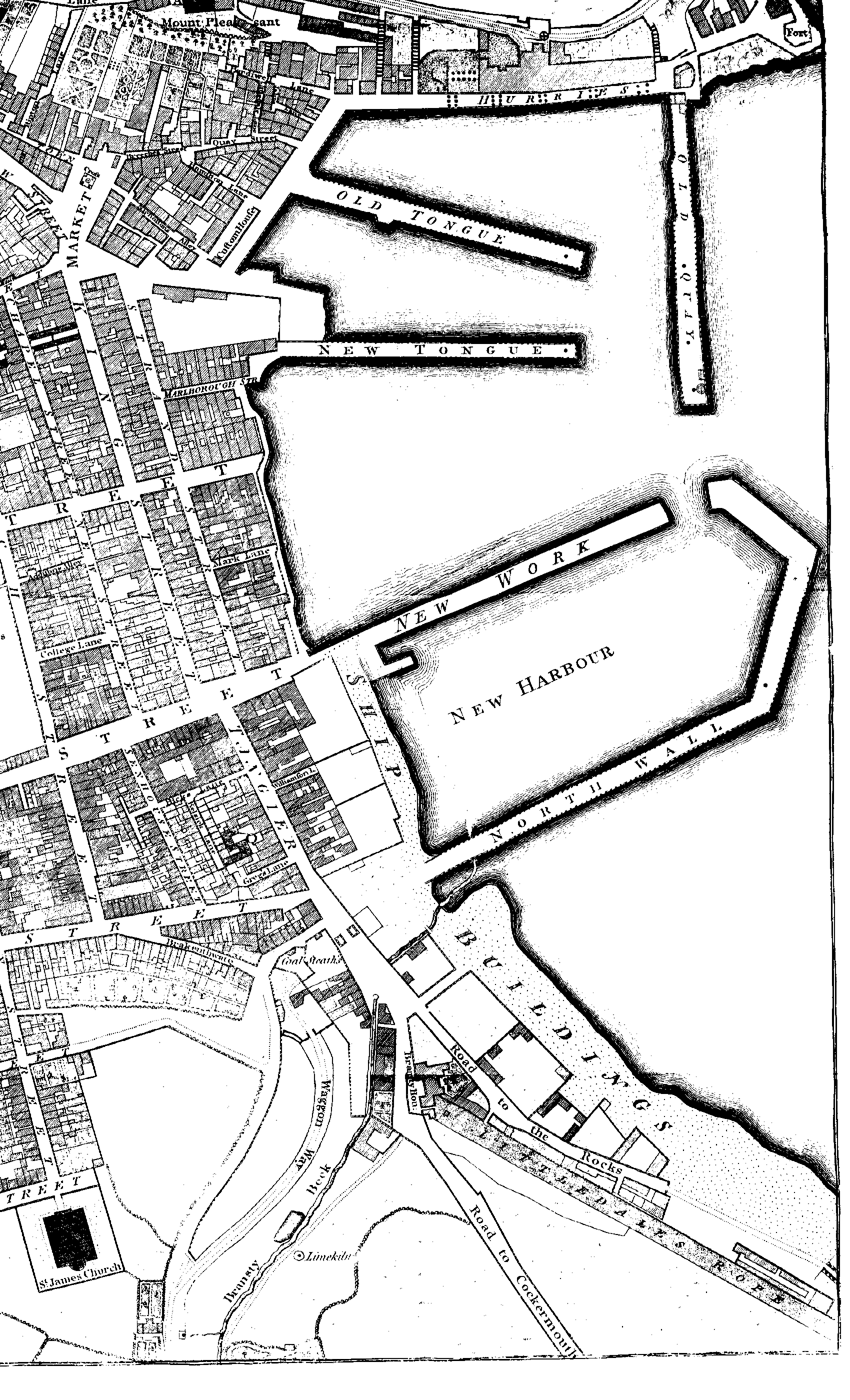
The piers, or moles of the harbour, have been greatly enlarged and improved within these few years: They are - 1st, The Breast Work and Old Quay - 2d, The Old Tongue - 3d, The New Tongue - 4th, The New Quay - 5th, The New Work - 6th, The North Wall - The New Work (formerly called the Bulwark) has been entirely rebuilt on a larger plan; and to the extremity of the Old Wall several yards have been added - which approach toward the New Work, and by narrowing the entrance into this part of the harbour, was intended to preserve the place from swells of the sea, to which it was much exposed. A considerable length has been also added to the Old Quay. Besides these improvements, foundations were laid down in 1809 for further altering the harbour, but not yet built upon. - The reader will form a clear idea of Whitehaven by referring to the very accurate accompanying map4, from actual servey by Mr. John Howard.
A very large and commodious poor-house was built here in the year 1743; and in 1795, the town of Whitehaven was incorporated, as to all concerns relative to the poor, under an amended Act of Parliament.
Here are three public breweries, one at Corkickle, a quarter of a mile distant, on the Egremont road, and one at Parton, near Morresby. - Whitehaven also contains six yards for ship-building; and it is not unusual to see 12 or 16 new vessels upon the stocks at the same time. The vessels built at Whitehaven seem, to have obtained considerable repute for strength, burden, and a small draught of water. - A sail-cloth manufactory of considerable extent, and three large roperies, have also been established here.
A very handsome theatre on a plan copied from that of the Bath theatre, was built here by subscription, in 1769. - Public lamps were put up in Whitehaven in 1781. - Three banks have been opened here; one in 1786, another in 1793, and a third in 1807.
The only packet-boat employed by Government between Great Britain and the Isle of Man, sails from Whitehaven and Douglas weekly. It was established in 1766.
Whitehaven is defended by four batteries, mounting in all 98 cannon, among which are 12 forty-two pounders, and 18 of thirty-six. These batteries command the whole bay, and the coast towards Harrington and Workington: they were repaired, and an additional number of guns procured from Woolwich in 1788, owing, it is said, to the alarm occasioned by the landing of Paul Jones, who came on shore here on the 23d of April in that year.
The coal-works, being near the sea, are very convenient for shipping; some of these mines are wrought many hundred yards under the sea, and others beneath the town. This latter circumstance, in its consequence, occasioned great alarm to the inhabitants some years ago which is thus recorded in the History of Cumberland, taken from the provincial newspaper of Whitehaven.
"About two o'clock, on Monday the 31st of January, 1791, in the afternoon, the ground suddenly shrunk in the garden of H. Littledale, Esq. behind his house, in Dukes-street, and the noise of subterranean waters was heard on the spot, by a servant there at work. - Near the same time, the ground sunk is a garden behind the house once occupied for the Dispensary, in Scotch-street, and in the burial-ground behind the Baptist meeting-house, in Charles-street, all on the north side of the town.
"This event created much alarm, as it was evident it proceeded from the falling in of some of the old coal-works; and it afterwards appeared, that a great discharge of water had flowed in upon the working pits, and two men and a woman, with five horses, were drowned in the works.
On Wednesday evening, another plot of ground sunk, within a few yards of the former settling, in Mr. Littledale's garden; and other sinkings, though much more trivial, were observed in different places. - This accident was attributed to a workman in a new drift unfortunately striking into a drowned waste, or old working. Several workmen and horses were saved from the fate of the others, by remaining in their workings till the water ran of, which was in about two hours after its old lodgment had been pierced.
"The number of houses which were, in a manner, demolished by those sinkings, amounted to 18, among which was Mr. Littledale's elegant mansion; - and between 60 and 80 families deserted that part of the town. - The furniture was saved out of all the houses, except two. - The pavement in George-street was rent in many places.
"Skilful coal-viewers were immediately employed to inspect all the old workings which were accessible, and their report, that no further danger was to be apprehended, quieted the minds of the inhabitants, and brought them back to those deserted dwellings which were not shook by the alarming accident. - No further calamity has ensued."
Mr. Littledale's house is now repaired, and is the public office of the Earl of Lonsdale - the Town or County Court is held here.
Coal, it is supposed, was first raised here about 150 or 160 years ago; and since which time the workings have increased rapidly. It is conjectured, that, at present, about 80,000 waggons of coals are annually raised in these collieries; each waggon being equal to a chaldron and one quarter, London measure: containing 24 Cumberland bushels, or 72 Winchester bushels, and weighing, in general, from 42 to 44 hundred weight. Here are coal-pits 320 yards deep, which are supposed to be the deepest coal-mines in the world. As they extend to a great distance under the sea, ships of large burden sail over where the miners are at work. Some very powerful fire-engines have been erected to draw off the water; one of which has two boilers of 15 feet diameter each, a 70 inch cylinder, and 11½ inches working barrel. Its maximum in working is 15 strokes, each 6½ feet long, in a minute. Twenty-seven gallons of water are drawn by each stroke, which is 405 gallons per minute, or 9240 hogsheads in 24 hours.
The coals are brought to the harbour in waggons, along a railed-way of an easy descent, and are carried by their own weight, with about two tons of coals in each. They are thus conveyed, on the same declining level, till they are brought above the vessels, and then at once projected down hurries into the ships. The coal-staith is on the west side of the town, adjoining the harbour, where five vessels of 300 tons burden are frequently loaden from the hurries at the same time.
From Whitehaven we proceed to Egremont, five miles and three quarters. The road conducts us past Hensingham and Hollins; the former the seat of Thos. James, Esq. and the other that of James Bell, Esq. On the left from Whitehaven to Egremont, about four miles distant, is Linethwaite, the seat of Thos. Hartley, Esq. and distant three miles, Springfield, the seat of Samuel Potter, Esq. - On the right, the ancient village of St. Bees stands in a contracted vale, near the sea. From the noted free-school there many excellent scholars have been sent to the University and other places. Here is also the ruins of an ancient priory, said by Tanner to have been founded about the year 650, by Bega, an holy woman from Ireland. This religions house being destroyed by the Danes, was restored by William, son to Ranulph de Meschines, Earl of Cumberland, and made a cell for a Prior and six Benedictine Monks. The east limb of the church, which is now unroofed and in ruins, shews but few marks of its former elegance, except where the communion-table was placed. The whole edifice forms a cross: the nave is used as the parish church, and the cross aile as a burial place.
On the other hand we skirt the parish of Cleator, which, although it does not discover many outwardly enticing traits, is rich in coal, limestone, and more particularly in iron-ore.
The coast from Whitehaven is rocky, and rises abruptly from the sea, making a fine sweep into the ocean, to St. Bees, and afterwards runs tamely forward in almost a direct line. - Between Whitehaven and St. Bees, the banks along the shore rise into a lofty promontory, called St. Bee's Head, which is a conspicuous land-mark for sailors, with a light-house thereon. From this eminence there is a sea-view seldom equalled, and surpassed by none in the kingdom: the line of shore is distinctly seen to a great distance on each hand, with most of its creeks, bays, harbours, and ports; the Isle of Man, and the Scotch coast far to the west, are likewise clearly distinguished.
EGREMONT stands on one side of the vale of the river Ehen. It is a small and ancient market-town, consisting chiefly of one long and spacious street, which seems to be kept tolerably clean. Many of the houses have an antiquated appearance, though there are several genteel modern buildings. The vale appears somewhat naked; the surrounding grounds, however, though irregular in surface, are generally fertile. This town is about two miles from the sea on the one side, and a mile and a half from the pretty verdant mountain, called Dent, on the other; and, upon the whole, its situation is pleasant.
In the middle of the precipices forming St. Bees' Head, is a small bay, called Fleswick, very much resorted to in the Summer time by tea parties, who carry with them their utensils, and make fires in the caves of the rocks. - Of these caves there are several, but the path to and from the beach is difficult of ascent and descent. - It has a fine pebble beach of about 600 yards, and often, after a strong surf from the south-west, are found large transparent pebbles of variegated and different hues, not inferior to what is termed the Scotch pebble.
Egremont, Mr. Hutchinson observes, was an ancient borough, disfranchised at its own petition, as it is said, to avoid the expence of representation in Parliament.
On the west side of the town are the ruins of an old castle, standing on a little eminence, which was built by William de Meschines, brother to Ranulph de Meschines, a follower of William the Conqueror. This fortress, though not of great extent, bears evident marks of strength and antiquity. Mr. Hutchinson supposes it at least coeval with the entry of the Normans into Britain. The mount, he also says, is artificial, and in height 78 perpendicular feet above the ditch which surrounds the whole fortress, and which, he conjectures, has been a Danish fort.
We continue our route from Egremont to Ravenglass, 12 miles. At about two miles distance on the right, a straight line of flat shore runs parallel to the road. The intervening country presents nothing very striking to the eye: it is scattered over with villages, and farm-houses; the surface is tolerably level, or gently inclining towards the sea; and, from a general want of trees, is much exposed to cold blasts from the ocean. Some pleasant spots, however, are to be met with, particularly about the borders of the rivers Ehen and Calder. On the eastern side the country rises rapidly towards the mountains, which are from one to two miles distant. These are the frontier hills of that large collection of mountains which involve Keswick and the Cumberland lakes, and which from hence appear bleak, lumpish, and unpleasing,
Leaving Egremont, we soon pass Catgill-hall, the residence of Richard Wordsworth, Esq. Solicitor, on the right, over the river Ehen. On the opposite side, Hale-hall, the seat of Miles Ponsonby, Esq. rests on the feet of the mountains, in a rather high and exposed situation: it is, notwithstanding, a commodious mansion, and well situated for a sporting seat.
Entering the sweetly wooded vale of the Calder, we reach Calder Abbey, at about a mile up the valley on the left; and see Ponsonby-hall on its southern banks, a little below us on the right. Calder Abbey was founded in 1134, for Cistercian Monks, by Ranulph de Meschines, son of the first of that name. It stands in a deep, secluded vale, the sides of which are adorned with hanging woods, and bottomed with some fertile fields. The ruins of this religious house are fine, and singularly striking: they were carefully preserved by the late owner, J. T. Senhouse, Esq. whose very elegant mansion adjoins these venerable remains.
Ponsonby-hall, late the seat of George Ed. Stanley, Esq. stands on an excellent situation, commanding a delightful view of the beautiful vale below, and an extensive prospect over the sea, reaching to the Isle of Man, the Welch mountains, &c. This pleasant seat was built a few years ago in a genteel style, and the adjacent grounds and banks much improved. Mr. Stanley has planted upwards of 10,000 forest trees on the estate here, within the last twenty-six years. These plantations are in a thriving condition, and are now adding greatly to the beauty of the surrounding country, which already has a cheerful, pleasant aspect. The buildings in this district are generally good; and the soil, which is chiefly a red, hazel mould, is greatly improved. - At Calder-bridge there are two commodious inns.
 On the banks of the river Irt stands
Holme-Rook, lately the seat of Henry Lutwidge, Esq. but now the property of George Blake,
jun. Esq. with much modern improvement in its vicinity; consisting of plantations, good
gardens, and extensive pleasure grounds. - About a mile further up the river is seated
Irton-hall, the mansion of the ancient family of Irton; now the property of E. L. Irton,
Esq. A few old trees contribute to beautify the place. - The lofty mountain Screes, which
bounds the south side of Wast-water lake, runs in a long ridge to about a mile from
Irton-hall.
On the banks of the river Irt stands
Holme-Rook, lately the seat of Henry Lutwidge, Esq. but now the property of George Blake,
jun. Esq. with much modern improvement in its vicinity; consisting of plantations, good
gardens, and extensive pleasure grounds. - About a mile further up the river is seated
Irton-hall, the mansion of the ancient family of Irton; now the property of E. L. Irton,
Esq. A few old trees contribute to beautify the place. - The lofty mountain Screes, which
bounds the south side of Wast-water lake, runs in a long ridge to about a mile from
Irton-hall.
We approach Ravenglass; to reach which, a person must attend in the time of ebb tide, in order to ford the little river Mite, otherwise he will be obliged to go considerably further up before he can cross it.
RAVENGLASS is an ancient, but very small market-town, and a seaport, containing a few neat tenements, and a good inn for the accommodation of travellers. It stands at the confluence of the rivers Esk, Mite,and Irt, and about a mile from the general line of sea shore. The ocean forms a creek running up to the town; and also meets the fresh water in each river at some distance above it. Notwithstanding these advantages, Ravenglass is so situated as to enjoy little or no trade, the adjacent country furnishing little for exportation. The oysters, however, on this coast are tolerably good, and attention to their beds seems to be the chief employment of the inhabitants. A few small vessels from Whitehaven and Furness come to Ravenglass with coals, and return with oysters.
Near this place, on the northern banks of the Esk, is seated Muncaster-house, the noble mansion and principal country residence of Lord Muncaster, a lineal descendant of the family of Pennington, who have enjoyed this estate ever since the Conquest. This very respectable and worthy Nobleman takes great delight in agricultural improvements: has covered the bleak hills in this neighbourhood with forest trees, and greatly improved his house, gardens, and adjacent farms; herein setting an example to the neighbouring gentry worthy his character. His Lordship has likewise procured the best breeds of cattle, from which he has reared some of 100 stone in weight. He has also made a variety of agricultural experiments; thereby saving his tenants and neighbours much unnecessary expence. But that which we presume will prove of the greatest advantage, is irrigation - a species of improvement now coming into notice and practised by his Lordship with great advantage upon his estate here.
Muncaster-house fronts the south-west, and commands extensive land and sea prospects.
From Ravenglass to the Duddon the shore still keeps its regular course: sometimes we approach it within half a mile, and at other times recede to the distance of a mile and a half. The land towards the sea is low and flat; but rises gently nearer the mountains. Much of the soil is rather cold - the surface not uneven; - and, although we observe some small coppices, the general appearance of the country is somewhat naked and bleak. A great number of little villages occur; most of which have their small churches - a circumstance that leads us to conclude that this district has been very anciently inhabited. - The mountains now begin to press towards the sea more closely; and Black-comb, a very lofty, black mountain, approaches within a mile of the shore. This high hill is a rather detached, round-topt mountain, which is seen at a great distance at sea, and forms a peculiar land-mark: it is likewise a conspicuous object from the coast, on each hand, at a great distance.
BOOTLE occurs in this journey, a few miles from Ravenglass. It is a very small and mean market-town; and, though situated in a pleasant part of the country, is still rather declining.
Ruins of considerable magnitude, called the Old City of Barnscar, appear about a mile or little more from Muncaster-house, on the opposite side of the river. Various conjectures have been formed relative to the origin of this place, some thinking it British, and others Danish; but no tradition, nor other documents, appear to justify either opinion.
The vestiges of a fort, or camp, whose four sides are 352, 348, 347, and 323 feet respectively, are distinguishable on the mountain Hard-knot.
About three miles north-west from Duddon-bridge, in a wild country, among dreary mountains, there is a druidical temple, called Sunken-kirk5, which consists of a circle of large stones standing erect in the ground, and pretty close together, some of which are more than eight feet above the surface, and eleven feet in circumference. The larger stones are 50 in number, with an infinite number of smaller ones scattered about their bases. The form is nearly a circle, being 87 feet by 84 in diameter. It is seated in the level part of a high but swampy meadow, and near a solitary farmhouse. At the entrance there are four large stones, two placed on each side, at the distance of six feet.
Not far from this we see a second circle of stones, situated on a rising ground, which is dry, and seems to have been levelled for the purpose. An opening towards the south-west affords a view of the Duddon Sands. This, though on a more pleasing situation, appears to have had less attention paid to it: the stones are small, and few in number, only 22 appearing above the surface.
Millum-castle6, which, with the surrounding estate, and large manor of Millum, now adds to the princely fortune of the Earl of Lonsdale, stands near the Duddon Sands. It is a very ancient, but now neglected mansion. - A low and pretty level tract, of considerable extent, distinguishes the neighbourhood of this castle; and formerly a park, well stocked with deer, and full of oak timber, is said to have surrounded it. At present the country is neither remarkable for beauty nor fertility. There are, however, some pleasant farms, with a fruitful soil, to be met with occasionally.
Jollie's Cumberland Guide & Directory 1811