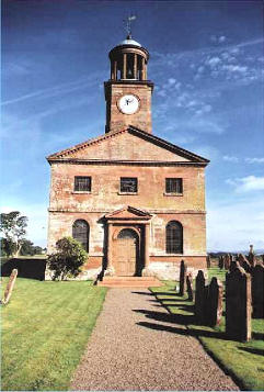
 The Church3 occupies a
picturesque situation in the Middle township, on the west side of the Esk, 2½ miles N. of
Longtown. It was built in 1637 on the site of the old fabric, by Sir Richard Graham,
pursuant to the letters patent of Charles I. The benefice is a rectory, valued in the
king's books at £3 11s. 5d., and certified to the ecclesiastical commissioners as of the
average value of £512 per annum. The right hon. Sir J. R. G. Graham, Bart., the lord of
the manor, is patron, and the Rev. William Graham, M.A., is rector, for whom the Rev.
Henry Hodgson officiates. There are four schools in the parish, which receive amongst them
the sum of £20 from the bequest of Lady Widdrington; here is a small alms house, erected
by Sir James Graham, for the reception of aged families. Near the church is an ancient
border fortress4, consisting of a square tower, "with a
ground floor and two apartments above, one over the other; in the first floor it was usual
to keep the cattle; in the two last was lodged the family." About a mile from the
church is a freestone quarry, and a good bridge near the spot where several of the rebels
lost their lives in 1745. Population in 1841, 458; rateable value, £3756.
The Church3 occupies a
picturesque situation in the Middle township, on the west side of the Esk, 2½ miles N. of
Longtown. It was built in 1637 on the site of the old fabric, by Sir Richard Graham,
pursuant to the letters patent of Charles I. The benefice is a rectory, valued in the
king's books at £3 11s. 5d., and certified to the ecclesiastical commissioners as of the
average value of £512 per annum. The right hon. Sir J. R. G. Graham, Bart., the lord of
the manor, is patron, and the Rev. William Graham, M.A., is rector, for whom the Rev.
Henry Hodgson officiates. There are four schools in the parish, which receive amongst them
the sum of £20 from the bequest of Lady Widdrington; here is a small alms house, erected
by Sir James Graham, for the reception of aged families. Near the church is an ancient
border fortress4, consisting of a square tower, "with a
ground floor and two apartments above, one over the other; in the first floor it was usual
to keep the cattle; in the two last was lodged the family." About a mile from the
church is a freestone quarry, and a good bridge near the spot where several of the rebels
lost their lives in 1745. Population in 1841, 458; rateable value, £3756.
Moat township contains 2600 acres, and extends about 2 miles along the south bank of the Liddel, where are situated the ruins of Liddel strength5. Population in 1841, 205 ; rateable value, £1412.
Nether township lies between the rivers Sark and Esk, extending from one to four miles W., N.N.W., and S.S.W. of Longtown. It comprises Solway Moss6, and part of the once Debateable Lands. On the 16th of Nov. 1771, in a dark tempestuous night, the inhabitants of the plain were alarmed by a sudden and overwhelming irruption of Solway Moss. "Those who lived near where the irruption broke out soon found their dwellings surrounded with a thick black fluid, moving rapidly on, with large solid masses upon it, like floating islands, and deluging the extensive plain as it advanced; so that it was with difficulty and speed that the affrighted inhabitants gained the higher grounds, and escaped the feculent flood. Those who were aroused from their beds were obliged to fly, nearly in a state of nudity, and all left their cattle and furniture a prey to the black nauseous inundation. The dawn of the next morning exhibited to them an awful scene of horror and desolation; their houses and fields were completely buried in a stagnant lake, which continued to increase for several weeks, till it extended over about 500 acres, and was, in some places, 30 feet deep. The twenty-eight families, whose houses and little farms lay ruined in this pitchy pool, vomited from the bowels of the earth, were reduced to the greatest distress, having, as it was said, the world totally to begin again; but their sufferings were greatly alleviated by their generous landlord, who, by the skill of Mr. A. J. Wilson, an illiterate but talented Yorkshireman, soon regained this paradise, at a much less cost than was anticipated. To effect this arduous task, Mr. Wilson cut channels, in various directions, to the Esk, and formed several reservoirs on the higher grounds, where, by means of flood-gates, he collected and let off large bodies of water into the different channels, along the sides of which men were stationed, to roll into the streams large masses of mossy earth, which were hardened by the sun. By this simple but sensible contrivance, which he called hashing7, the immense accumulation of extraneous water was carried away, and the plain restored to its former fertile state, as if no such astonishing event had happened." The work, says Mr. Gilpin, was completed in a few days, and the whole expense did not amount to twenty pounds. Rateable value of Nether township, £3351; pop. 444.
Joseph Faulder, who was born here, and lived in the township for about a century, died at Alstonby, in Kirklinton parish, about four years ago, at the patriarchal age of 104 years.
Nichol Forest chapelry contains 10,360 acres, and extends ten miles along the rivers Liddel and Kershope, which separate it from Scotland. It contains 825 inhabitants, resident in 169 scattered dwellings, distant from six to fourteen miles N.E. of Longtown. The Chapel of Ease, a neat edifice, situated at Kingfield, was rebuilt in 1812, and is about six miles N.E. of the mother church. It is in the patronage of the rector of the parish, and the Rev. John Wannop, M.A , is the perpetual curate - who has a comfortable dwelling, erected, in 1836, by the rector, aided by a grant from queen Anne's bounty. The living was returned by the ecclesiastical commissioners as of the average annual value of £132. Near to the chapel is Kingfield House, the property and occasional residence of James Mounsey, Esq. Penton, about 1½ mile S.W., is the seat of George Tinniswood, Esq.; and here the river Liddel rolls its rapid stream with much grandeur, forming, in some places, fine cascades, which foam over huge rocks and abrupt precipices. Near to the brink of the river is a mineral spring; but it has been partly destroyed by the working of a coal mine. Armstrong, the Poet8, was son to a minister of Canonby, on the Scotch side of the Liddel. The rateable value of Nichol Forest is £3489, and its principal landowners are Sir James Graham, James Mounsey, Esq., and John Charlton, Esq. The School, which receives £5 a year from lady Widdrington's bequest, is situate at Warwick's land.
Mannix & Whellan, History, Gazetteer and Directory of Cumberland, 1847